Dartmoor is no different to anywhere else in the country as far as trig points are concerned – they appear everywhere. But there seems to be a growing hobby of visiting as many of these ‘modern menhirs’ as possible and so this page is for anybody who wanted to call on the Dartmoor ones.
The first trig points began appearing in 1935, their purpose was to enable the accurate re-mapping of Great Britain. This was done by a method known as triangulation which was devised by Martin Hotine, a mathematics expert and cartographer. Once all the trig points were sited it was always possible to see at least two other trig points when stood by one. This mean that it was possible to triangulate the measurements between the lines-of sight of other points thus arriving at a grid of triangles. Once these were measured against a base line it provided, what for the times, was a very accurate measuring system for the whole country.
Trig Points are short, square based pyramids, usually white but that depends on weathering and how many animals have used it as a rubbing post. On the top of the trig is a brass plate with a depression in the middle and three hooped arms. This was used to fix the theodolite when the surveyors were taking their measurements. Another brass plate was fixed to the side on which was marked, O/S/B/M – (Ordnance Survey Bench Mark), and the reference number for the trig point.
In this modern age of GPS, digital mapping, and laser measuring the trig point’s role has become obsolete which means many of them are being taken away. This in many respects is sad because not only are we losing a familiar landscape feature we are losing an excellent navigational aid. Those who letterbox will soon tell you that there are hundreds of letterbox sites that have trig point bearings in their clues.

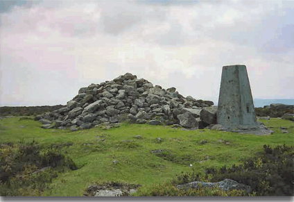
Hambledon Trig Point.
In 1992 a scheme was launched to ‘adopt a trig pillar’ whereby anybody could adopt a trig point as long as they maintained it and had the landowners consent which many walking clubs and individuals did. However this still has not stopped the removal of many of the famous land marks.
Today, on Dartmoor there are around about 32 trig points still stood up on the high tors and moors and are listed along with their height in feet and the OS grid reference below:
| Location | Height | OS Grid Ref. | Location | Height | OS Grid Ref. | |
| Yes tor | 2,019 | 58085 90151 | Butterdon | 1,189 | 65530 58643 | |
| Great Links tor | 1,896 | 55080 86758 | Ringmoor Down | 1,148 | 57527 66745 | |
| Cosdon Hill | 1,804 | 63610 91501 | Bel tor | 1,143 | 69640 72983 | |
| Hameldon tor | 1,727 | 70315 80568 | East Hill | 1,137 | 59577 93893 | |
| Ryder’s Hill | 1,687 | 65975 69058 | Cranbrook Castle | 1,098 | 73863 88913 | |
| North Hessary tor | 1,685 | 57872 74213 | Westcott | 1,092 | 78790 86376 | |
| Lee Moor | 1,611 | 60255 64498 | Brent Hill | 1,022 | 70303 61698 | |
| Rippon tor | 1,537 | 74655 75566 | Shaugh Moor | 988 | 55893 63208 | |
| Three Barrows | 1,508 | 65320 62580 | Wallaford Down | 952 | 70558 65885 | |
| Cramber tor | 1,455 | 59237 71210 | Cranbrook – New Site | 944 | 74200 88801 | |
| Cox tor | 1,438 | 53070 76176 | Tor Down | 889 | 69515 91838 | |
| Sourton tor | 1,431 | 54330 89818 | Chericombe Head | 844 | 82058 80788 | |
| Easdon tor | 1,426 | 72945 82311 | Higher Bowden | 682 | 63020 57233 | |
| Bellever tor | 1,406 | 64463 76436 | Roborough Down | 645 | 50605 64126 | |
| Penn Beacon | 1,395 | 59940 62933 | ||||
| Meldon Hill | 1,274 | 69568 86103 | Unconfirmed | |||
| Gibbet Hill | 1,153 | 50310 81141 | Blackingstone Quarry | 1,044 | 78365 85846 | |
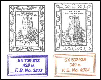
With the exception of Cranbrook Castle all the trig points are still shown on the Ordnance Survey maps. There is currently a series of letterboxes on the moor with a stamp for each trig point which makes for a very interesting collection.

 Legendary Dartmoor The many aspects past and present of Dartmoor

Hi, living just outside of Ashburton, the good lady and myself drove up onto Dartmoor to take out little Jack Russell dog for a walk onto Dartmoor, and as we rambled away, we came across two pillars of stone (approximately three feet high, 1ft x 1ft square) that held the wording (E.P.B. 1837) and i am unable to locate any information as to what they are or were for. They are approximately located, three miles from Kitty Jay’s grave. I do hope you can help me. Regards Peter Lewis
Hi, what you came across are a couple of boundstones which mark the limits of the old manor of Buckland in the Moor. The EPB represents the name of a once-time Lord of the Manor Edmund Pollexfen Bastard and the date the stone was erected – 1837. See also my Legendary Dartmoor webpage on the stones – https://www.legendarydartmoor.co.uk/top-tor-to-buckland-beacon.htm
Is the `number of trig points on Dartmoor still the same? Is there any ‘officially’ produced booklet / passport for collecting all the trigs 🙂
As far as I know they are still there, although no booklet exists there is a group where you can record all the trigs that you find – http://trigpointing.uk/