 Legendary Dartmoor The many aspects past and present of Dartmoor

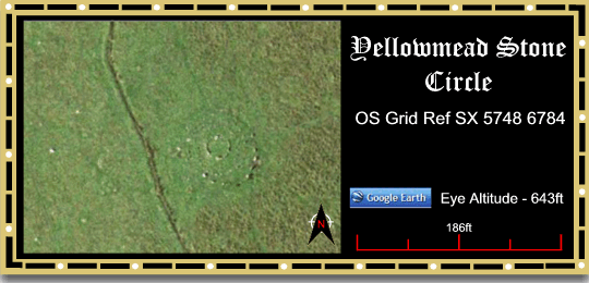
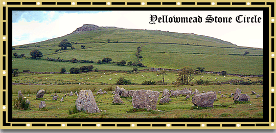
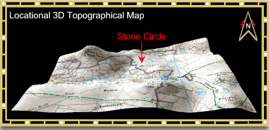
About half a mile to the south east of Sheepstor lies the Yellowmead Stone Circle or to be precise ‘Circles’ because there are in fact four of them. Butler (1994, p.74) describes the rings as ‘fourfold circles‘ although other authors have referred to them as ‘concentric circles’, English Heritage being one of them: ‘Concentric circles usually comprise a double ring of stones, although the Shapbeck stone circle, Cumbria has three rings and Yellowmead in Devon has four rings. The rings are either all regular or irregular, though in ruined examples it is difficult to tell.’, (English Heritage 2009, online source – HERE).
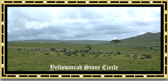
In terms of the Dartmoor stone circles Yellowmead could be considered as a fairly recent discovery as it was only brought to people’s attention by Richard Hanson Worth in 1921. The very reason that the circles had not been previously noted was that they were buried under a thick covering of heather. A couple of years previous to Worth’s discovery the vegetation had been burned off leaving just the scorched earth so that it was possible for him to discern some tell-tale lumps and bumps. At the time there were but three stones standing but after investigation Worth decided that buried under the turf were other fallen stones that made up a double circle. In the same year, the Reverend Hugh Breton along with William Manning of nearby Yellowmead Farm and some other helpers began the work of unearthing the fallen stones, this work was carried out on behalf of the Dartmoor Preservation Society. Once unearthed Breton and his crew re-erected each stone into what they considered to be its original socket hole. It did not take the team long to realise that they were excavating not a double stone circle but in fact a fourfold stone circle. It was discovered that the outer ring was composed of slabs ranging from 4 – 6ft (1.21 – 1.82m) long and sadly many of them had been re-cycled for use in the nearby newtake wall which lay 100 yards (91.44m) to the west of the circle. It was also supposed that a further three stones had been taken and converted into a small clapper bridge which spanned a stream 200 yards (182m) to the north-west of the circle. For some reason it was the north eastern sector of the circle’s arc that had the majority of the stones plundered. This outer circle measured 66ft (20.11m) in diameter and was made up of 24 stones, the largest of which was 4ft 3in (1.29m) high when re-erected. At the top of this stone were two or three depressions which Breton considered to be cup marks.
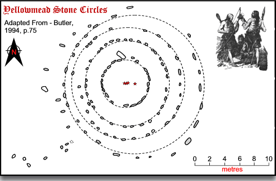
The second circle was made up of 28 stones and had a diameter of 50ft (15.24m) whilst the third circle consisted of 31 even smaller stones that described a diameter of 37ft (11.27m). The inner circle was made of, ‘thick ponderous stones’ which numbered 21 and had a diameter of 22ft (6.70m). At the time Breton suggested that this inner circle enclosed either a kistvaen of which no traces remained or a large cairn. In order to establish what exactly the circles enclosed it was proposed that at a later date the Dartmoor Preservation Society would excavate the inner platform in the hope of finding a burial urn, (Breton, 1990, pp. 58 – 59). Since Breton’s work it has now been considered that the inner circled formed a kerb which enclosed a cairn, the foundations of which can be seen today, it is also thought that the cairn did not cover the outer three rings. It may also be that associated with the circles was a stone row which ran at right angles to the outer ring and ran down the hillside, (Butler, 1994, p.74).
This is an observation not missed by Hemery who proffers the theory that there is evidence that at one time there was a double stone row that ran for 36 yards (32.91m) in the direction of the newtake wall, (Hemery, 1983, p.162). Darvill, (1996, p.200) considers that there is evidence to suggest at least 8 parallel stone rows once approached the circles from the west and again noting how many of these stones had been removed for use in the post medieval leat that runs nearby.
It has already been noted above that the Yellowmead Stone Circles were restored in 1921 but how faithful was the restoration? At the time Worth commented that the work had been, ‘very faithfully done‘ in a, ‘perfect system of restoration‘, (Butler, 1994, p.74). During the whole process only one stone was brought in from elsewhere and erected in the outer circle, (Petit, 1974, p.102).
The Yellowmead circles are by no means the only example of concentric circles on Dartmoor, other being the Shovel Down four ring circles and possible the one-time double ring circles at Merrivale and Langstone Moor, (Gerrard, 1997, p.61). Looking at a nationwide perspective these concentric circles have no obvious biases in their distribution with examples occurring in the South West, Cumbria and Scotland. There is no clear preference for location as some are sited on low ground (70m OD) whilst others can be found on higher ground (200m OD), in the case of Yellowmead the circles are at 283m OD. There appears to be some continuity with regards to nearby features as many can be found near streams and/or other Early Bronze Age features. Again, Yellowmead complies with this idea as the Sheepstor Brook runs nearby and there is a whole host of EBA Features on nearby Ringmoor Down.
Under the Dartmoor National Park Authority’s Monument Management Scheme the Yellowmead Circles underwent a geophysical survey in the early part of 2008 this was followed up in the autumn with a ground truthing excavation. The work was carried out by Bournemouth University and the aim of the initial geophysical survey was to answer four key questions. Firstly, how accurate was the restoration work carried out in 1921? Secondly, was the monument a multiple stone circle with a possible ditch or was it a ring cairn with associated stone circles? Thirdly, was there any evidence of features which linked the stone circles with the small cairn situated near to the main circle? And finally, was there any evidence of the supposed four stone rows which led downslope from the main circles and were they still buried beneath the peat? The results from the survey indicated that indeed the reconstruction of 1821 was accurate and no additional rings were found. There were although there was evidence of a possible anomaly close to the cairn on the upslope also no buried features lying between the stone circles and the cairn. The results also led to the conclusion that the site could well be interpreted as a ring cairn.
Following the geophysical survey three trenches were excavated with regards to the stone circles, the first was cut over the anomaly which lay near the outlying cairn. This revealed a number of fallen stone that appeared to have come from adjacent settings although there was no signs of their socket holes. Despite this it was felt that they were to be archaeological features as opposed to geological features. The second trench was slotted in a gap through the outer stones of the circles, its purpose was to see if there were traces of a ditch and to evaluate the accuracy of the 1921 restoration. This trench revealed a fallen stone from the outer circle which Hugh Breton and his team had missed when they carried out their work, there were also no signs of any ditch. The third trench was put over an area where there was a strong possibility of finding the suggested stone rows that previous writers had intimated at. The team found stones set into the peat which formed a small arc and some fallen stones that aligned to those already visible which appear to confirm the existence and location of the stone rows. Out of all the trenches it was the third one that was to produce the one single find in the form of a flint scraper with a suggested dated to the Neolithic/Early Bronze Age periods. The find was of good quality and is said to have been fashioned by a skilled and experienced flint knapper. Further work is now being done on the findings which hopefully will answer some questions that have arisen regarding the stone locations and depths. (Armstrong, 2009, pp. 35 -36).
The MMS also funded some restoration work on the circle which entailed the re-erection of a fallen stone that stood within one of the circles.
Incidentally, if anyone was wondering where the name of the circles came from it was first recorded in 1256 in the assize rolls as la Hollemede and it has been suggested that the ‘h’ is inorganic and would have been pronounced with it ergo – Ollemede which means ‘old meadowland’, Glover et al. 1992, p.246).
References.
Armstrong, K. 2009. Yellowmead Stone Circles, Sheepstor, Dartmoor Magazine No.94, Spring Issue.
Breton, H. 1990. The Forest of Dartmoor, Liverton: Forest Publishing.
Butler, J. 1994. Dartmoor Atlas of Antiquities – Vol. IV, Tiverton: Devon Books.
Darvill, T. 1996. Prehistoric Britain from the Air, Cambridge: Cambridge University Press.
Gerrard, S. 1997. Dartmoor – Landscapes Through Time, London: Batsford.
Gover, J.E.B., Mawer, A. & Stenton, 1992. The Place-Names of Devon, Nottingham: The English Place Name Society
Hemery, E. 1983. High Dartmoor, London: Hale Publishing.
Pettit, P. 1974. Prehistoric Dartmoor, Newton Abbot: David & Charles.
Another highly informative and interesting article.
I shall have to revisit , if only to check out where the stone row might have been!