 Legendary Dartmoor The many aspects past and present of Dartmoor

On Dartmoor there are numerous enigmatic prehistoric standing stones, there are hundreds of boundstones, there are many ancient crosses, and there are a few stones which are a combination of them all. It could be said that the latter category of stones have over time been re-cycled to represent different beliefs and ideologies of their times. Oddly enough most of them are clustered around the Sticklepath/Okehampton area and are loosely described as pre-Christian stones. All of them have mysterious inscriptions on them whose meanings have been lost in the pagan mists of time. In later times the stones bear witness to Christian beliefs in the forms of sacred crosses carved on them. It almost seems that there was a determined effort to sanitise any early significance of their intent by the addition of those Christian symbols. Just outside Okehampton can be found the “Sourton Down Cross,” further down the road at Sourton is the “Oxo Stone” which now stands on the small green beside the main road. Just to the north-west of Sticklepath sits “The Honest Man” at the junction of Bude Lane, and below this just above the ‘Lady Well’ is what I refer to as the “Sticklepath Stone” for want of a name. Today the stone, depending on the season and the vegetation growth, is virtually invisible and all the various inscriptions have worn away. The heritage Gateway classifies it as being a “scheduled monument 1019216: Boundary stone 110m north west of St. Mary’s Church.” According to them the monument type an date is “Boundary Marker ( constructed, Post Roman to XI -410 AD (between) to 1066 AD (between)” – make of those dates what you will.
So, let’s start with the latest classification of a “Boundary Marker,” and hand over to Dave Brewer’s thoughts. “now used as a boundary marker. formerly by the parishes of Belstone and Sampford Courtenay but since 1987 by the newly formed parish of Sticklepath… It was first placed there in 1829 when the Okehampton – Exeter road was improved, presumably having previously been in the path of the road at the time.” – p.185. The nearby “Honest Man” stone also served the same purpose as a boundary marker for both the old and new parishes. This in itself begs a question, were the stones used as a matter of convenience by simply re-cycling them or was there some belief and respect as to their origins?
In 1870 Charles Spence Bate published his two-part works called “The Inscribed Stones and Ancient Crosses of Devon” in which he describes the various inscriptions on the Sticklepath Stone. He notes how “On the north face a cross stands in relief, the top of which is surmounted by a round knob, from which, to the arms of the cross, the distance is one foot six inches, while from the lower part of the arms, which are nine inches broad, to the lower extremity of the shaft of the sculptured cross is one foot. The eastern face is sculptured from the summit to the base of the stone. The uppermost engraving is about half a circle, the upper half being wanting. Below this semicircle is a small St. Andrew’s cross, beneath which is a cartouche-like ornament. It is of a long, oval shape, with a contraction of the sides near the middle. Beneath this again is a second St. Andrew’s cross, below which are two conformable waved lines like the letter S.” – p.23. As noted above the Dartmoor weather has done a good job in eroding these incisions but the hole in which the “round knob” is still visible but as to its purpose nobody seems to know.
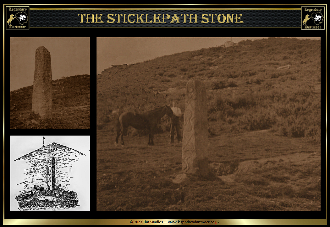
A few years later John Chudleigh’s book of 1892 relates how “There is always a faint suspicion how far these inscriptions may be of the Pickwickian Bill Stumps order, (referring to when Pickwick discovered an old inscription on a stone in the Pickwick Papers), but I do not think the ones in question are to be read in quite the same manner: moreover it is extremely difficult to make out what form the inscriptions really take, so worn are they from long exposure. The inscribed side was too was in shadow at the time of my visit. As far as I could make out there is a Saint Andrew’s cross at the top, then a sort of hour glass figure or figure 8; below these are two more crosses, the lower going off into another curve. I daresay however, another observer with a different light on the stone might slightly vary this description. I could not trace any markings, except natural ones on the other faces.” – p.111.
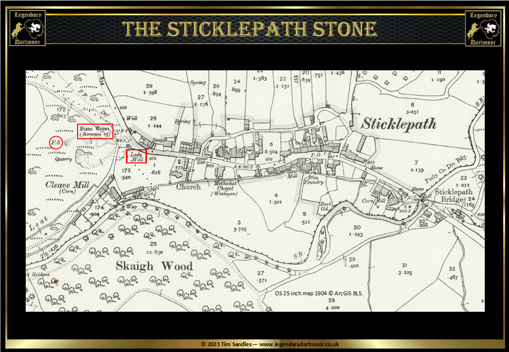
Moving slightly on in time there is an account which not only reiterates the boundary marker idea but also mentions the incised crosses. In his book of 1895 Pages described the stone as having “a height of about five and a half feet with a thickness of eleven inches, consists of a very substantial shaft… On the side facing the well, the shaft is graven with St. Andrew’s crosses and strange devices, which appear to bear no particular meaning, all of which are incised, while on the right face is a raised Latin cross, surmounted by a boss. The other sides are smooth. This interesting relic has no history; but I am told that it marks the venville bounds of Belstone and Samford Courtenay, and that when these bounds are ‘beaten’ once in every seven years, a flag is hoisted on the post immediately behind the so-called cross to celebrate the event.” – pp.83 -84. As can be seen from the ordnance Survey map below that a few years later the stone is delineated as being a “Stone Cross (Remains of).” You can also see the flag staff, marked “FS” and the well, as mentioned by Page.
Obviously it is impossible to know the exact original location of the stone as well as the meanings of the early symbols. However, is it just a coincidence that a pagan stone had been ‘Christianised’ and that just below is the ‘holy’ ‘Lady Well‘? In a similar light, above the stone and well is the White Rock where Charles Wesley used to preach his outdoor sermons. Crosses, a well and a preaching place along with the nearby church – seems like a determined effort to reiterate the Christian connection. The other intriguing question is how come when there are so few remaining examples of such inscribed stones in Devon and why is there such a concentrated number in the Okehampton/Sourton area? There is also another cluster to be found at nearby Tavistock but in all likelihood these are not in their original locations. There is definitely a connection with the St. Andrew’s Crosses and the mysterious circles and half circles which appear on the various stones. The crosses are easily explained but what significance were the other symbols and to who and why?

Brewer, D. 2002, Dartmoor Boundary Markers, Tiverton: Halsgrove.
Bate, C. S. 1881 – 4, The Inscribed Stones and Ancient Crosses of Devon, Plymouth: Transactions of the Plymouth Institute.
Chudleigh, J. 1892, An Exploration of Dartmoor’s Antiquities. Pembury: John PegG Publishing.
Page, J. Ll. W. 1895, An Exploration of Dartmoor, London: Seeley & Co. Ltd.