 Legendary Dartmoor The many aspects past and present of Dartmoor

Whilst thumbing through Burnard’s book – Dartmoor Pictorial Records I came across a chapter that I had never really took much notice of before. It is entitled, ‘The Great Triangle’ and opens like this:
‘Draw a straight line on the six-inch Ordnance map sheet CXII. N.E. from Sheeps Tor to Leather Tor, another from Lether Tor to Down Tor: and from Down Tor to Sheeps Tor, and it will be found that an equilateral triangle is formed whose sides are exactly one mile and one-sixth long‘, (1986, Vol. IV, P.1).
Always up for a spot of geographical geometry I tried the same experiment with the Memory Map computer system and as you can see the results below are pretty conclusive.
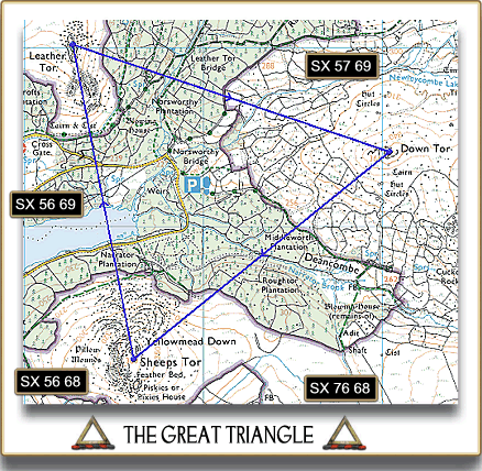
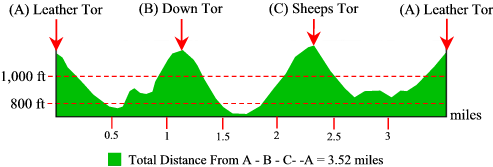
If the spot heights on Sheepstor and Down Tor along with the highest point on Leather Tor are used as the nodes then according to Memory Map each side of the triangle measures 1.17m. The total circumference of ‘The Great Triangle’ is 3.52 miles (5.66 km) and a profile of its length can be seen below:
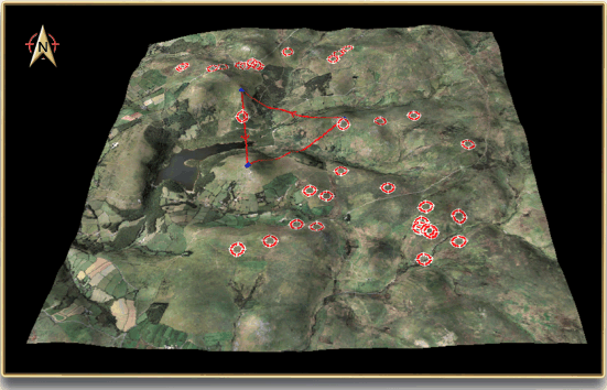
Having plotted the ‘Triangle’ it was then interesting to play around with the various man-made landscape features to see if anything else became evident. I know this is very tongue in cheek and totally unsubstantiated but there was one aspect that leapt out of the page. Before explaining what, there are numerous ifs, buts and maybes to consider. Firstly, one look at the above map extract will tell you that the whole area has been heavily influenced by man. There are numerous agricultural enclosures, industrial tin extraction activities and then the modern intrusion of a reservoir and a huge plantation. You will also see from the map that there are a number of prehistoric features such as settlements, hut circles, cairns, cists and stone rows. These are what we know exist today, heaven knows how many other such features have been lost or destroyed by later human activities? Secondly, much of the area inside ‘The Great Triangle’ is either covered by forestation or submerged under the waters of Burrator Reservoir, again it is impossible to know what existing features they hide. Having said that and making allowances for any lost prehistoric relics it is interesting to see the results when the surviving Bronze Age ritual features are plotted in correlation to the ‘Triangle’. The map below shows most of the known kists, cairns and stone rows in the area, all of which are assumed to be connected with ritual and burial.
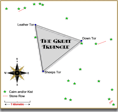
As can be seen, the area inside ‘The Great Triangle’ is today devoid of anything that resembles a Bronze Age ritual monument. Was this because for some unexplained reason they considered that there was something ‘special’ about the area?
Now, in general archaeological terms this observation can be argued that most of the area encompassed by the so-called ‘Great Triangle’ comprises of mostly valley sides and bottoms which is not the type of landscape where you would expect to see concentrations of prehistoric ritual monuments. The 3D aerial map below shows ‘The Great Triangle’ with all the known cairns and kists in the surrounding area and as can be seen the majority are situated on the higher ground and slopes.
However, when the cairns are taken out of the picture it is obvious that many of the kists marked on the OS map are located on the valley slopes apart from inside ‘The Giant Triangle’ as can be seen below:
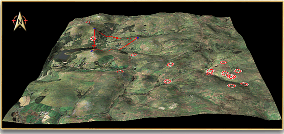
It can also be argued that there are no examples of kists or cairns to the west and east of ‘The Great Triangle’ but equally it can be stated that these are the areas that have been subjected to man’s agricultural and industrial activities and any such features have probably been destroyed, submerged or lost due to a result of forestation.
Either way, this exercise is intended to be a light-hearted and tongue-in-cheek expanded theory on an observation of a geographical and geometrical observation made some 100 years ago. As far as I know there have been no reports of anybody going missing whilst venturing inside ‘The Great Triangle’ so I don’t think we have a Dartmoor version of The Bermuda Triangle? Mind you, Crazywell Pool is only half a mile outside the Triangle’s limits and there have been some weird goings on there over the centuries?
Reference.
Burnard, R. 1986. Dartmoor Pictorial Records. Exeter: Devon Books.