 Legendary Dartmoor The many aspects past and present of Dartmoor

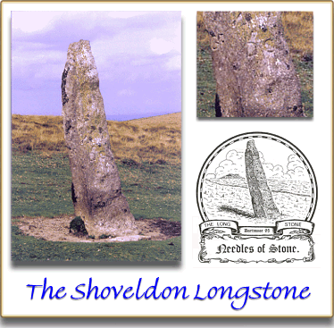
Shoveldon, Shuggledown, Shuffledown or Shovel Down as the Ordnance Survey insist on recording it is another of Dartmoor’s finest prehistoric landscapes consisting of settlements, field systems, cairns, stone rows, and slap, bang in the centre ‘The Longstone’. When viewed from the south west it is evident by its weary lean that the menhir has stood on its spot for many, many, many years.
The Longstone is associated with a double stone row which along with two other double rows and two single rows make up the Shoveldon complex. The menhir stands at the northern end of its 148m stone row and is positioned across the linear alignment so as to act as a blocking stone. The height above ground of the granite pillar is 3.1m which makes it the fourth tallest menhir still standing on Dartmoor. It can be estimated that such a granite pillar would weigh in the region of 4 tons which by no stretch of the imagination would have been an easy task to erect. As far as dating goes, the consensus of informed opinion is that the menhir was contemporary with the surrounding Bronze Age features which would place it at around 3,500 years old. However, the English Heritage Pastscape Record is rather non-committal and suggests that it: ‘may be of a contemporary date‘, to the Bronze Age stone row, see full record at the link opposite.
One thing that is fairly certain is that The Longstone was in-situ in 1240 because it was recorded as a boundary stone mentioned in the Perambulation of the Forest bounds. The actual wording that mentions a longstone was: ‘et inde linealiter usque ad Heigheston‘. In the 1609 Perambulation the wording read: ‘and from thence nere one myle to Hingeston, al’s Highstone, in the east quarter lyinge near Fernworthie hedges‘, (Brewer, 2002, p.24). As always there are differing opinions and Butler, (1991, p.1820 argues the following:
‘It has been supposed that the Longstone is identical with the boundary mark on the border of the Forest called Heighstone in 1240… The neighbouring boundary points are very uncertain and this doubtful attribution causes the Forest border to make an awkward detour eastwards. In 1609 the Highstone was described as lying near Fernworthy Hedges a good distance to the south-west, having apparently fallen at some time after 1240‘.
There are two points here; firstly, whether or not the menhir had fallen over depends on ones interpretation of the word lyinge, it could mean, as suggested by Butler, that it was laid on the ground. Alternatively it could just simply mean lying as in a locational sense. The fact that Fernworthy Hedges is a fair distance away then enters into the argument as to whether the actual intended boundary point was The Longstone or the Heathstone which lies to the west of Fernworthy Hedges. Either way this page is concerned with The Longstone and not the arguments over the Forest boundary.
In later years The Longstone was used once again as a boundary marker, this time denoting a meeting place of the boundaries of Gidleigh parish, Chagford Parish and the Duchy of Cornwall lands. To this end the initials; ‘DC’ (Duchy of Cornwall), ‘C’ (Chagford Parish) and ‘G’ (Gidleigh Parish) were incised on three of the pillar’s sides. In the enlarged photo below you can see the respective ‘GP’ and ‘DC’ carvings:
References.
Brewer, D. 2002. Dartmoor Boundary Markers. Tiverton: Halsgrove Publishing.
Butler, J. 1991. Dartmoor Atlas of Antiquities – Vol. II. Exeter: Devon Books