 Legendary Dartmoor The many aspects past and present of Dartmoor

Dartmoor is known for many things and people see it in various ways but for whatever combination you use the situation arises where you have a vast tract of land and people wishing to see it. This produces a need for those visitors to be able to navigate themselves either along its roads or over the vast expanses of moorland. It is interesting to see how over a period of about 150 years the logistics of navigation have dramatically changed.
During the mid eighteen hundreds there was a great upsurge in wealthy people wanting to visit the so-called ‘picturesque’ scenery of Britain. This desire was fed by the numerous artists, poets, and writers of the time producing works that portrayed wild rugged scenery in a romantic and somewhat nostalgic manner. Nationally there were artists such as Constable, Turner, Gilpin, Bewick, and a host of others painting rugged and idyllic pictures of the British Landscape. There were writers such as Austen, Wordsworth, Bynge, Price etc producing poetry and fiction set in remote, wild locations. All this fuelled the ‘need’ for the wealthy to visit such places and see for themselves the romantic landscapes. Suddenly, a farm workers hovel became a rustic feature in the landscape and added to the surreal ideal of a typical rural idyll. What would have been described as a scene of squalor fifty years previous was now ‘quaint’.
On a local Dartmoor level you had artists like the Widgery’s, Rev. John Swete, Benjamin Leader, William Morrish, and a multitude of others producing paintings and sketches of the wild scenery of the moor. There were then writers such as Swete, Page, Crossing, Rowe, Worth, and Bray all describing their travels throughout Dartmoor and the plethora of features they saw. Again, many of these people were portraying a romantic and idyllic insight into ‘picturesque’ Dartmoor. So, those rich enough to afford it came in search of those places which have become the ‘Mecca’s’ we know today. This created a problem, and I will use Cranmere Pool to demonstrate the dilemma. Cartography of this period was not very conducive to navigation as the maps were very basic and recorded very few features. Imagine then arriving on Dartmoor for the first time and wanting to get to Cranmere Pool. You can see from Benjamin Donn’s 1765 map of Devon it does in fact show the pool – see ill. 1 here. I think it fair to say that it would be a difficult and daunting task to step out on the moor and get to Cranmere with this map. Between 1795 and 1796 Captain William Mudge and Isaac Dalby began triangulating South Devon, fixing trig stations on the heights of Dartmoor. However, at this time the task of triangulating South Devon was made virtually impossible by dint of the fact that trig stations on the north moor were not intervisible from the south. But in the early 1800’s the now Lieutenant-Colonel Mudge and Captain Colby triangulated much of Dartmoor’s interior thus allowing the production of sheet 25 which was the first Ordnance Survey map showing Dartmoor and published on the 11th of October 1809. Even so, it would still be difficult to navigate to Cranmere Pool using this map – see ill. 2 here, I have highlighted the pool in green. This then opened up the opportunity for what I would argue was the first practical method of safe navigation for the visitor, namely, the local guide. Probably the most famous of which was James Perrott of Chagford who it could be argued was the instigator of Cranmere Pool’s fame. He and others like him soon provided the wealthy with a means of seeing the ‘picturesque’ at first hand that did not involve any danger. To this very day guides, be they D.N.P.A officials or private, still offer the self same service as Perrott did in the 1850’s.
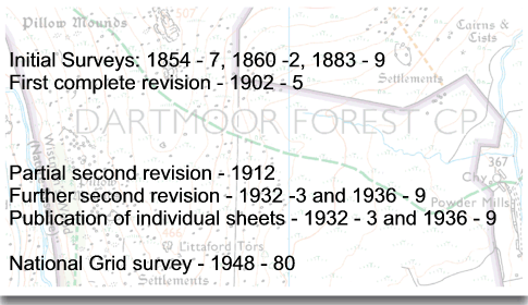
Slowly the numbers of visitors increased and by a combination of improved road and rail networks, better provisions for the growing tourist trade, ie hotels and cafes, and increasing popularity of the area. Before long it was not just the wealthy that could afford to visit Dartmoor, people from all classes were visiting and exploring the area. Throughout the same period cartography was striding forward in leaps and bounds and through the work of the Ordnance Survey detailed maps were being produced in various scales. If you look at the chronology of the OS maps it reads thus:
During the first half of the twentieth century social improvements meant more visitors, and once bicycles and motor vehicles became affordable influx turned into a flood. By now the maps were accurate, readable and affordable. This in turn led to ‘ramblers’ taking themselves out into the wilds of dartmoor, accompanied by maps and compass. By the 1960’s Dartmoor was covered by a series of some 17 separate maps which were printed in three basic colours, black, blue and orange and cost the princely sum of 5s 6d – see ill. 3 here. This particular map is not only an example of map history but also early letterboxing days. At this period there were probably about 15 letterboxes on the whole of Dartmoor and as there were so few it was general practice to put copies of the stamps on the maps. On this particular map cover are copies of the original Crow tor, Cranmere Pool, and Livingstone Falls stamps. Another event which points to the increasing numbers of ramblers on Dartmoor was the founding of the Dartmoor rescue Group in 1968. Over the next thirty years the OS maps improved further in detail and colour with the addition of double sided maps which nearly covered the whole of the national park – see ill. 4 here. In the late 1990’s waterproof maps were produced which meant the actual maps lasted a lot longer. I can remember before this innovation a map would probably last me for a month or two which was an expensive exercise. In the early 1980’s Harvey Maps appeared on the scene which from my personal point of view are easier for quick navigation as they are less cluttered – see ill. 5 here.
Then we come to a plethora of gadgetry (of which I am a sucker), some useful and others quirky. The most useful advance in mapping was the introduction of the CD Maps, the first of which was the Memory Map programme in 2000, closely followed by Anquet. Six years later the advances in the software has made these programmes invaluable. There are various maps scales, the ability to print maps, plot routes, see aerial – see ill. 6 here, and 3D maps – see ill. 7 here, interact with handheld PDA’S, and use in conjunction with GPS systems. Personally speaking, although I have both programmes I find the Memory Map the best system.
Then we come on to probably the biggest revolution in navigation – the GPS, on the 26th June 1993 the US aiforce launched the 24th of a series of satellites which completed the GPS network. After a few early teething problems the system now enabled people to locate, navigate, and pin point anything on the globe. I remember the first Garmin system I purchased in 1998, it took ages to lock on to the system, was the size of a house brick and I never used it. Today I have a modern version that engages quickly, is pretty accurate, highly visible and I don’t use that much either. In fact come to think of it on the odd occasions I have wanted to use it the batteries have been flat.
From about the late 1890’s the other form of navigation was for the visitor who didn’t necessary want to tramp the moorland expanses but just see what the towns and villages had to offer. In response to them detailed guide books were produced such as ‘Crossing’s Guide to Dartmoor’ which virtually took the visitor step by step through the moor. Along with the topographical books came the introduction of the visitor guide books. Around about 1891 the first Ward-Lock guide was printed, this series of guide books took the visitor to many of the ‘honey spots’ and in addition provided a map and various historical facts – see ill. 8 here. Today they still make interesting reading and give an insight into Dartmoor of the 20th century. The earliest copy I have is from 1924 and in it is a list of hotel tariffs where, for example, it states that a double room at the one-time Duchy Hotel in Princetown would set the visitor back 10/- a night. Inside the cover is a brilliant quotation which I supposed today would be regarded as the company’s ‘mission statement’:
“He that would bring home the wealth of the Indies must carry the wealth of the Indies with him; so it is in travelling – a man must carry knowledge with him if he would bring home knowledge”.
It appears that this national series opened the floodgates for a number of similar publications, like the Homeland Handbook series. Once again these provided everything the visitor should need to know see ill 9. here. The earliest copy I own is from 1905 when the guide would have cost one whole shilling. The book is full of history, photographs, information for train and coach travellers along with details of hotels etc. There is a section especially for cyclists which is another indication of the varied type of visitors that were coming to the moor. In this section the author informs the reader that:
“… cycling in the moor may be rough, not of the quality which recommends itself either to the butterfly rider or to the “scorcher,” but the saving of time and fatigue is immense in getting from place to place where there is no local means of communication”.
One can only imagine what a, “scorcher” did on his bicycle? The most accurate and detailed guide produced was the ‘Western Morning News Guide to Dartmoor’ written by William Crossing. I have a copy dating from 1914 – see ill. 10 here. This was published in five parts all of which cost 6d each and concentrate entirely on the many aspects of Dartmoor. The following years saw other guides published, some locally like the ‘Come to Dartmoor’ official guide – see ill. 11 here, and others published out of the county – see ill. 12 here. With the founding of the National Park in 1951 the business of compiling ‘official guides’ fell into their laps and ever since they have produced what is supposed to be the definitive visitors guide to Dartmoor – see ill 13 here. Over the years there have been numerous guide books – see ill. 14 here, which would fill a bookshelf, some excellent and some make you wonder if the author has ever been to Dartmoor, it’s also interesting to compare the authors with the publishers because it soon becomes obvious that the later changes but the former doesn’t. How can the same author write an ‘official’ guide and then at least two ‘unofficial’ guides, what does he say different to make the one official?
I did mention above about some of the modern gadgets that should be rated as quirky. Over the years I have been suckered into route cards, 360º panoramic view CD’s, a battery powered compass, and a cupboard full of such crap. But what must take the biscuit is a full set of Dartmoor OS maps split into small cards which then fit into a portable magnifier – see ill. 15 here. This little gizmo has now been well and truely recycled as failing eyesight makes it hard enough to read a full size map never mind peering through a magnifying aperture the size of a twenty pence piece.