 Legendary Dartmoor The many aspects past and present of Dartmoor

Landscape is fairly easy to understand until the influence of man becomes involved, we have the natural ability to change and confuse our natural environment by physical, spiritual and historical intervention. At times these can become confusing to say the least, what have the two photographs shown below have in common?
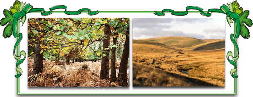
Today there is nothing apparently in common, physically they are different but it could be argued that at one time both landscapes were covered with trees. Spiritually they could represent solitude, natural beauty or a host of other aspects. But at one time they were historically similar as they were both regarded as ‘forests’ this was even after any early disafforestation that may have occurred on Dartmoor. The picture on the left is the New Forest in Hampshire and the one on the right is the Forest of Dartmoor.
This is probably one of the most confusing aspects of Dartmoor as with ‘The Forest’ it is not a case of “can’t see the wood for the trees,” it is more like “can’t see the trees for the forest.” The word ‘forest’ naturally conjures up images of dense woodland covering huge tracts of land, but in the case of the Forest of Dartmoor it refers to a one time ancient royal hunting ground. Hinde, 1985, pp 7-8, explains how:
“By a forest most people mean a large area of growing trees. Some, on the other hand, mean an area of land, not necessarily tree-growing where special laws once applied and which was reserved by the king for hunting. Forests of this kind were widely established in England by William I, and extended and maintained by his Norman and Plantagenet successors. As well as woodland, they included cultivated land, commons, farms, villages and even towns. No forest in the legal sense survives today, but some one-time royal forests are still forests in the tree-growing sense, some retain unenclosed land but are treeless, and some survive as the names of pieces of countryside… Dartmoor for example.”
In Saxon times Dartmoor was more or less an ‘unclaimed’ area, there were possibly some large estates that claimed land on the moorland edges but generally the land was regarded by the nobles as ‘waste’. However, to the ordinary folk the moor provided a valuable and rich summer pasture for grazing their animals. The sheer size of the land meant not only did the moor dwellers utilise the land but so did most of the Devonshire population and in some cases the Cornish folk living on the borders.
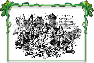
At some time in the 9th century the area became the hunting-ground of the kings of Wessex and it is possibly at this time that the first common rights were introduced. The whole forest system became more structured in Norman times when Dartmoor was deemed as a royal forest. This meant that now the harsh forest laws came into operation, all deer, hares, boars and wolves were considered as property of the king and were strictly preserved. Foresters were appointed to oversee the forest and it is thought that a landowner called Aderet or Adret was one of the first to be appointed sometime between 1066 and 1086. The penalties for contravening these laws could be dire, a Court of Attachment was held every 40 days to deal with such transgressions. This court then made presentments to the Court of Swainmote which was made up of forest freeholders and sat 3 times a year. If the jurors of the Swainmote upheld the indictment the case would then be sent to the Court of Justice for sentencing, this court sat every 3 years. So depending on when the transgression was committed it could take at least 3 years to pass sentence which would mean keeping the transgressor in custody for that period. Therefore the temptation must have been strong to administer justice in anticipation of what the Court of Justice would have handed out rather than incur the costs of three years custody – a similar situation often arose at the Stannary Courts which gave rise to the notorious ‘Lydford Law‘.
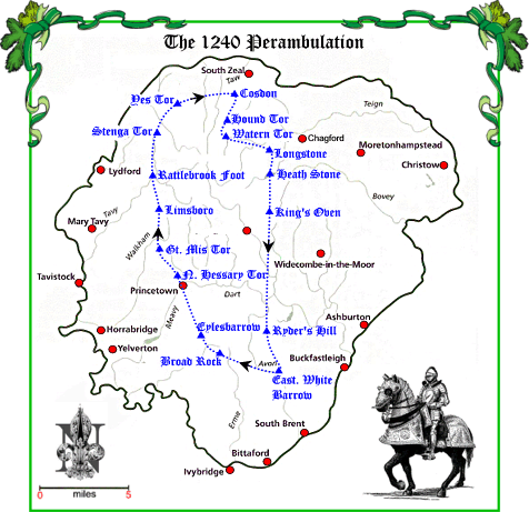
In the 12th century King John afforested the whole of the county of Devon and such was the population’s resentment that after a petition of 1204 it was agreed, in return for a huge sum of money, to disafforest the county “up to the metes of the ancient regards of Dartmoor and Exmoor.” In 1239 the king, Henry III, granted Richard, the Earl of Cornwall, the Forest of Dartmoor and the Manor of Lydford which meant Dartmoor was no longer a ‘forest’ and it became a ‘chase’, but for some reason the term ‘forest’ was always retained. The moor then became under the jurisdiction Common Law and the Manor Court of which originally 3 and later 4 session were held every 3 weeks. These were one for each of what became the 4 quarters of Dartmoor. In 1240 the Sherriff of Devon and 12 “lawful knights of the county” perambulated the Forest in order to record the bounds between the commons of neighbouring landowners and the Forest. This was the result of many disputes between the two landowning sectors and has been known ever since as the ‘1240 Perambulation’, below is a map showing the 42.3 miles of the Forest bounds and the points of reference mentioned in the original document.
On Richard’s death, his son Edmund succeeded to the title of Earl of Cornwall and upon his death in 1300 the Forest and the Manor of Lydford reverted back to the crown. In 1337 King Edward III granted both these lands to his son, Edward, Prince of Wales and Duke of Cornwall. To this day the Forest still belongs to the Duchy of Cornwall and today the 24th Duke of Cornwall is – Prince Charles.
In 1640 a further perambulation was held and its findings presented to a Survey Court in August of the following year. The new survey modified several points of the boundary and clarified others which were in dispute. With this new survey some additional reference points were added between the original 1240 ones thus making it easier to clarify the bounds. It can be seen from the above map that between some of the points there is quite a distance, ie King’s Oven to Ryder’s Hill.

Bound, T. 1992 The Great Walks of Dartmoor, Obelisk Pub., Exeter.
Gill, C. (Ed) 1977 Dartmoor – A New Study, David & Charles, Newton Abbot.
Hayman, R. 2003 Trees, Woodlands & Western Civilisation, Hambledon & London, London.
Hedges, M. 2004 Walking the Forest Bounds of Dartmoor, Peninsula Press, Newton Abbot.
Hinde, T. 1985 Forests of Britain, Victor Gollancz, London.
Rackham, O. 2001, Trees & Woodland in the British Landscape, Phoenix Press, London.
Hi Tim,
Great article. Could you confirm, was the forest outside the blue perambulation line shown above or inside?
Thanks
Mike
Hi Mike,
In 1240 it was inside the blue line.
Regards,
Tim Sandles
Hi Tim,
I am the current parish clerk for Dartmoor Forest Parish Council. Would it be possible to add a link to your excellent article from our council website http://www.dartmoorforestpc.net
Many thanks, Steve
Hi Steve, No problem please feel free 🙂
A rather belated thank you. I have added a reference and link to this article from our website http://www.dartmoorforestpc.net
There’s often talk of replanting native trees on Dartmoor ( I think this would be wrong, but that’s just my opinion). When were the trees themselves removed? Or was it over a period of time that it happened?