 Legendary Dartmoor The many aspects past and present of Dartmoor

Somebody recently asked why there are so many corners marked on the Ordnance Survey map of Dartmoor and admittedly it was a fact that I had not previously given much thought to. But then I looked at my database of Dartmoor names and saw that there were over 80 entries in the ‘corner’ description and I am positive that these are but a few examples, many more being lost in time. Then having looked at the actual names it soon became evident that the first element often described an event or name which dated back in Dartmoor’s history thus giving a small snippet of moorland heritage.
The official definition of a ‘corner’ given by the Oxford English Dictionary is as follows: ‘A place or angle where two sides or edges meet’, (Soanes & Stevenson, 2003, p.386). In the majority of cases this is exactly what a Dartmoor corner is, furthermore it is normally an angle formed by a wall, where two walls meet, a road junction or a sharp bend in a road. Many of these corners form part of a newtake or enclosure wall and can often be found on the open moor. But why bother naming them and for what purpose? Nobody knows for sure but one possible answer could be for navigational purposes. Anybody who has walked on the open moor will know that it can be difficult to describe a route without the use of a map. The moormen of old never had much time for maps and relied on their local knowledge of the moor to get around. However, when trying to describe a location orally it must have been easier to use local place-names and as wall corners were numerous these made for convenient directional points. Occasionally one can find these named corners listed as boundary markers where they describe the extent of various parishes, lands and estates. As noted above, some of the corner names refer to an event which once took place near its location and others record the names of one time landowners but more of that later. Below is an example of a Dartmoor ‘corner’ which also serves as illustration of how many place-names the Ordnance Survey maps omit.
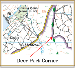
From the above example it could be assumed that at some point in time there was an enclosure for deer somewhere near the location of the wall corner. In fact this is exactly the case as at one time the wall was a corn ditch belonging to nearby Willandhead used to contain deer, (Hemery, 1983, p.752). In some cases the naming of a corner has been a recent event, for example there is a road junction on the edge of one Dartmoor village at which is a grassy area known affectionately by the locals as ‘Shit Corner’. The logic behind this is quite simple, there is a narrow lane with a steep bank leading from the village to the junction and when people take their dogs for a walk this is the first piece of level grassland the dogs encounter which makes it an ideal spot for them to have a dump, this results in numerous piles of dog mess hence the name ‘Shit Corner’. If you mention this name to any local they will immediately know where you are talking about which saves time having to say the piece of grass at the junction of such and such lane with the so and so road.
Below is a list of corners that I have found in various books, maps and documents:
| Name | OS Grid Ref. | Name | OS Grid Ref. | |
| ALLACLAUNS CORNER | SX 5198 8130 | L CORNER | SX 7250 7833 | |
| AUSEWELL CORNER | SX 7333 7264 | LAWNS CORNER | SX 5629 7074 | |
| BARREN CORNER | SX 7125 7110 | LEG O’ MUTTON CORNER | SX 5177 6790 | |
| BATTEN’S CORNER | SX 4745 8123 | LENISDON CORNER | SX 6860 6598 | |
| BATWORTHY CORNER | SX 6590 8628 | LONG-A-TRAW CORNER | SX 6815 6468 | |
| BEARDOWN NEWTAKE CORNER | SX 5922 7835 | LOWER HUNTINGDON CORNER | SX 6670 6650 | |
| BEATLAND CORNER | SX 5482 6240 | LOWER PILES CORNER | SX 6420 6090 | |
| BEL TOR CORNER | SX 6950 7312 | LYLE’S CORNER | SX 5388 8820 | |
| BLACKLAND CORNER | SX 6278 5938 | MATTIN’S CORNER | SX 6660 6660 | |
| BLOODY CORNER | SX 73?? 90?? | MAY’S NEWTAKE CORNER | SX 6350 7015 | |
| BRAKE CORNER | SX 7020 7163 | MILL CORNER | SX 5920 6650 | |
| BROADMOOR CORNER | SX 5360 7823 | MOUNT MISERY CORNER | SX 6355 7060 | |
| BUDDLA CORNER | SX 5291 8164 | NEW FOREST CORNER | SX 5658 7640 | |
| BULLAVEN CORNER | SX ???? ???? | NEWBRIDGE HILL CORNER | SX 7080 7118 | |
| BURROW CORNER | SX 7360 7522 | OUTCOMBE CORNER | SX 5833 6830 | |
| CATS’ CORNER | SX 5765 6672 | OWLEY CORNER | SX 6700 5975 | |
| CENTURY CORNER | SX 6435 5922 | PEAS CORNER | SX 5339 8168 | |
| COUPLES CORNER | SX 7452 9045 | PIGS LEG CORNER | SX 528? 891? | |
| CROWN CORNER | SX 6790 7544 | PILES CORNER | SX 6475 6214 | |
| CROWN HALL CORNER | SX 6532 8529 | PRESCOMBE CORNER | SX 5219 8343 | |
| CUCKOO BALL CORNER | SX 6595 5821 | RUNDLESTONE CORNER | SX 5760 7497 | |
| DALE’S BRAKE CORNER | SX 6901 7441 | SENTRY CORNER | SX 6469 9180 | |
| DAW’S CORNER | SX 5629 7074 | SHEEPFOLD CORNER | SX 6230 7090 | |
| DEADMAN’S CORNER | SX 7055 7046 | SKAIGH CORNER | SX 6338 9334 | |
| DEER PARK CORNER | SX 6772 8407 | SOUTER’S CORNER | SX 5721 9182 | |
| ENDSWORTHY CORNER | SX 6620 8980 | STANNON NEWTAKE CORNER | SX 6470 8130 | |
| FRENCHANGERS CORNER | SX 7393 7796 | STOUTER’S CORNER | SX 5721 9182 | |
| FULLAMOOR CORNER | SX 5158 7200 | STUMBLE CORNER | SX 6948 7268 | |
| GIPSY CORNER | SX 7917 7884 | STUMLEY CORNER | SX 6948 7268 | |
| GLASCOMBE CORNER | SX 6626 6097 | SUNNY CORNER | SX 6091 6990 | |
| HALIFAX CORNER | SX 5550 7510 | THORNWORTHY CORNER | SX 6612 8541 | |
| HALSTOCK CORNER | SX 6038 9255 | THREE CORNERS | SX 7991 7890 | |
| HARTOR CORNER | SX 6020 9194 | TORDOWN CORNER | SX 5240 7528 | |
| HATCHWELL CORNER | SX 7051 7760 | VELLAKE CORNER | SX 5560 9037 | |
| HEATHERCOMBE CORNER | SX 7245 7184 | VIDLIN’S CORNER | SX 5482 6240 | |
| HIGH HOUSE CORNER | SX 6051 6295 | VIGER’S CORNER | SX 6799 6470 | |
| HIGHER HECKLAKE CORNER | SX 5360 7345 | VINNEY CORNER | SX 5758 7059 | |
| HIGHER HUNTINGDON CORNER | SX 6645 6802 | WARREN CORNER | SX 5135 7336 | |
| HONEYPOOL CORNER | SX 6587 8965 | WATER OAK CORNER | SX 6860 6598 | |
| HUNTINGDON CORNER | SX 6645 6615 | WESTERN CORNER | SX 6425 7460 | |
| HUXTON CORNER | SX 5498 6298 | WHITEHILL CORNER | SX 5790 6185 | |
| KELLY’S CORNER | SX 6038 9255 | WHORTAPARKE CORNER | SX 690? 709? | |
| KINGSHEAD CORNER | SX 7095 7695 | WILDBANKS CORNER | SX 6192 8041 | |
| KLONDYKE CORNER | SX 5940 9398 | WOOD CORNER | SX 7835 9142 | |
| KNOCKING MILL CORNER | SX ???? ???? | WOODMAN’S CORNER | SX 5275 6845 | |
| LANDSCAPE FEATURE NAME | PERSONAL NAME | |||
| MISCELLANEOUS NAME | UNKNOWN NAME | |||
| ENCLOSURE NAME | LOCATION NAME |
As can be seen from the above list many of the corner names refer to personal names or nearby landmarks such as farms, enclosures or landscape features, however there are a few which have an interesting story to tell. For instance, Bloody Corner is so called because an horrific murder took place at a cottage near to the spot. Brake Corner is on the one-time private road known as Dr. Blackall’s Drive and is at a point just before a sharp bend in the track, it is here that any horse and carriage using the road would need to slow down the team in order to negotiate the bend. Century Corner can be found on the edge of Harford Moor and derives its name from the word Sanctuary which indicates church land. Deadman’s Corner can be found near Holne and refers to a spot where an enclosure wall forms an acute angle. Presumably at some point in time a corpse was found near here? Gypsy Corner is located to the west of Bovey Tracey and is a road junction where at one time gipsies would camp. Klondyke Corner is a sharp bend in the road that leads up to Okehampton Camp and takes its name from the nearby house called Klondyke so sadly no gold will be found here. Mount Misery Corner denotes a corner of a wall which encloses a newtake known as Mount Misery. Peas Corner can be found near Willsworthy and is so named because a cart load of peas was once upended there. Mattins Corner is an alternative name for the small ruin once used by Keble Martin as a chapel whilst camping on the moor. Sunny Corner can be found just below the Devonport Leat near Nun’s Cross Farm and is a wall corner of Fox Tor newtake. Presumably the name refers to the favourable aspect of the location when the sun is shining? Several corners take their names from the shape the angle of the road or wall describes, these include L Corner, Leg O’ Mutton Corner and Pig’s Leg Corner. As previously mentioned, many of the corner names refer to a structure that once stood nearby, these include; Burrow Corner, Knocking Mill Corner, Mill Corner, Sheepfold Corner and Warren Corner. On a final note, I will leave the explanation of Couples Corner to your imagination?
Reference.
Crossing, W. 1993. Crossing’s Guide to Dartmoor. Newton Abbot: Peninsula Press
Hemery, E. 1983. High Dartmoor. London: Hale Publishing.
Soanes, C & Stevenson, A (eds.) 2003. Oxford Dictionary of English. Oxford: Oxford University Press.
Hi Tim, I came across Sunny Corner, mentioned in Hemery’s book, High Dartmoor. His description is very confusing but I think it is about sx 60888 70696. A possible addition to your list…..
Many thanks for such a great resource.
Thanks Kate,