 Legendary Dartmoor The many aspects past and present of Dartmoor

Just after Easter we rented a cottage at Holwell Farm in order to pick up some photographs for this website and to partake in a bit of moor rambling. As I had not set foot in anger on Dartmoor for a good eight months it was prudent not to be over ambitious. One of the Xplorations I wanted to do was the walk from Top Tor to Buckland Beacon and try to find some of the Buckland Commons boundstones along the way. One of the most informative publications on the Buckland bounds is a small A4 transcript by Mike Brown called ‘The Bounds of the Commons of Buckland in the More‘ written in 1698.
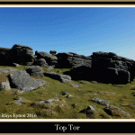
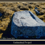
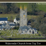
As Easter was early in 2016 it meant the Dartmoor weather could be anything from snow to sun and every possibility in-between. The previous day had been cold, very windy with heavy hail and rain storms much to everyone’s disappointment. In contrast the day we set out for Top Tor gifted us with blue skies and a quite acceptable temperature of about 12º C, ideal walking weather. So having arrived at Hemsworthy Gate car park we kitted up, (our party consisting of Angela, Louise, Holly, Rhys and myself) and set off up to Top Tor. There is nothing remarkable about the tor itself but the panoramic views from the summit are stunning. The tor does have a famous literary connection through the books of the authoress Beatrice Chase, aka Katherine Parr. In many of here books she has given some of Dartmoor’s landscape features pet names one of which was a tor she called ‘Dream Tor’. She never actually said which tor she was alluding to but I think it was Top Tor as can be seen from my Dream Tor page. If this is the case then rather fittingly her grave in the churchyard at Widecombe-in-the-Moor looks out onto Top Tor and can be clearly seen from it’s summit as can be seen from the photograph below. Another small feature that can be found on the tor is a granite boulder which seems to have been some ‘project’ or another of a stone cutter. By the looks of it the intention may have been to fashion a trough and for whatever reason the mason decided not to complete his work. There are numerous such part finished granite ‘projects’ scattered around the moor and one often wonders what made the various craftsmen abandon their work?
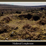
Having left Top Tor the route then took us above the prehistoric settlement of Foale’s Arrishes over to Pil Tor and down to Blackslade Ford. Just before reaching the ford we found two granite posts into which had been cut a square recess which at one time clearly contained a notice of some sort. Nearby were the obvious vegetation covered remains of a low wall, both walls and granite posts were a mystery. Having returned and done some research it appears that the walls are what is left of a medieval longhouse and the granite posts once contained a notice pointing this fact out and asking people not to trample over them, (thanks to Adrian Partridge for this information via the Dartmoor Information Exchange Facebook page). According to the English Heritage Pastscape Record (Monument Number 445165) the longhouse comprised of three rooms along with a cross passage and porch measuring 60ft x 14ft. They also suggest that quite possibly the remains are that of the Blackslade which appears in the Domesday Book.
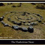
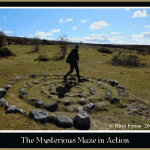
Just across the ford and up the Tunhill track on the right-hand side can be found a modern mystery in the form of a circular spiral maze constructed of small rocks. Very little, if anything can be found about this feature like as to who put it there, when and why? It was certainly in-situ and well established in 2010 as is evident from Keith Ryan’s photograph on his DartmoorCam website.
Having crossed the ford the search for the boundstones began in earnest, having done this exercise many years ago I can remember the difficulty in finding them amongst the thick stands of bracken. So it was quite a relief to see that much of the common had been recently swaled which would make locating the stones so much easier. Yeah right, famous last words, the first stone on the list was the ‘Crooked Stone’ whose top was just poking out above one of the thickest gorse stands imaginable. As can be seen from the photograph below there are no lengths one has to go to in order to get THAT photo. Just to make things worse, having waded thigh high through the gorse and found a spot where it was possible to photograph the blessed thing my camera decided to play silly buggers and pack up. That meant scrabbling even lower amidst a wall of gorse pickles to get a half decent picture, I think given the choice of that or shoving a hedgehog down my trousers I would have opted for the poor hedgehog. Having extracted myself, tattered, torn and bleeding from the gorse I realised we had missed the first stone which luckily was not too far away. This stone was incised with the letters; EPB1837/A/B and in various boundary surveys had been known as Culver Burrough in 1683 and Buiscate Burrow in 1613. With regards to the name it could well be that the ‘Culver’ element alludes to a Culverhouse this being another term for a Dovecote. Brown suggests that this connection comes from it possibly once was the name of the old Newhouse Inn which once stood just to the east of the stone. Alternatively it may have been that there once was an actual Dovecote located at the inn. p.18. As to Buiscate Barrow I will leave that to your imagination?
Two things here which are applicable to many of the boundstones that follow; firstly EPB stands for Edmund Pollexfen Bastard. The Bastard family purchased the manor of Buckland in 1614 and in 1837 this series of boundstones were set up by Edmund Bastard, hence the 1837 inscription. Secondly many of the boundstones were set up on prehistoric cairns or barrows hence the reason some of them are called either borrough, barrow or borrough. There are many instances country-wide of boundary points being located at or on prehistoric ritual features. Clearly these features would be visible in the landscape and their significance would have been passed on through the ages. Additionally that such prehistoric ritual features also acted as territorial markers which in a way is not that much different from denoting land ownership boundaries. Finally the inscribed letters A and B denote where the bounds of Ashburton and Buckland correspond.
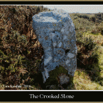
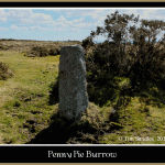
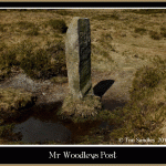
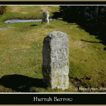
The next stone on the line was that known as the ‘Crooked Stone’ in 1613 and Bun Burrow in 1837 and was simply inscribed with the letter A and B. As can be seen from the photograph below it does not take too much imagination to see why it was called the ‘Crooked Stone’. As to where the ‘Bun Burrow’ came from is anybodies guess. Our next port of call was to what was called amongst other names Pennypowls Borrough in 1721 and Penny Pie Burrow in 1837, his one was incised with the letters EPB1837/A/B. Again it is hard to determine where any of the names appeared from, it could well be that Penny Pie has just mutated from Pennypowls? The next stone sentinel on our tick-list was known simply as ‘Long Stone near Chagford Way’ in 1698 and later became ‘Mr. Woodley’s Post in 1837. Unlike all the other stones this was was inscribed with the letters PW/1746 denoting Philip Woodley, it was his family who sold Buckland Manor to the Bastards in 1614. The family however kept the adjoining manor of Halshanger hence this particular boundary stone.
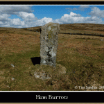
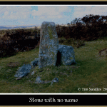
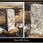
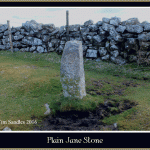
The last stone on this section of the route was named Hoar Burrow in 1683 and ending up as Ham Burrow in 1837, once more this is inscribed with the letters EPB/1837/A/B. As the name suggests this too is set upon a prehistoric cairn. At this point the car park adjacent to Cold East Cross is a stone’s throw away and if you have two cars an ideal place to leave one of them, the other being left at Hemsworthy Gate. The next stone has no official name and once again is marked with EPB1837/A/B and is located on Ham Hill so for convenience I have called it the Ham Hill Stone. Once again it was located on the remnants of a cairn. Very close to that stone sits another ‘Stone with no name’ which once again is situated upon an ancient cairn. For some odd reason this one is incised with the letters EPB/A/B and is missing the 1837 date, the only one like it in the series? A short distance away was another nameless stone this time with the full complement of inscribed letters; EPB1837/A/B. Close-by sits not only a stone with no name but a stone with no inscription, what one could describe as the ‘Plain Jane’ of the series. The last of our ‘stony’ objectives was the stone known as Two Burroughs in 1613 and Hen’s Barrow in 1837 but sadly I seem to have lost the photograph of it.
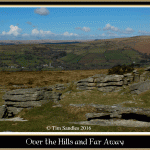
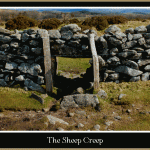
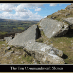
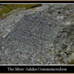
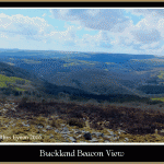
On a clear day such as we were lucky enough to experience the views from Hen’s Burrow are virtually 360º of wide-ranging breathtaking beauty and well worth the effort of arriving here. For a large part of this route we were accompanied of the enclosure walls of Welstor Common which one cannot help thinking the huge effort that went into building them. Just by a small stand of Scotch Pines can be seen a fine example of a ‘Sheep Creep’ albeit blocked up nowadays. The idea of these was to let smaller animals such as sheep to pass from one enclosure to another whilst stopping cattle and ponies doing so. Finally we arrived at the terminus of our walk in the guise of Buckland Beacon upon whose rocks more superb vistas were to be seen. To the west of the beacon Princetown and its prison can be clearly seen, to the east(ish) Teignmouth and to the north (ish) Haytor, Saddle tor etc. The main attraction of the beacon is the presence of the ‘Ten Commandment Stones’ and judging by the number of people there is a point of popular pilgrimage. In 1928 Parliament rejected a proposal to adopt a new common book of prayer and to celebrate this one William Whitely of nearby Welstor commissioned a Mr. W. Clements to carve the Ten Commandments on two boulders located on the beacon. In fact he commissioned eleven commandments because on the second rock there was a noticeable blank space after the original commandments had been carved. Unfortunately as can be seen from the photograph below the wording is hardly readable today despite being re-carved in 1995. For more on the stones seen my Ten Commandments page. Just above the stones can be seen another commemorative slab, this time marking the fact that during the Queen’s Silver Jubilee in 1997 the location was part of a chain of beacon fires were lit to celebrate her reign. Similar beacons were lit there as part of a chain in 1887 to commemorate Queen Victoria’s accession to the throne and again in 2002 to celebrate Queen Elizabeth’s Golden Jubilee.
Having completed the route we all met up at the Cold East Cross car park where my car had been left and rather than retrace our walk back to Hemsworthy Gate travelled back the easy way. It was agreed that after such a splendid walk the icing on the cake would be a beer or two and so we trundled down to Widecombe-in-the-Moor and paid a visit to the Old Inn. Now anybody who knows me will be aware that I do like the odd pint or two and my favourite beers are the Badger beers which Hall & Woodhouse produce. So I cannot say how delighted I was to see that the Old Inn is in fact one of their pubs serving some excellent ale. Now you may wonder why I have put a link to the Old Inn, well it’s a case of ‘one good turn deserves another’. Not only do I like the occasional pint at home but I also like drinking whatever brand out the relevant branded glasses. Much to the annoyance of my wife many of these glasses seem somehow to mysteriously make their way home, and the only brand missing from my collection is a Badger Ales one. So imagine my excitement when the beer at the Old Inn was served in such a glass, it did not take Angela long to see my eyes light up and even less time to get her infamous ‘witch’s warning’ which clearly said you are not making away with that glass. However, when one of the staff brought our food (excellent it was too) she asked if we could buy one of the glasses, buy one, buy one, what the hell. The waiter went away and returned with the devastating news that we could not buy one, however he presented a Badger Beer goblet and said I was welcome to take that instead, and get this, free of charge. So having proved in this instance that honesty pays I have now returned the favour and placed a link to the pub’s website. I will also add that the food and ales were that good we returned on several occasions during our holiday and can be thoroughly reccomended.

Brown, M. 19?? The Bounds of the Commons of Buckland. Plymouth: Dartmoor Press
Additional Reading
Brown, M. 1993. The Bounds of Buckland-in-the-Moor. Dartmoor Magazine – No.33, pp. 10 -13.
Brewer, D. 2002. Dartmoor Boundary Markers. Tiverton: Halsgrove Publishing.