 Legendary Dartmoor The many aspects past and present of Dartmoor

Place-Names – Toponymy: the study of the origin and history of names, and in this case the words that make up place-names. In some circles the word ‘Toponym’ has replaced the word -place-names. I find this a fascinating subject and often when driving around I come across a strange village name I try to establish how the name came about. Probably their importance is very much overlooked today but just think where we would be without them. Every journey has a destination and in order to reach there we need the name of the place we need to get to. Yes, most places also have a postcode which for instance when using a sat-nav can replace the actual place-name. However. if ever you were describing a place, for whatever reason, the chances are you would never refer to the postcode, you would use the actual place-name. For instance if I said that I had been to PL20 the chances are you could not picture the place. But if I said that I had been to Princetown you may well have a vision of the Dartmoor Prison or some other memorable picture. If you had never been to Princetown then at least you would have a chance of finding out where it is.
But what about features in the landscape such as on Dartmoor the ‘Grey Wethers? Again if you knew what they were you would have an image stored in your mind’s library of two prehistoric stone circles. Should you have never been there then at least you could research the name and come up with a location. In some cases it’s possible to get a mental image from a place-name without even having to have been there, for example – Beacon Hill. This may well conjure up a high vantage point on which there was/is a signal beacon, Gibbet Hill could have been somewhere once stood a hanging gibbet, etc. etc.
Certainly in the case of navigation they are an important factor, just look on any map which brings us onto a problem as far as place-names are concerned. There simply would not be enough space on any map to locate and name every landscape feature so many get left off and in many cases then lost for ever. It is amazing when looking at a modern OS map how many have been either lost or never considered important enough to name. The OS people must have a devil of a job deciding what features to name on their maps and what to leave off.
So my objective is to mark every Dartmoor place-name I come across and can definitely locate. There are two approaches to this task, firstly I have a Microsoft Excel Speadsheet which lists all the names I have come across, where possible their grid reference and a classification along with any notes – see below. To date this ‘gazetteer’ contains 9,255 entries of every place-name I come across.
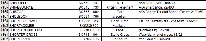
When I first started this spreadsheet I also numbered all my Dartmoor books etc and then added the relevant book number and page number for where I found the name. Basically this was because if I ever needed to find the source of a name again I new exactly what book to look in and on what page. For instance if I ever wanted to find Shirwell I would have known that book 218 was Eric Hemery’s ‘High Dartmoor’ and the name was on page 530. Also, with many Dartmoor place-names some have more than one name which is associated with a landmark feature. As can be seen below, Sheeps Tor has also be known as Shepys Tor and Shistor so in cases like these I add all the names and back reference them
You may notice that I say “would have known,” this is because I lost the spreadsheet which had all the publication references due to a crashed computer. Now apart from the few popular books I have no idea what book the numbers refer to – years of toil gone down the drain or rather banished to somewhere in the ether. This brings up a vital point with any such reference material – always have a back-up where possible.
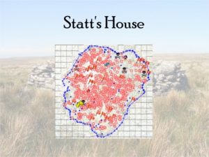
Having a ‘gazetteer’ of place-names I initially with help of a very fine pen marked them on an OS 1:250,00 Explorer map. But, what with the continual folding and unfolding of the map it soon became worn and eventually it fell to pieces – again years of toil gone down the Swanee. Then came the digital map era and what a god-send that was as it meant I could log every name anywhere on the Dartmoor map. Not only that I could plot routes, measure distances and even print off extracts whenever needed. Therefore it did not take long to transfer all the names from the gazetteer which were not already marked. The programme I used was ‘Memory Map’ and the other advantage of this was that on each ‘mark point’ it is possible to add comments to each mark point. Now, what was the vital point mentioned above? always back up any data. And yes, you can guess what’s coming, on another computer crash I lost all the places which I had meticulously marked which meant back to square one. As you can see below, although not completely restored to full health there are many mark points on the new version. The illustration just goes to show how many Dartmoor place-names are not either included on the map or have been lost in the dim and distance past. It also serves to show how difficult a job the folks from the ordnance Survey have in locating place names and fitting them all on a map.
OK, that’s a brief outline of the actual place-names themselves but what about the question as to how they came about? The biggest problem here is that over the millennia Britain has paid host to many foreign peoples all with their individual languages such as Celtic, Scandinavian langues, Latin and French. Over time the various languages and their words were assigned to place-names which for Britain gave an eclectic mix of names. Therefore when looking at a place-name their may be influences from these languages which have overtime mutated to the modern versions. For example; Chittleford was first documented in the Assize Rolls of 1244 where it appeared as Chytilford. Since then the name has gone through very little change but as always its etymology is not quite what it seems. Clearly the second element ‘ford’ referred to a crossing place which forded a small tributary of the West Webburn. But the interesting element is the first one which derives from the Old English word – citel/cietel which means a kettle or cauldron. It has been suggested by the Place-Name Society that this alludes to a point where the stream bubbles like a ‘cauldron’ over which its forded. In basic terms place-names are made up of elements as demonstrated above and in most cases these elements can be a landscape feature as in a ford, tor, rock etc or the name of a person who once inhabited, frequented or owned a certain location such as Sammy Arnold’s Lane. Occasionally you can get a combination of both types of elements.
DARTMOOR – I would suggest that there is not a square kilometre on Dartmoor which does not have a place-name somewhere in it and this applies to the barren upland wastes. Well in theory that’s correct but if on an OS map you look for grid reference SX 57 85 you will see there is not a name in it to be found, however because of this fact it has become known in certain circles as ‘No Man’s Land’ – can that be classified as a legitimate place-name? Along with Dartmoor place-names comes a great hidden wealth of historic and traditional knowledge and insights into their past..
There are many ways to compile a gazetteer of Dartmoor place-names but I have found that by far the easiest are the two methods noted above. But where to start? sources for Dartmoor place-names are numerous (as is the same for the rest of the UK) and I would suggest the best place to begin with maps, both old and new – topographical maps, old estate maps, tithe Apportionment maps, estate agent’s maps and so on and so forth. For older maps there is an excellent website hosted by The National Library of Scotland which has a variety of free online OS maps which can be found – HERE. Then the next obvious source are books and magazines and probably one of the best is Mike Brown’s ‘The Gazetteer of Dartmoor Names’ (ISBN 0-9515274-7-9). Next is the two-volume ‘The Place-Names of Devon’ published by The English Place-Name Society (ISBN: 521 0758-5 and ISBN:0 904889 56 4) ) which also provides suggestions as to the etymology of the names. As mentioned above some place-names have at one time or other been influenced by foreign languages, many of them Anglo Saxon and Celtic and in the case of the former Clark Hall published ‘A Concise Anglo Saxon Dictionary’ (ISBN: 0-8020-6548) which is very useful.
There are numerous Dartmoor specific publications but I would suggest that those written by William Crossing, Hemery’s ‘High Dartmoor’ (0 7091 8859 5), Samuel Rowe’s ‘Perambulation of Dartmoor’ (ISBN: 0 86114-773-1) and Worth’s ‘Dartmoor’ (ISBN: 0-7153-5148-6) are the most informative. Some of these can be downloaded free from the Internet Archive as pdf’s which also provides a search facility for each book, see – HERE. Another publication although not Dartmoor specific is Ekwall’s the ‘Concise Oxford Dictionary of English Place-Names’ which again gives suggestions as the the origin of the names (ISBN 0 19 869193), again this can be downloaded free from the Internet Archive. Back copies of local newspapers are also a good source of Dartmoor place-names, especially the reports from the various hunt days. Here is such an example from April 1936. “commenced over Runnage Common and proceeded to Coal Mires to Landlake Mires… made for Whitmeads… onto Fuzzy Meads… passing Penlee… skirting Naked Hill… to Tuckett’s Drain.”
Another fascinating aspect of place-names are those of agricultural fields and enclosures and very often the names can reflect what purpose they were once put to. These can be found listed in the respective Tithe Terrier along with a map of the parish farms. Thankfully the Devon County Council have placed both map and terrier online for all the Dartmoor parishes, again a free resource which can be accessed – HERE.
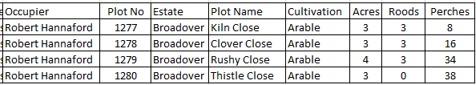
As can be seen above here there are four fields belonging to Broadover in 1840 which was in the possession of Robert Hannaford. All four in that year were growing crops of some kind and were deemed as ‘closes’. In these cases the field name alludes to what was being grown, as in Clover Close, the possibility that there was at that time a lime kiln as in Kiln Close. Rushy Close would suggest wet land where rushes grew and similarly where thistles thrived. There are two good books devoted to field names – ‘A New Dictionary of English Field Names’ (ISBN 978-0904889994) published by the English Place-Name Society. The other recommended book is ‘A Dictionary of Field Names’ written by John Field (ISBN: 978-0715357101).
The Dilemma – place-names is an ever evolving subject as there are always new place-names coming along for various reason and it’s just a matter of common usage before the name goes down on the record. On Dartmoor one of the ways this can happen is thanks to the Letterboxing community. A prime example how this can happen is Cut Hill, there are numerous landmark features on the hill such as an engraved stone, a flat boulder, a one-time rain gauge etc. Related letterbox stamp were sited from these landmarks and as more and more people visited them they soon became attached. So the engraved stone was incised with the letter J. E. W. and soon became known as ‘The Jew Stone’. When talking to fellow letterboxers and try to explain where a certain letterbox was sited one might say; “oh, its 40 paces from the Jew stone,” immediately in their mind’s eye they could picture the location. But in this case can this be regarded as a bone-fide place name? Another example is that recently on a Dartmoor group forum I saw a photograph of a small outcrop which was named ‘Whortleberry Rock’. The explanation being that when the photograph was taken there was a profusion of whortleberries growing around it. All this then needs is for people to keep using the name and before long that nameless outcrop becomes ‘Whortleberry Rock’.
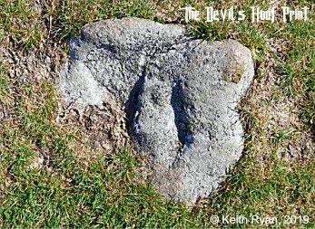
Again another very recent example can be seen on Keith Ryan’s Dartmoor CAM website, he took a photograph of a rock which had two hoof mark indentations on it which he christened as the ‘Devil’s Hoof Print’. As it is located on much frequented path leading to Buckland Beacon all it needs are for folk to see his web page and go in search of the ‘Devils Hoof Print’ and if enough people do so it would’t take much for the name to stick. So, just think how many times over the millennia has such a process taken place all it needs is good sense of imagination and enough folk finding it and then using it in one form or another.
There are numerous other such examples scattered all across Dartmoor some have been lost whilst there are new ones coming along. But again how old does a place-name have to be before it can be classified, should it be a name that has been in common usage for more than 10, 20, 50 or 100 years?
I will virtually say that every place-name has undergone over time a transformation from its original name to that of today. The main reason being that as many of them began life as a foreign language these then over the centuries have become ‘bastardised’ in relation to the local tongue. Much of this is due to the fact that when documented they can very very reliant on the interpretation of the local dialect and the literacy of the author. The prime example of this can often be seen in local newspaper articles where either the reporter has had trouble with dialect translation or the report has been subject to what today is known as ‘typos’ either by the author or the type-setter.
So there, in a very small nutshell is place-names, are they important, should old names simply be allowed to fade into insignificance, or where possible in one form or another be kept very much alive? I would suggest that yes they should due to the amount of hidden history, tradition and heritage that is attached to them. Can redundant place-names be resurrected today? yes they can if enough people start using them regularly enough.