 Legendary Dartmoor The many aspects past and present of Dartmoor

As you trundle up the B3212 road from Dousland to Princetown which many today refer to as the Peek Hill Road you’ll be confronted with another of Dartmoor’s enigmas. In fact this road was once referred to in certain quarters as ‘Goadstone Hill‘ and just to the right of the road is a small pool of water known as ‘Goadstone Pond/Pool‘. Additionally somewhere in the vicinity was/is ‘The Goadstone’ whose exact location has over the years caused some debate. But firstly what is the meaning of the Goadstone place-name? Here again we come across some slight confusion because as brewer points out; “Other references to the stone, whichever of the two (see further on) it might be, call it the ‘Goat’s Stone’ or Goatstone, and this is referred to in the census of Walkhampton parish for the year 1851…” – p.242. So is the place-name ‘Goat Stone’ or ‘Goad’ Stone? Assuming that the ‘Goad’ element is the correct one what does this word refer to? To find a possible answer to this one must look to the neighbouring county of Cornwall. Back in the 1800s a Cornish dialect expert recorded that a ‘Goad’ was a small area of land which could be measured by the ‘goad’ or staff which was used when driving oxen. Traditionally these measured nine feet and an area of two goads square represented a yard of ground. So if taken a ‘Goad’ denoted a small area of land what context could this take on Dartmoor? Dave Brewer wrote; “... in A. K. Hamilton Jenkin’s Cornish Miner (p.49) he quotes from an early writer in reference to marking bounds ‘Then make they the Goad or Rodd pard (pared by slicing off the turf) four square being in length or shortness according to the number of workers in this Goad… Hamilton Jenkin goes on to say Goad – a land measure. It represents nine feet, and two goads spare is called a yard of ground.” – p.241. So possibly there is a mining connotation to the word and again Brewer suggests that this connection would have been a boundary stone associated with the Walkhampton Clay Sett.
But then we come to the ‘Goat’ possibility, again Brewer has a possibility for this too when likening the ‘Goat’ element to that found both in the 1786 stannary bounds of Ashburton and Plympton. In the case of Plympton it was stated as; “Dunnagoat Stone in Wellake Lawe.”- p242. Also on northern Dartmoor are two tors with the word ‘goat’ appearing – Higher and Lower Dunna Goat, in this instance the English Place-Name Society suggest that the term ‘goat’ has been corrupted into the word ‘gate’. However, in all probability there never was a gate in the vicinity of the Goat Stone or it would have suggested the ‘Gate Stone’?
Then we come onto the next conundrum – where was the Goad/Goat Stone located? If you consult the most noted Dartmoor topographical writers once again there are two options presented:
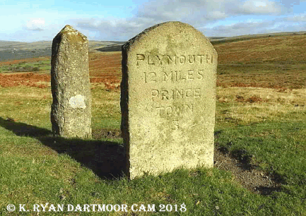
“Half a mile further on we reach the twelfth milestone from Plymouth. This is known as the Goad’s Stone, and on the upper half of the face are some markings, but they are not really distinguishable.” – Crossing, 1990, p.91.
“The Exeter road enters the Moor at Peek Hill, not far from Dousland, and is carried over the shoulder of that eminence. On its northern side, and on the left of the way in going to Princetown, is a stone, which may not improbably be one of those erected some two centuries ago by the Plymouth Corporation. It is known as Goad’s Stone, and marks the point where a green track, coming up from Walkhampton, joins the highway. It is of small size, and is usually regarded as being an old milestone; some faint markings may be traced upon it, but whether they are artificial is doubtful.” – Crossing, 1987, p.38.
“Crossing states that the third milestone from Princetown stands at the junction of the track from the Walkhampton valley (via Routrundle) with the highway, that it bears indecipherable markings on its face and was formerly known ad the Goad Stone. There is now no stone in this position, the present milestone is some way south of the junction and, other than functional incisions, bears no sign of ciphers.” – Hemery, p.108.
So it’s a case of ‘you pays your money and takes your choice’ but to let Dave Brewer have the final say: “The Ordnance Survey six-inch maps of the 1880s and 1906 both show the track from Walkhampton going directly to the milestone on its way to Stanlake, crossing the highway as Crossing describes it; it is only the more modern maps that show the track from Walkhampton joining the highway further west opposite Goadstone Pond, exactly where, the older, rough unmarked stone is sited! More confusion, but the author thinks that this is what must correctly called the Goadstone.” – pp. 214 -242.
It can be assumed that Goadstone Pond has taken its name from the actual Goadstone and apart from being a convenient source of water for the moorland cattle, sheep and ponies it’s other claim to fame is that it never dries up. However in the drought conditions of 2018 it certainly did dry up thus revealing its true depth – not very deep.

Brewer, D. 2002. Dartmoor Boundary Markers. Tiverton: Halsgrove Publishing.
Crossing, W. 1987. Dartmoor’s Early Historic & Medieval Remains. Brixham: Quay Publications.
Crossing. W. 1990. Crossing’s Guide to Dartmoor. Newton Abbot: Peninsula Press.
Hemery, E. 1983. High Dartmoor. London: Robert Hale Ltd.