 Legendary Dartmoor The many aspects past and present of Dartmoor

Ever since mankind reverted from hunter gathering to permanent settlement there was a need to define tribal lands. As time progressed the ‘lands’ became manors, parishes etc and there was always a need to claim the rights of ownership which distinguished these lands from their neighbours. On Dartmoor the first recorded record of laying out a land claim by means of certain landscape features acting as boundary points was the Perambulation of 1240 which marked the Forest of Dartmoor. In later years each parish would regularly carry out a similar exercise called ‘Beating the Bounds‘. The theory was that by getting as many parishioners to walk the stated boundary of their parish there would always be a living record of those bounds should a land dispute ever arise. Today records of these customary Beating the Bounds provide not only an insight into the actual event but also a wealth of long forgotten place-names and boundary markers that no longer appear on modern maps.
Revival of a Dartmoor Custom – The Totnes Times and Devon News, November 2nd 1895.
A resident of Ashburton came into possession of a paper from 1613 which was an account of the last beating of the bounds for that parish. In 1835 it was realised that this long-standing custom had not been carried out for 282 years. As the account of 1613 clearly laid out the various boundary markers of the parish of Ashburton it was decided to revive the tradition which entailed a walk of some 25 miles. This ceremony took place on the 22nd of October 1895 and was reported at great length in the Totnes Times and Devon News as follows:
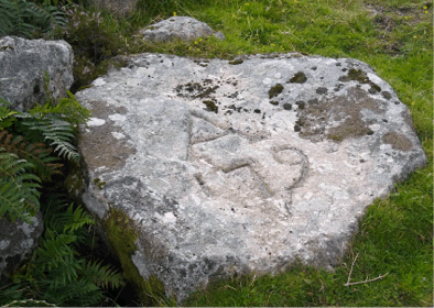
“At the appointed hour there was a goodly muster at the rendezvous,” amongst the muster were the town’s Portreeve, Baliff, members of the Parish Council, the local vicar thirty named parishioners, along with boys from the grammar school and some stragglers who caught up the procession at a later time. Before setting of the group; “received the hospitality of Mr. W. H. Mortimer, of the brewery, who kindly gave the party ‘summat warm’ to start the journey and on it would appear from the light of subsequent events that the refreshments so served were of such a character as not only to cheer the heart and oil the tongue but to elevate the spirits to the doing of doughty deeds. With commendable punctuality the party (first giving cheers for the Queen) started on their 25 mile trip, first of course beating the bounds against Staverton. Led by the Portreeve rhe railway was crossed and the river Yeo (Ashburn) through Stone Park was followed and followed to Gulwell Bridge through Gulwell Cottage garden, occupied by Mr. S. Lear, then through Mrs Westerway’s garden and over the high wall, necessitating a drop of about 15 feet and a wading through some 10 feet of mud and water. Here one of the special correspondents came to grief, finding himself travelling head foremost but he had the ‘fun’ pretty much to himself. Proceeding through Leat Park Garden, it was remarked – perhaps somewhat rudely – what a grand variety of plants were growing in that charming spot. Pursuing the river through Gulwell Meadows the pedestrains found themselves below Priestaford farm house where there were four boundstones, which naturally enough received a good deal of attention. These stones once marked the bed of the river Yeo but it was clear that the flow of the water had washed away several yards of land on the Staverton side, the Ashburton parish being benefitted to the extent of Staverton’s loss. Moving on, the company next came to Pridhamsleigh, and it was noted that from there the water found its way to Furzeleigh Mill. An obstacle shortly presented itself in the form of the Pridhamsleigh Bridge, under which it was necessary to go if the bounds were to be properly beaten, but there were three feet of water to be encountered! However, there were present men, and boys too, who were nothing if they were not thorough… When the waders emerged from their cold bath – for it was a bleak morning – they were not envied their dripping garments and their shivering lower parts, although their appearance was the signal for an outburst of laughter, it was devoutly hoped that they would not take cold. Passing on, the river was followed in its zig zag course through Furzeleigh estate, and it was remarked on all hands that something should be done to improve its condition. Coming to the railway bridge a mishap occurred to a well-known townsman and would be Parish Councillor, who had the misfortune to collide with a rail and as a result to suffer the discomforts of losing blood from a prominent organ located in the face. Gaining the highway leading to Totnes and entering a meadow adjoining, many walked around the sycamore growing at the extreme end of the parish and greeted it with a hearty clap of the hands, feeling – it may be superstitiously – that in saluting the old tree they were only doing their duty to the present and future generations. Thus terminated stage one of the bound-beating, the river Dart next coming in for attention as being the division of Ashburton from Buckfastleigh and Holne i.e., from Dart Bridge to Holne Bridge. As previously stated, many felt that no obstacle should be allowed to stand in the way of doing the thing properly, even should it involve wading through water up to arm pits. It was not long before there was an opportunity of testing their courage, for the river had not been followed up far when that noble structure ‘Dart Bridge’ presented itself, and so far from their being any hesitation, there was a rush to be the first to pass under… Leaving Black Rock House and the Quarries to the left, the Buckfast Mills and St. Mary’s Abbey grounds were reached. Here the Portreeve made a few pertinent remarks on the woollen industyr and its importance to the neighbourhood. He called for three hearty cheers for the ‘operatives and the industry’ and the work people who were just then breakfasting returned the compliment. At the moment the bell of the Abbey was issuing forth its sonorous call to the Monks, probably to some devotional; exercises. The water being turned into the mill leat much of the river above the footbridge to the weir was taken on the large worn stones that formed its bed and here Messrs Amery took the opportunity to point out the boring action of the water on certain stones which had holes in them. A fine view of the Abbey was obtained as the party pursued their way up the river. After a short pause at the weir the route was followed up to a little island situate right under Hembury Fort. It transpired that this island had recently been purchased by Mr. T. Wetherdon, and that it belonged to Ashburton parish, consequently it was necessary that it should be perambulated. (The island in question here is in fact called ‘Blackpool Island’ although its no longer marked on the modern OS maps). Now this meant wading through some feet of water, but, there were some equal to the occasion, and no little amusement they caused, the elders pulling up there unmentionables and taking the youngsters on their backs. One or two came in for a jolly good ducking and the before mentioned – would-be-Councillor was one of them. The Portreeve narrowly escaped but he got off with only a wetting of the edge of his garments, not the ‘gown’ which was left safely at home, and he was congratulated on his good luck by a hearty cheer. Next time the Dart will probably be navigated at this part, and boats will, no doubt be plying to and from Wetherdon’s Island (?) . It was stated that before time it was connected with the main land by a wooden bridge, and that charcoal was made there, by who by, or what for was information which was not forthcoming. Just above this point Mr. F. Amery called attention to the old workings of the mine known as ‘Queen Dart’ which once gave employment to many inhabitants of the locality. The site of the workings is just under Horsehill Farm house and White Rock (?) was seen at no distance to the right. Another disused mine known as South Plain (South Plain Wood Copper Mine SX736 703) was visited and the party passed onto Sandy Gate and under the middle arch of Holne Bridge. Here by the kind thoughtfulness and hospitality characteristic of all true Britons the Portreeve had a good supply of refreshments waiting and it is hardly necessary to say it was most welcome and a good breakfast was enjoyed, the hour being just ten o’ clock. The vicar of Ashburton and Mr. Hingston of Totnes, steward to Mr. B. J. P. Bastard, joined at this point. The health of the Portreeve was proposed and drunk with great gusto and in a few minutes all were again on the move, for time was precious, and the party were not in a fit state to do much loitering, as rain had been steadily falling all the time. Moving on in the direction of ‘Lover’s Leap‘, formerly called Landscove Tor, that romantic spot was soon reached, and being the point at which Buckland joins the parish, the Portreeve, by happy inspiration, proposed a vote of thanks to Mr. Bastard for throwing open his grounds to the public during the summer months, which was he said, the means of affording great enjoyment to a large number of people, and was a great kindness and benefit to the inhabitants of Ashburton in particular. Mr. Hingston, in the course of a suitable reply, said he thought he would promise on behalf of Mr. Bastard that what had been done in the past would be continued in the future. Some hearty cheers were given for the squire, and the company having inspected the bond stone, (SX 7267 7226) which bore the date March 4th 1837, then broke away from the drive and up through the wood by a stream towards Auswell first coming to a well called Muswell. Here was another stone dated May 4th 1837 (SX 7282 7231) . Attention was called to a large holly bush growing over the well and to the granite cross near by, all will be found in King’s Head Wood, (this is particularly interesting as I can find no reference to a granite cross at this location). By way of implanting this secluded spot in the boundary well in the minds of the rising generation some of the boys stood on their heads on the bound stone. From this point a wall forms the boundary to a stone called ‘Ashburton Church Key’ (also known as the Ashburton Stone at grid reference SX 7300 7240) which was not recognisable, however, on this occasion. Following on the boundary line passed slick through the ruins of the threshing floors of Auswell Farm, where many an old labourer has threshed corn in two parishes at the same time. The line runs diagonally S. W. to N. E. From here the company moved on to Threshell Stone (SX 7333 7264) on the highway and climbing up the hill a well called Stidwell was noticed. This spring is a most valuable one, supplying as it does Buckland, Welstor and Bowdely with water and it has the reputation of never failing. Keeping on the course the party next came to the stone on the top of the hill known as the Grey Mare (SX 7342 7301) it was not stated whether it was the ghost of Tom Pearce’s of Widdecombe Fair renown and although it was of ample proportions the youngsters who mounted it voted it rather uncomfortable to sit astride. There is from the road to the Beacon a stone wall sufficiently wide on the top to admit two persons walking abreast and this was done the more effectually to claim the boundary. Sleet and snow was now falling fast, so there was no lingering at this elevated spot and the company hurried on in the direction of Cold-east corner passing on the way some stones dated 1746. There was one however dated 1837 which was a pointer to several others. There was also a stone denoting a path which formerly led from Welstor to Buckland. The stones dated 1837 appear to have been placed there by an arrangement between the owners of the properties – Mr. Woodley, of Halshanger, and Mr. Bastard of Buckland – the stones bearing the initials B. and W. The forth stone in the row is dated 1746 and marked P. W. for Peter Woodley, (also known as Mr. Woodley’s Post SX 7394 7446) who built the Newhouse Inn on the road from Ashburton to Chagford, but which has long since fallen in ruins. Having inspected William’s Well and Blackslade Ford, the party pursued their way by a wall to Grey Goose Nest, which was reached at 12. 30. Snow was falling heavily and the air was so keen that it froze the wayfarers. Luckily, however, the hospitality of the Portreeve was again to the front, and an adjournment for luncheon was made to the ruins of Newhouse, which was the limit of the boundary against Widecombe. Many of these boundstones can be seen on the Top Tor to Buckland Beacon walk page – HERE
The meal was substantial and most timely, but it had to be taken under difficulties, owing to the severe weather which had the effect of driving home some who evidently thought discretion was the better part of valour. Not much of a stay was made and the company pushed on leaving Rippon Tor of the right, and mounting the hill, Nutcracker Rock so tenderly poised by nature’s builder, was observed. Following the stone wall the boundary led through a bit of marshy ground or bog of about half a mile in extent in which there were a few mishaps, one lad sinking to a considerable depth but being pulled out he followed on again with great pluck and endurance. The party now neared a portion of the boundary where, in a field known as Lower New Park, belonging to Halshanger, the hedge at the higher end of the field belongs to Islington whilst the lower portion is in the parish of Ashburton, the boundary being about 30 yards below the stile at the division of the two fields on the Ashburton side. Enphasis was laid on this fact by Messrs Amery and supported by Mr. Randell, bailiff, to Mrs Woodley of Halshanger, who acted as guide to the party through the estate. A look at the extensive saw mills of Mr. Bowerman, of Dawlish, who is clearing a plantation there, and the company made off in the direction of Owlacombe, following the stream thither from Langford Bridge and proceeding from Owlacombe to Hook’s Cottage, the route by the way, leading direct through the mine (Owlacombe Tin and Arsenic Mines). At Hooks, Mr. E. Tucker kindly provided refreshments and after thanking him for his hospitality the company followed the little river lemon through the wood to Owls Rattle (?). At this point one of the company met with a misfortune, and damaged his nether garments which caused him endless anxiety thereafter, but which also caused the juveniles a corresponding amount of amusement. Keeping in tough with the Lemon the company arrived at Lemon Bridge, under which many went, not without sundry casualties, resulting in some more gratuitous ‘duckings’. At the corner of an orchard is the hedge that divides Islington from Bickington, and standing in Ashburton parish the corner of the hedge marked the boundaries of the three parishes. The Bickington Flock Mill, (SX 794 726) with its overshot wheel going its steady rounds, was duly observed, and the business of the day was pursued, and a meadow near the ruins of Lemonford Mill (SX 798 719), burnt down a few years ago was visited, but the bond stones there were past identification (SX 796 720), consequently a note was made that the Parish Council should give the matter attention. It appeared that on entering the meadow at the higher end the line would strike away to the corner of the orchard wall, then down through the middle of the orchard, over the hedge and into the Newton Road. Having reached the road it was followed as far as the Smith’s Shop at Water (?) where for the third time refreshments were provided by the Portreeve and whether the appetite was keener of the beef better the meal was best enjoyed of all. A short rest and the company are again on the move by the boundaries of Bickington and Torbryan, nothing of importance occurring until Combe Cross was reached. Passing through several fields on Goodstone grounds on to the top of Mead Hill Cross where the highway divides the parishes of Ashburton, Torbryan and Woodland, a stone indicates the division of the three parishes and the Portreeve was careful to have this noted (?). Following the highway into Great Sanctuary across the road to Higher Barn estate the top of Whistley was reached and a halt was made for the purpose of viewing certain bond stones , one of which has been shifted from its original position, causing a loss of about three yards of land, a hint being dropped that the Parish Council should see to this also. From the top of (?) Mr. Grosvenor Berry led on the now tired out party to Chuley pond and by the stream to Chuley House thence to the point from which the party started in the early morning. The round was now completed and, falling in, the company marched in procession to the Bullring, where the Portreeve thanked them for their attendance saying he was glad to see so many had gone the whole round. Mr Amery proposed a vote of thanks to the Portreeve for his great kindness and called for three cheers for him which was lustily given and the party then dispersed having had an enjoyable outing in spite of the rough weather. Thus terminated an interesting event and the Portreeve and jury are to be congratulated on the complete success of an undertaking, which none of their predecessors had attempted for nearly three centuries.”
Although many of the places named above no longer appear on modern-day Ordnance Survey maps it is still possible to follow Ashburton’s parish boundary on an early OS map which can be found online – HERE.