 Legendary Dartmoor The many aspects past and present of Dartmoor

Of all of the tracks on Dartmoor the oldest is probably the one that runs from near Holne moorgate in the west to Cockle’s Gate in the east. Today the distance is about 7 miles but it may originally have been a mile or two longer. What marks this track as being special is that along its route there are 12 purposefully spaced moorland crosses which would have acted as waymarkers. The course of the track traverses the narrowest possible moorland tract and does not entail crossing any major rivers. The crosses could suggest a pre-Catholic origin which would date them and the track prior to the 1500’s and may have been a medieval ecclesiastical reminder for the traveller of their ultimate journey. They would also possibly provide some re-assurance to the lone pilgrim of some kind of holy protection whilst on the misty wastes of the moor. In the 19th century, William Crossing was instrumental in finding, repairing and re-erecting many of the crosses which stand today thus giving an insight to their purpose. The fact that the route avoids any major river crossing could also provide a clue to its age. It could suggest that travellers were using this track because there were no bridges built over the major rivers, i.e. The Dart. The first bridges to span this river were built sometime between AD1300 and AD1413 which again would point to a medieval origin for the track.
But where does the name of the track come from? In the 1600’s a man called Richard Stukey was a shareholder in several tin mines amongst which was one at Wenford. Some of the place-names appertaining to the limits of the mine included, “Hobbehole by Wenford, Maltern Waie above Wenford and Lower Maltern Waie.” Wenford is the old place-name for the modern Venford which is near to where the track starts and could just possibly suggest that the name of the track was the Maltern Way. Some think that the name has associations with Barley and could indicate that the ‘way’ was used for carrying barley seed or by-products?
The Maltern Way makes for an excellent walk that encompasses many of the historic features of Dartmoor and if done on a fine day allows one to appreciate exactly how beneficial the crosses would have been to a traveller in times gone by. Nobody can be certain that the crosses were re-erected in their original places but today from most of them you can see the previous and next ones along the track.
Depending on how high the bracken is the first point on the track is the remains of a medieval settlement at SX 68070 70550. It is thought that originally this is where the traveller would have left the enclosed lands by a moorgate. Nearby are two hawthorn trees that are supposed to mark the site of a now missing cross known as ‘Two Thorns Cross’ and a possible cross base is in-situ lending some credence to the theory. From Two Thorns Cross it is possible to see the first remaining cross on the walk on the skyline to the north-west, this is ‘Horn’s Cross‘ or ‘Stacombe Telling Place’. The latter name derives from the fact that at one time a farmer from nearby Staddicombe used to pasture his sheep with a moorman for the southern quarter of Dartmoor and it was at the cross that the sheep would be gathered for counting or ‘telling’ as it was called on the moor. (grid reference SX 66940 71090). From Horns Cross the next port of call is ‘Horse Ford Cross’ which lies close to the old Hooten Wheals mine track. This cross was restored by William Crossing after being found by a farm worker on nearby Down Ridge, later restoration work was carried out in 1972 after further damage which was probably caused by animals. (grid reference SX 66008 71355). The next cross in the line is ‘Skir Ford Cross’ and this lies about a quarter of a mile to the west of Horse Ford Cross. The restoration and re-erection of this cross was carried out in 1885 by William Crossing who clamped the two bits of the original together with iron bars. (grid reference SX 65533 71418). The track now swings in a south-westerly direction and climbs up onto Ter Hill which at a little over 1,500 feet is the highest point of the Maltern Way. On Ter Hill are two crosses known as the ‘Terrill Posts’ and they stand about 100 yards apart. The westerly of the two crosses is in fact a replica of the original one and was erected on the 21st of June, 1994. It is dedicated to Tom Gant, a well known Dartmoor enthusiast and author, as a nearby plaque will testify. The original cross can be found in the garden of the High Moorland Visitor centre at Princetown where it was moved to for its own protection. (grid references SX 64220 70700 and 64135 70635). From the Terrill Posts the way dips down to the next cross which is about a third of a mile to the west and is known as ‘Mount Misery Cross‘. Personally, this is my favourite of all the Dartmoor crosses, as it stands silently looking over the deserted farm below. Its enigmatic name is thought to be a field or enclosure name which alludes to the hard work that went into clearing the granite rocks and boulders. This cross was re-erected in 1885 by the instigation of William Crossing. (grid reference SX 63650 70590).

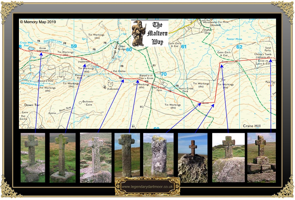

From Mount Misery the way now descends to the edge of Fox tor mires and Childe’s Tomb, upon which stands the next cross. (grid reference SX 62570 70290). The next cross is about half a mile to the west and is known as ‘Goldsmith’s Cross’. The shattered remains of the cross were found by Lt. Malcolm Goldsmith R.N. in AD1903 and repaired and re-erected, henceforth bearing his name. (grid reference SX 61805 70318). Marked on the OS map is another cross about half a mile to the south of Goldsmith’s Cross. Although this is strictly nothing to do with the Maltern Way it is a shame not to visit it. The stone, for that’s what it is, is called ‘The Headless Cross‘ or ‘Whealam Bottom Cross’ and is a simple granite pillar with an inscribed cross on its north-western face. It is thought that the stone is an old boundary marker for the southern and western quarters of the Forest of Dartmoor. (grid reference SX 61395 69505). Whilst on the subject of unrelated crosses, about 200 yards south of the Whealam Cross was what is purported to be the smallest cross on Dartmoor. It is known as the ‘Hand Hill Cross‘ or ‘Northmore’s Cross’. This tiny metal cross was made by a moor farmer called Bill Northmore from the propeller shaft of an old ship and was erected in 1980 in appreciation of Dartmoor. (grid reference SX 61328 69318). The one that sits on the boulder today is around the third replacement as the others were stolen. A mile to the west lies ‘Siward’s’ or ‘Nun’s Cross‘ which is probably one of the more noted of Dartmoor’s crosses. It is thought that the cross dates to Saxon times and was certainly mentioned as boundary mark called ‘Crucem Sywardii‘ in the perambulation of AD1240. On the eastern face of the cross the word ‘SYWARD’ is inscribed and may refer to man called Siward who prior to AD1066 owned estates at Willsworthy and Peter Tavy . The words BOC/LAND are inscribed on the western face and refers to ‘book land’ or lands held by charter. This in turn could be associated with Buckland Abbey, which as it was founded in 1278 would give another date for both cross and track. The alternative name of ‘Nun’s Cross’ is thought to have derived from the Cornish word ‘nans’ meaning valley. (grid reference SX 60165 69918). From Nun’s Cross the track headed westwards to the next cross which is about 300 yards away. Today, the easiest way to get to this cross is by following the leat which will lead to ‘Hutchinson’s Cross’. This modern cross is thought to sit in a socket cut into a boulder which predates to a much earlier time. It was erected in 1968 by Lt. Commander B. Hutchinson, R.N. as a memorial to his mother and is inscribed “S.L.H. 1887 – 1966. (grid reference SX 59913 69920). The route now heads in a north-westerly direction to the next visible cross which is ‘Newleycombe Cross’. This splendid old cross is situated amongst old tinners workings and was re-erected in 1915 by the Reverend Hugh Breton. (grid reference SX 59167 70290). The last cross on the original route is ‘Crazywell’ or ‘Classenwell Cross’ which stands to the east of Crazywell Pool. Again, Hugh Breton re-erected this cross in 1915 and only the head and arms are original. (grid reference SX 58380 70388). From Crazywell Cross the Maltern Way then heads in a west-north-westerly direction to a large, obvious boulder that is about 270 yards away. From here the track would have entered Raddick Lane and enclosed land. Today the lane leads down through the Raddick Plantation to Leather tor bridge and Norsworthy Bridge which is where you can leave your second car if you are not intending to retrace your route back to Venford. (grid reference SX 56882 69298).

Crossing, W. 1987 The Ancient Stone Crosses of Dartmoor, Devon Books, Exeter
Greeves, T 1998 The Maltern Way, Dartmoor Magazine No.51, Quay Pub. Brixham
Harrison, B. 2001 Dartmoor Stone Crosses, Devon Books & Halsgrove Pub., Tiverton
Hemery, E. 1983 High Dartmoor, Hale, London
Sandles, T. 1997 A Pilgrimage to Dartmoor’s Crosses, Forest Pub., Liverton
Starkey, F. H. 1989 Dartmoor Crosses, Starkey, Exeter.
Thanks for yet another meticulously researched and inspiring article.
We have walked this recently as the Monastic Way using Eric Hemery’s wonderful book “Walking Dartmoor’s Ancient Trackways” as our guide. Reading up on it since, I notice Crossing refers to it as “a green path of the moor” (“Ancient Stone Crosses”), Hemery calls it a “Monastic Way” and Starkey has it as “the Monks’ Path” (Dartmoor Crosses”).
By whatever name it is known, it is a truly evocative path, steeped in history, and an unforgettable experience. I was unaware that it was possible to walk across the width of the moor like this in a day, and I managed to sketch 7 of the crosses despite the temperature hovering around 2*C!
I have seen your book on the “Pilgrimage to the Crosses” referred to in the literature but cannot track it down. Can you point me in the right direction?