Amongst other claims to fame the small rock pile called Bottor Rock is arguably the most eastern of Dartmoor tors. The small pile can be found just south-west of the tiny village of Hennock and stands at a height of 793 feet. If you read most of the topographical Dartmoor books you will find barely a mention of Bottor rock but by compiling all the snippets, ancient traditions and legends slowly emerge. At one time Bottor Rock was believed to be by some an ancient and mysterious place of Druidical worship due to the presence of a ‘Stone Altar’ and therefore one that was regarded with much superstition. Not only did those prehistoric priests perform their various rites there but also the little folk of the moor, the piskies, dwelt among it’s many rocks and caves. So all in all it was a place best to be avoided at all costs. Today the only dwellers of the rock and surrounding woods is Old Brock the badger and his friends.
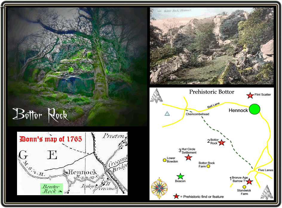
The first documentary record of the tor comes from the assize rolls of 1238 where it is written as Bodetorre, the place-name is thought to have meant, Botta’s or Boda’s torr. There is a suggestion that the origins of name means inhabited hill and whilst the name does indicate that the hill/tor was owned by Botta or Boda it is hard to establish whether he actually lived on it. Further documentary records show the name mutate thus: Bottetorre – 1306 (assize rolls), Bottorre – 1330 (lay subsidy rolls) and Westbottorre – 1414 (feet of fines. One of the earliest examples of Bottor appearing on a map was from Donn’s Map of Devon which was dated 1765 as depicted below:
A recent book on Hennock states there is a possibility that during prehistoric times people lived below the tor as there have been flint finds in the area of nearby Standwick. Around 200 pieces of loose flint were also discovered at Warmhill along with some Roman pottery. It also considers that at Bottor Rock Farm there were two concentric stones circles and that these were shown on the Tithe map of 1840 and were destroyed in 1842. However, the English Heritage National Monument Register lists four prehistoric features and finds in the area which are: 1) Possible Bronze Age round barrow, 2) Supposed ‘Idol or Stone Altar, 3) Supposed stone circle, probably Bronze Age/Iron Age enclosed hut circle settlement and 4) Neolithic flint scatter. These locations can be seen on the map below.
With regards to the possible round barrow Polwhele is his book ‘The History of Devon’ notes the following; “In a high field called Castle-Park, in Hennock, I met with a small earthwork, which is evidently sepulchral. The shape is elliptical: and its round is formed of small stones. The clergyman of Hennock, a short time afterwards, sent me the following account of it; ‘We opened the hillock that you suspected might be a Tumulus…” The problem here is that nobody seems to know where the field called ‘Castle Park’ was located apart from the fact that it was/is somewhere near Hennock.
Then we come to the supposed ‘Idol or Stone Altar’ , in 1852 J. G. Croker wrote the following: “On the west side of Bottor Rock is a singularly placed stone, described by W C Radly in 1841, as a huge rock idol or stone altar, with its fore foot supported by a wedge-like mass of the same older syenitic rock of which the whole is compose.” What was being suggested here was that the Idol or Altar held some kind of religious context more than likely to the Druids who many people in the 1800s believed to have worshipped on and around Dartmoor. If the 19th century antiquarians are to be believed then around the Iron Age there were Druids using Bottor for their rituals. Fraser, 2004, p.7, cites a comment from one such antiquarian called Davidson: “from its peculiar appearance and the Druidical relics immediately below it, is supposed to have been an object of worship as a rock idol”. The remark of Radley’s caused quite some debate with some people suggesting that the ‘Altar’ was a natural feature. One such opinion was reported in the local press of 1841, this read; “With respect to the huge Idol or Alar of stone at Bottor rock, whose fore foot is supported by a wedge-like mass of the same sienitic rock, it cannot be perceived that the Idol touches the wedge, as it is embedded on its sub-incumbent mass of Sienite. like its neighbours, several may be called idols, whose positions were not indebted to human agency.” In other words the author was saying that the supposed idol or Altar was not man-made and merely a natural rock formation and therefore held no religious significance.
Finally we come to the hut circle settlement, again J. G. Croker had this to say: “In a field called Brady Park, about 300 yards SW of Bottor Rock were two concentric stone circles. W C Radly, in 1841, gave the following measurements. Diameter of the inner circle 24 feet. Distance between the walls 18 feet. The outer wall was 4 feet thick and the inner stronger, wall 5 feet but much had been thrown away and about 3 feet remained. The area in the centre had been hollowed out. The circles were destroyed in 1842.” In 1978 an English Heritage Field Investigator visited the site and indeed identified an enclosure. In their opinion if this was the self-same feature as noted by Radley then it was either a Bronze Age of Iron Age settlement.
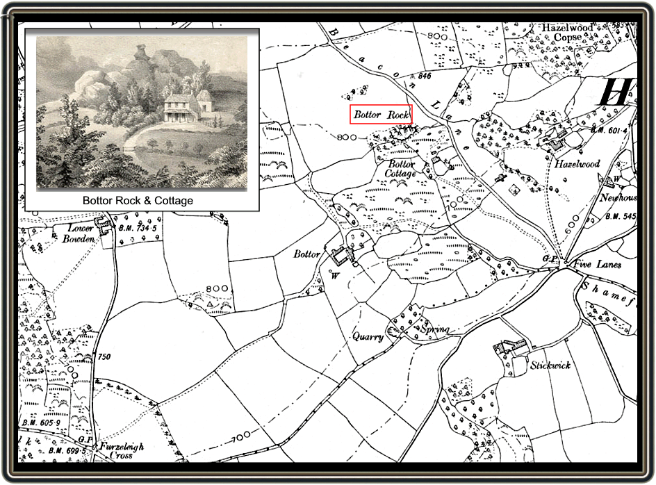
Whilst on the subject of historical landscape feature you can see from the old OS map that the lane running alongside Bottor is called ‘Beacon Lane’ which suggests that at some point in time a beacon of some sort was located nearby. The English Heritage Pastscape record suggests that a possible site for a beacon would be at grid reference SX 8245 8052 although documentary evidence and local knowledge cannot confirm this.
When describing the rock pile Crossing, p.301, notes, “… From this fine pile, the upper mass of which is sometimes referred to as Bottor’s Nose …”. This comment infers that the rock pile had been regarded as representing some form of human face, hence the ‘nose’. Another slight confusion concerning Bottor arises with a comment made by Sabine Bearing Gould, 1911, p.72 when he comments: “In the crevices of Bottor Rock in Hennock, Devon, John Cann, a Royalist, found refuge…”. Although there is some debate as to where exactly John Cann hid the general consensus of opinion is that ‘John Cann’s Rocks’ are in the nearby Furzeleigh Woods.
Lastly, Bottor Rock was or is depending on ones beliefs the haunt of piskies and legend tells of local folk often hearing them singing when passing the rock at night. Crossing, p. 301, clearly states: “The hollows in the base of Bot Tor Rock were formerly the haunt of the pixies, who have often been heard singing by the good folk of Hennock“. Locally there was a tradition that strange noises and music could often be heard coming from Bottor Rock. One farm labourer was adamant that on one Sunday morning he was on his way to church and that he was piskey led through the brimbles and over the rocks for a good two hours. Luckily some boys came by a told him to turn his pockets inside out which he did and was instantly released from the spell.

Baring Gould, S. 1911 Cliff Castles and Cave Dwellings of Europe, Seeley, London.
Crossing, W. 1990 Crossing’s Guide to Dartmoor, Peninsula Press, Newton Abbot.
Fraser, I. 2004 Hennock – A Village History, Sylverwood Publishing, Newton Abbot.
 Legendary Dartmoor The many aspects past and present of Dartmoor


Tim, we on our way up to Hennock today ~ October/6th/2018 and notice some large stones in a field to our right { we were coming up from Bovey} which lay about in the shape of a circle, there were a number of other outliers in the field, but otherwise the field was stone free. We pulled up and went back to have a look and I’d say that the site is undoubtedly prehistoric. Just ahead of where we parked the car was a lane that went off to Stickwick farm. Do you know anything about this site?
Cheers David
Sorry, I have looked on old OS maps, Google earth, Pastscape Records etc and can find no reference to the stones.