 Legendary Dartmoor The many aspects past and present of Dartmoor

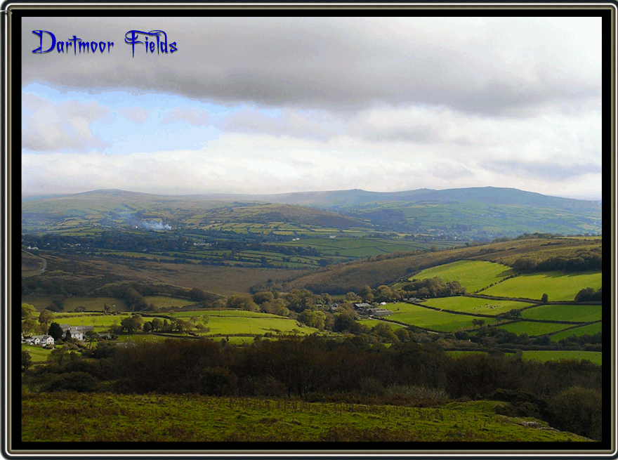
One thing that Devon and therefore Dartmoor are not short of are fields; big ones, little ones, recent ones, prehistoric ones, steep ones, and flat ones, they surround Dartmoor on all sides. Some are enclosed by hedges whilst others stone, all with the same purpose to delineate boundaries, keep stock in and in some cases keep stock out. Just about the only places on Dartmoor which were free from field incursions are the very high moors this is simply because for varying reasons farming was impracticable. In a way this has been a good thing as many of the archaeological features have not be destroyed to make way for agriculture and can still be seen today. What virtually each and everyone has in common is that somewhere they have a name. It could well be that over time the names have changed several times or in other cases simply lost because the original fields have disappeared and have been integrated to make larger fields. As with any place-names local dialects can drastically effect any modern interpretation and field-names are no exception. There was a field at Tor Farm near Poundsgate which the owners had for generations always called ‘Fried Bacon‘ which caused great confusion as to why. It transpired that from this particular field Hameldown Beacon could be seen which in the 1500s was a boundary marker known as ‘Fyerbicken’. This was due to the fact as it was and still is the location for fire beacons, centuries of dialect then changed the name from ‘Fyerbicken‘ to ‘Fried Bacon‘, Woods, p.63.
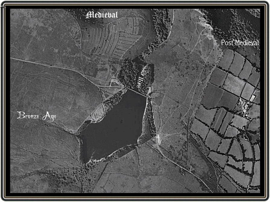
There have been defined ‘fields’ on Dartmoor which were used for specific purposes since the Bronze Age known as ‘reaves‘. Still visible today in the form of low, vegetation covered walls they clearly show where ancient man grew his crops and grazed his livestock. They also served as boundaries which marked out the various tribal lands that sprawled across the landscape. Who knows if back then they had names for each one but if they did these have been buried in the depths of pre-history. At times during the medieval periods farming moved up onto the higher moors and brought with it the medieval strip field systems. However, eventually the climate worsened and made farming impracticable and so such settlements as the one at Houndtor were abandoned. Meanwhile on the moorland fringes farms and settlements continued developing their field systems right up to modern times. If you are ever near Venford Reservoir take a look around for here you can see evidence of Bronze Age field systems along with those from the medieval and post-medieval periods as can be seen from the aerial photograph below.
Field names can give us a variety of glimpses into the past such as; who owned them, what crops were grown, the fertility of the soil, what landscape features were/are in or near them, their shapes, any changes in landuse and many other historical gems. In some cases the original field names have been adopted by the street names pertaining to the buildings that now stand on them. For instance, our house is next to ‘Badger’s Walk’ which was once a field that had a badger’s sett in it.
Very rarely will field names come up in common conversation unless one is specifically talking to the landowner but when they do it soon becomes obvious that almost every farmer will know the individual names of all his fields. In many cases these will have been passed on down through the generations. But what was/is the need to give each and every field a name? Basically for two main reasons; to identify land ownership and boundaries on legal documents and maps and where staff are concerned to direct them to specific places in which to work. For instance; “turn the bullocks out on Homer Meadow,” or “go and plough Barley Close,” etc. So where can these field names be found? As alluded to above many can be found on legal documents and maps such as old tythe maps and apportionments, estate maps, farming diaries, farm sale documents, deeds, topographical books and will inventories, many of which will be lodged with the local record offices and libraries.
Every county in Great Britain have their own names for types of fields and Devonshire is no exception some of which date back to Saxon times. For instance on Dartmoor the old Saxon open fields were known as ‘wares’. There are a few common generic names which often act as field-name prefixes or suffixes such as:
Arrish or Eddish – a field of stubble or aftermath of a crop, the prefix often indicating which crop it was.
Bottom – field located in or near to a valley floor.
Brake – uncultivated land usually found on the outskirts of a field system and are the last field butting up against the open moor.
Byes – normally the inaccessible corners of a field.
Cleave – normally indicates a steep, sloping field found on valley sides.
Close – land enclosed from former open fields.
Court – small enclosures into which livestock were driven for purposes of management.
Gore – triangular tract of land between two furlongs.
Gratner – fields that had been mown for hay or cereals.
Homer – fields near or central to the main farm.
Lairs or Lears – fields where livestock over winter.
Ley – grassland.
Mead – grassland normally mowed for hay.
Meadow – grassland normally mowed for hay.
Newtake – enclosures often 8 acres reclaimed from the open moor – see Newtakes.
Outer – enclosures further away from the main farm.
Park – normally refers to a small field or enclosure.
Plat – small field or enclosure.
Ware – Formerly an ancient open-field.
Waste – Unproductive land.
Yonder – enclosures further away from the farm.
Below is a map of field systems belonging to Lower Merripit farm in the 1840s along with their names. Here is a prime example of what can be learned of these fields in or before that period. For instance there is a small enclosure called ‘Uncle Bill’s Meadow‘ which would suggest that at one time he owned or specifically used it. Then there is ‘Soakfield‘ which suggests that this was very wet ground if not bog. ‘Square Fields‘ simply refers to the physical shape of the enclosures. ‘Big, Higher and Little Meadows‘ would have been fields set aside for hay crops. In a similar light ‘Higher and Lower Mead Park‘ would also have been hay meadows but slightly closer to the farm. As can be seen from the map, ‘The Brake‘ is located away from the farm and abuts onto open moor which means it probably was never cultivated. Then there are ‘Higher and Lower Coarsefields‘ which would allude to the fact that the fertility of the soil produced poor grass crops. Two interesting names that do not provide a definite answer as to their origins are ‘Leany Park‘ and ‘Vaglas‘. I would think that Vaglas is connected with peat in some way as a ‘vag’ is an old Dartmoor term for peaty turf found on the lower lands which was used as domestic fuel. Today the two ‘Leany Parks‘ are one field but it’s had to determine the meaning of ‘Leany‘, it may refer to the fields being very unproductive and would mean ‘lean’ times if relied upon? Alternatively the word ‘Lean‘ has derived from the old medieval word leyne which meant an arable enclosure.

The above is just one minute example of what can be learnt from field, newtake and enclosure names and Dartmoor must be covered with thousands of similar examples. Here are just a few of the more fascinating names I have come across;
Arrowhead Field – a field in which prehistoric flint arrowheads were found.
Bakes Park – fields which have been burnt to improve soil fertility.
Barrow Park – location of where a prehistoric barrow or hut circle once existed.
Bloody Meadow – filed in which a battle once took place.
Brandy/Brandis Park – a field shaped like a three legged triangular fire support known as a ‘brandis’.
Broom Park – field where gorse grew/grows.
Butter Park – productive pasture for grazing dairy cows.
Butts Park – previously the location of archery butts where the locals would practice their archery skills.
Cheese Meadow – field noted for good grazing for milk production.
Clam Close – field in which a clam bridge was/is located.
Cockle Close – field in which Corn cockles grew.
Conchies Field – field reclaimed from moorland by WWI Conscientious Objectors.
Eaver Close – a filed where rye grass (locally called ‘eaver’) was grown.
Fardel Field – forth share or part.
Four Aces – small garden fields forming the shape of 4 playing cards attached to the legend of Jan Reynolds
Granite Piece – probably a field with many granite rocks and therefore hard to cultivate.
Higher Pits – field in which or near to were old tinworks.
Honeybags – either where bee hives were kept or sweet grazing land.
Indigo Mead – refers to the colour of the soil.
Kennel Court – enclosure with dog kennels in it.
Mistress Piece – field at one time used or frequented by the ‘mistress’ of the farm.
Mount Misery – land hard to cultivate.
Newtake – an area of enclosed and reclaimed land.
Ox Eddish – where plough oxen used to be kept.
Rick Close – a field which contains a stack of corn or hay.
Roundy Park – a circular shaped field and if no longer circular this suggests a field boundary change.
Sentry Field – a corruption of ‘sanctuary’ denoting a field adjoining a churchyard.
Sheep Creep Park – field with a gap in the wall to allow sheep to pass through.
Shelson Ley – Derived from ‘shelf stone’ and indicating a cromlech.
Shippon Park – land containing or adjoining a cow shed.
Stack Field – filed in which hay or corn ricks/stacks were located.
Stroll Field – enclosure with a stroll (walled space between two enclosures) next to it.
Tongue Piece – a projecting field or enclosure.
Twitcheries – waste ground.
Winter Lears – a sheltered field used as a winter ‘lair’ for cattle and sheep.
Withy Close – fields in which willow trees grew.
Next time you happen to peer over a field wall or lean on a field gate to admire the Dartmoor views just think that every field, enclosure or newtake you can see has a name and that name will reveal some aspect of its past. It could be a modern part of its history or maybe one that stretches way, way back into the realms of yesteryear.

Bellamy, R. 1998. Post Bridge – Heart of the Moor. Tiverton: Devon Books.
Brown, M. ???? Walkhampton Field Names. Plymouth: Dartmoor Press.
Field, J.1998. 1989. English Field Names. Gloucester: Alan Sutton Publishing.
French. H. 1963. Field names in Widecombe-in-the- Moor. The Devonshire Association Report and Transactions XCV. Torquay: The Devonshire Press.
Hall, D. 1982. Medieval Fields. Princes Risborough: Shire Archaeology.
Muir, R. & N. 1989. Fields. London: Macmillan London Ltd.
Woods, S. 2003. Dartmoor Farm. Tiverton: Halsgrove.