“Over this old road very large quantities of peat were formerly annually conveyed on the backs of packhorses, as I have learnt from old men who at one time worked at the turf-ties to which it leads.” Crossing, p. 55.
Many moons ago the small moorland village of Peter Tavy was what could loosely be termed as a ‘distribution centre’ for peat which was extracted from the various turf-ties located on the high moor. From the village the peat would have been carried to local mines for fuel and to Tavistock market for domestic use. Hemery, p.199. It has been estimated that in 1800 a load of 100 peat turves would have fetched around 13 shillings which in those days was nothing to be sneezed at. Officially the old track starts its moorland course at Baggator Gate (SX 5463 8053) which today is where the lane coming up from Peter Tavy ends.
As always, why was it called Black lane North? Firstly any Dartmoor landscape feature that has the word ‘Black‘ in its place-name can refer to a couple of things depending on which author you consult. The general consensus is that it has an associated with peat as a moorland term for peat was ‘black wood’ due to the fact that ancient trees can often be found in the deeper layers of peat which have been stained black. In the case of Black Lane there certainly is a connection with peat as noted above. OK, so why the ‘North’ suffix? The simple answer is to avoid confusion as there is another Black Lane on the southern moor.
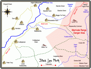
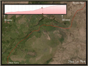
If you are feeling really energetic you can follow the route on which the packhorses would have made their journey by starting at Peter Tavy and climbing the 5 kilometres up to Baggator Gate which involves an ascent of some 178 metres. The road will pass through the hamlets of Cudlipptown and Wapsworthy on its journey before reaching the gate. Alternatively you can drive up to Baggator Gate and park up then follow the road along for about 1 kilometre before picking up the Black Lane North Track. From Baggator Gate the route passes through another moorgate known as ‘Roundwood Gate’, this was named after the nearby ‘Round Wood‘ which is now called the ‘South Wood Plantation’ on OS maps. It is just below Round Wood that the Black Lane begins in earnest as it climbs 167 metres over about 3 kilometres to its terminus. At this point there is a spur of an old track that leads down to join the Peter Tavy Peat Track which was another route in which peat from Stooky Moor and other parts was taken into the village. This was also part of the track which locals would use when visiting the peat beds east of Great Mis Tor where some folk had their own personal peat ties.
About 1 kilometre northwards the track passes Lynch Tor on its right-hand side and just above the tor the lane is joined by another track coming in from the east. This track loops around Lynch Tor and leads onto Wapsworthy Common, another branch heads off from it in an easterly direction and leads onto the Walkham Head Peat Works. It was here that in the early 19th century that the owners of the Wheal Betsy copper mine extracted peat for the mine. As the track travels over its last kilometre there are some wide-ranging views of the northern Dartmoor fen which to some may appear bleak and uninviting. The track then passes the head of the Outer or Eastern Red Lake which is also known locally as ‘Brook’s Head’. Finally the Black Lane takes a rather dramatic turn towards the south east to its final resting place. It is here that the famous ‘Fuge’s Post’ can be found, this is simply an iron bar sunk into the ground with a tethering ring attached. It was here that at one time farmer Reg Fuge would tie his pony as he went on foot into the fen in search of his livestock. According to Hemery it is at this point that the Black Lane North officially ends. p.201. Oddly enough this location is also know as ‘Belson’ and refers to the village of Belstone which lies some 12 kilometres NNE. It was said that the men who built Black Lane jokingly remarked that if they carried on much further they would surely reach the village of Belstone. Crossing, p.56.
There are a couple of points to be aware of when walking up the Black Lane North; firstly it sits within the Merrivale Firing Range and at times access will be restricted so it’s always best to check the firing notices before a wasted journey. Secondly, the lane has suffered a serious case of erosion, back in William Crossings day things were getting bad as he noted; “The rains have worn it into a deep gully and during a wet season it more resembles a water-course than a track. On its edge, however, there is a narrow path, formed by the moormen, so that it is of just as much practical use as ever.“, p.56. So as you can imagine 100 odd years later things have not improved and moormen seldom walk there so his advise is still worth heeding – walk along above the track, it’s much easier. But don’t let that put you off it’s a truly inspiring walk following in the footsteps and hoof marks of peat workers of a time long by along with some brilliant views and the chance of seeing some spectacular wildlife such as Red Grouse.

Crossing, W. 1990. Crossing’s Guide to Dartmoor. Newton Abbot: Peninsula Press.
Hemery, E. 1986. Walking Dartmoor’s Ancient Tracks. London: Robert Hale.

In grid square I5 Hayward features Cataloo Steps, I6 is Western Red Lake, I7 lists the Walkham Head peat Pass and the Ring Rock. None of these are on the Black Lane but can be visited whilst on it without too much trouble.
 Legendary Dartmoor The many aspects past and present of Dartmoor


Hello Tim,
During the ten years that I have been hiking on Dartmoor I have come to rely on your Legendary Dartmoor series to research routes I lead or others’ that I follow. Your long-term work and enthusiasm are most impressive.
What I particularly value is that your essays are often ones of synthesis and include sources that I may not have in my own Dartmoor library (I have used your “Dartmoor Library” essay as a guide to some of my purchases).
I have both Hemery and Crossing, but they can be difficult to dig out a quick answer from. Your summaries are usually a good introduction and overview. This essay on Black Lane is useful to me at the moment, as I hope to do a clockwise circuit from Lane End, up the Tavy to Fur Tor and back via Lynch Tor and Standon Steps (bridge) if the moor ever dries out after these storms.
Thank you for all your work.