A popular walk around the Princetown area follows the old Great Western Railway Princetown branch track which runs around King’s Tor, Swell Tor and Foggin Tor. There are so many features of industrial archaeology to be seen in and around the quarries that the small ruins which lay below the track beneath Swell Tor often get overlooked. So in an effort to redirect attention towards Yestor Farm here is a brief history of the farmstead.
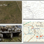
Firstly it maybe as well to look at the original landscape feature from which many others in the locality take their name – Yes Tor, a very small nearby pile of granite which should not be confused with its much larger namesake on the north moor – Yes Tor. The tor was first known as ‘East Tor’ which could have suggested the ‘Easterly Tor’ or have been a dialect corruption of ‘Highest Tor’. This place-name has also in some references mutated to ‘Easter’, the east and tor having joined by once again local dialect. As you can see from the map below the tor has given its name not only to the farm but also a; Bottom, Brook, Ford, and Green.
The English Heritage Pastscape record classifies Yestor farm as a Deserted Medieval Village, Clearly the farm was in existence prior to the building of the railway as its route cuts clean through many of the enclosures, the walls of which in places take an alarming curvy course. Agreed that in some places they contour around the Yestor Brook but others seem not to follow straight lines as one would expect – puzzling? There are some slightly conflicting suggestions as to other documented evidence of the farm’s presence; Brown cites a document of 1673 which refers to a lease for one Anthony Trennamen pertaining to what was called at the time – Yeaster. However, Mike Brown considers that there may be evidence of a much earlier longhouse at the site which could push the dating back but whether this would go as far as the medieval period is another question? Starkey does agree of a much earlier date when he comments that the farmstead was part of the Buckfast Abbey lands and therefore ‘likely’ that the origins date back to the thirteen century. p.99.
Additionally Brown mentions a manor survey of 1791 which records a lease of 1782 was issued to one Stephen Spurr, p. 6. Whereas Hemery suggests that an entry in the Land Tax List of 1785 states that one Samuel Peek was paying tax for the property, p.1032. It could well be that these conflicting dates were due to the fact that the 1785 lessee did not adhere to the terms and the farmstead was never actually built until Stephen Spurr took it over. The fact that the enclosing of the land in the original lease was never done satisfactorily may well account for the irregular and curvy walls?
Over the centuries the farmstead was leased to various folk for agricultural purposes but it seems that in the early 1800s there was a connection with the nearby Swelltor Quarry as in 1825 the lessee was John Johnson the quarry manager. In 1838 an account book records the names of two enclosures; ‘Quarry Park’ and ‘Smith’s Shop Field’, the latter referring to the blacksmiths shop which is located adjacent to the farm. According to the 1851 census returns there were two dwellings at the farm, one lived in by John Ponsford, his wife and two lodgers and the other inhabited by James Perkins, his wife and three children. Brewer, p. 92. But by the mid 1800s the farm lease had reverted back to agricultural labourers thus losing it’s association with the quarry. It is thought that Yestor farm was abandoned sometime in the early 1880s. Hemery, p.1033. I must say that living at Yestor Farm would have had its drawbacks, imagine the continual noise coming from the adjacent quarry and the steam trains thundering by. But there were some plus points such as having a nearby railway halt for trips into Princetown or further afield.
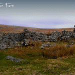
As can be seen from the photos below there is not a lot left of the old farmstead today, just the ruinous walls of the three buildings, enclosure walls and some contentious bee boles. According to the International Bee Research Association’s bee bole register there are two possible bee boles sited at Yestor Farm, their registration number is 1447. They are described as being; “possible bee boles in wall of one of a row of stone pens (not known if they were once roofed); ground level has risen, filling in bottom of recesses, but may originally have been about 30 in. lower; if used for bees, site would have been suitable only in summer.” – on-line source HERE . On the other hand Brown considers that they were simply cupboards as bee boles would not have been situated in a building as the ruins suggest, p.5. The other artefact Starkey mentions are a set of early rick staddle stones used for keeping vermin out of the ricks, unfortunately I was unable to find these but that means nothing. The farm’s water supply would have been delivered by an old tinner’s leat which took water out of the nearby Yes Tor Brook although there is little evidence of this today.
It is just worth noting that although Yestor Farm possible dates back to medieval times it is by far not the earliest settlement in the area, less that 450 metres away are the remains of a prehistoric settlement. This consisted of two co-joined enclosures containing five internal hut circles and four external hut circles, it has also been muted that the ruins were later used as a temporary camp lived in by medieval tinners.

For any Dartmoor 365-ers all of Hayward’s features can be found at the nearby Swell Tor Quarry, he gives no mention of Yestor Farm.

Brewer, K. 1997. The Railways, Quarries and Cottages of Foggintor. Newton Abbot: Orchard Publications.
Brown, M. 1998. Dartmoor Field Guides – Vol. 13. Plymouth: Dartmoor Press.
Hemery, E. 1983. High Dartmoor. London: Robert Hale.
Starkey, F. H. 1984 Odds and Ends from Dartmoor. F. H. Starkey
 Legendary Dartmoor The many aspects past and present of Dartmoor


