 Legendary Dartmoor The many aspects past and present of Dartmoor

“The day was slowly shadowed, and the distance, rolling in sober undulations to the south, already indicated the coming change. Seaward the horizon had faded from blue to a welter of grey, and above Plymouth slant curtains of rain were falling. But the sun shone on Hessary; the clouds broke into silver beneath it and the blue still predominated. Sunshafts fell afar and flung tracts of light through the increasing heaviness, drenching the dim green of the moor with gold, and flashing gentle colour where the first of the ling began to spread its rose.” Phillpotts, p.42.
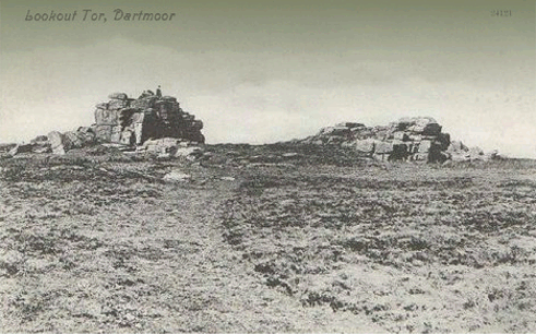
Most people will be acquainted with North Hessary Tor and its lofty TV mast whose ‘red eye’ beams out across much of Dartmoor but what about it’s little brother – South Hessary Tor? In geological terms there is not a lot to say about South Hessary Tor apart from it comprising of two main piles with an avenue between them. Its not huge in comparison with other Dartmoor tors but as Phillpotts describes above there is a far ranging view that reach down to the South Devon coastline – more of this later.
Historically South Hessary Tor has quite an impressive pedigree and has played its part in some important events on Dartmoor. Firstly, in 1240 when King Henry III sent out his “twelve lawful knights’ on The Perambulation of the Forest of Dartmoor Bounds South Hessary or Ysfother as it was documented was one of the boundary points. There are several other names used in the perambulation; Hysfothre, Esforthere, and Heghysfoder. The Place-Name Society suggests that the etymology of the name stems from two elements; hîehst meaning ‘highest’ and foõer meaning ‘load’ which when combined makes no sense at all. So the best that can be gleaned is that the name means the ‘Highest’ something? Other names it has been known as are; Little Histworthie (1608) and Souther Hissary (1702) Gover et. al. p.198. There is one more name that can be thrown into the pot and that is ‘Lookout Tor’, Crossing, 1990. p.103, and once again more of this later.
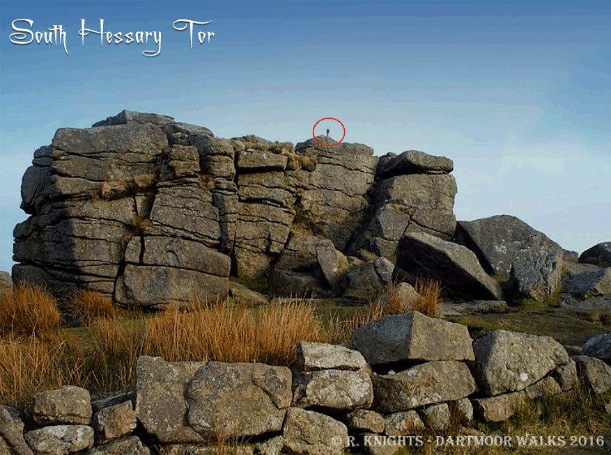
Other boundaries to which South Hessary Tor acted as a marker point were the lands of Buckfast Abbey in 1240, Walkhampton Manor, the Plympton Stannary and the Plymouth Corporation Water Works catchment area. At one time South Hessary Tor was the haunt of a ‘Cobra’ although sadly today it no longer resides there. Sounds a bit fanciful but if you want another alternative then ‘Excalibur’ was once embedded in its granite – yeah right? I kid you not, both ‘The Cobra‘ and ‘Excalibur’ were names given to four small metal ‘spearhead’ shaped spikes that were dotted around the moor. It is thought that these were erected sometime around 1867 and are recorded in a Duchy Deed of Agreement which states; ” … thence similarly to South Hessary Tor (Iron Cross).”, Brewer, p. 156. Each were marked with a ‘W’ on one side and ‘FB’ on the other denoting the bounds of Walkhampton and the Forest of Dartmoor. Unfortunately in 2103 somebody took a dislike to the South Hessary Cobra and broke it off but fortunately it was found and handed into the Dartmoor National Park Authority temporarily stashed away somewhere. At some point in time the Cobra slithered its way back up to the tor where is sits ready to strike today. If you look at Richard Knights’ photograph from 2001 below you can just make out the ‘Cobra’ rearing its head up to the centre right of the tor.
As promised – Lookout Tor, why was South Hessary also called this? As can be gathered from Phillpotts’ description above the views from the tor reach down to the coast so if anybody wanted to keep and eye on any danger coming from this direction the this would be an ideal spot. Hemery explains that: “When Napoleon cast covetous eyes upon England and look-outs on coast and country kept watch to warn the populace of impending invasion, a look-out tower was built, of stone and timber, on the South Hessary – Nun’s Cross ridge, half a mile south-south east of the tor. It was at once named Look-out Castle’ by the moor people, and the tor became known as ‘Look-out Tor’, therein lies the explanation of Castle Road and Castle Farm.”, p. 134. For another theory on the use of the tower was that it was used to keep a watch for any prisoners of war escaping from their captivity, Bound, p.45. This seems a bit odd as it would not provide a good northerly view to spot any escapees heading in that direction?
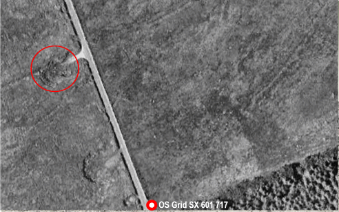
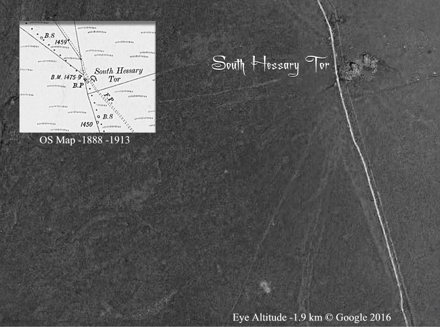
Now I don’t know if this is my imagination but if you look at the aerial photograph below you can clearly see what appears to be a complete circular feature. Hemery states that the look-out tower was half a mile south south-east of the tor, the feature in the aerial photograph is just over a quarter of a mile south south-east of the tor – could this be the shadow of the tower? The only way to clarify this is to actually have a look at it which is what I will do next time I’m down that way.
During Tyrwhitts’ operations at Princetown he built a cottage just east of South Hessary Tor for one of his labourers called Symons, Crossing, 1989. p.17. This must have been a cold place to live as it was directly in the way of the prevailing south-westerly winds and needless to say it is there no longer. For those into ‘Hill Bagging’ South Hessary Tor is number 17497 and is classified as a ‘tump’ which is anything from that sits at an altitude of between 400 and 499 metres. According to the UK Climbing Club the tor is classified as a crag with one climb on it, which I wouldn’t have thought takes that long to accomplish.

As you can imagine with such a history South Hessary Tor has been the subject of various letterbox stamps, a couple of which can be seen above, most of them depict the ‘look-out aspect of the tor


Bound, T. 1991. The A to Z of Dartmoor Tors. Exeter: Obelisk Publications.
Brewer, D. 2002. Dartmoor Boundary Markers. Tiverton: Halsgrove Publishing.
Crossing, W. 1989. Princetown – Its Rise and Progress. Brixham: Quay Publications.
Crossing, W. 1990. Crossing’s Guide to Dartmoor. Newton Abbot: Peninsula Press.
Gover, J. E. B., Mawer, A. & Stenton F. M. 1992. The Place Names of Devon. Nottingham: The English Place-Name Society.
Hemery, E. 1983. High Dartmoor. London: Robert Hale.
Phillpotts, E. 1920. Miser’s Money. London: William Heinemann.