 Legendary Dartmoor The many aspects past and present of Dartmoor

Having recently posted a webpage on the longest stone row on Dartmoor, namely Staldon, it seems logical to say a few words about it’s neighbour. Butterdon stone row is the second longest on Dartmoor and it shows certain similarities to that of Staldon in its design and construction. Another connection is that of the actual place names, Staldon roughly translates to ‘hill of the animal stall/stable which suggests a pastoral activity once took place there. The name ‘Butterdon’ comprises of two elements, once again – dun referring to a hill and butere which literally translates to ‘milk for butter making, Clark Hall, p.61. This, as the late Harold Fox points out, might allude to rich pastures which produced good butter, Fox, p.151. So it is possible that both hills were where pastoral practices at one time took place, how long ago is debatable but considering the large amount of prehistoric settlements in the area one must point the finger at the Bronze Age? There is also one mention that during Saxon times the Butterdon stone row was known as ‘The Old Way of the White Stones‘ which, if true, would suggest an ancient track once followed the course of the row???
The Butterdon stone row can claim to be the earliest documented row on Dartmoor thanks one of the early Abbots of Buckfast Abbey. Sometime during the 1400s the Abbot was involved in a dispute with the ‘men of Devon’ who claimed their rights were being infringed by men of the Abbey. Consequently a map was drawn up which clearly showed a line of stones running northwards past a stone cross on Harford Moor, Butler, p.24. Over the centuries this part of the moor has been involved in various boundary disputes that has led to the addition of at least 5 if not 7 (depending on which terminus to the row is taken) bound stones to the row.
The earliest evidence of man’s ritual activities in this region of the moor dates back to Neolithic times in the form of a long barrow and a long cairn. There then came a proliferation of cairns and other ‘field furniture’ which probably appeared during the Bronze Age making for a truly ritual landscape. Aside from the Butterdon stone row and numerous cairns other ritual features such as menhirs, a kist and two smaller stone rows are present. Throughout its course the stone row in never more than 500 metres from any of these features as it wends it way up to its northern terminal. It has been noted that the stone row was constructed in two phases as suggested by directional changes in its course. It may well be that the builders of the row had not decided exactly where its terminus was going to be when they first started building work, Butler, p.24.
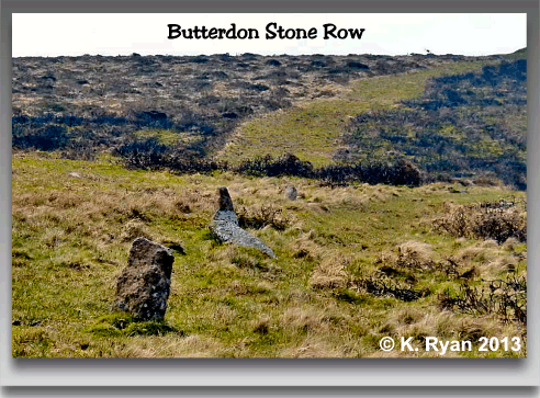
Butterdon stone row begins its course in a northerly direction from a cairn located at a height of 359 metres on Butterdon Hill, (OS grid reference SX 6565 5880). The actual cairn has a diameter of 9 metres and stands roughly 0.3 metres high, in its centre is a hollow. Surrounding the cairn is a stone circle which today consists of 12 recumbent stones of mixed sizes. From this cairn it is possible to see the course of the row running northwards for about 590 metres on an orientation of 2º east of north where it passes slightly west of another cairn. Just north of this second cairn the row takes a different direction as it veers off towards Hobajon’s Cross. All in all the row extends for around 1,050 metres and contains several hundred stones that range in height from 0.1 to 0.4 metres and are spaced at intervals of between 2 to 1.5 metres apart. By far the tallest stones and widest spacing are to be found along the first southern section, Butler, pp. 24 – 25.
As noted above, today the stone row is seen to terminate at Hobajon’s Cross which is a misnomer as it simply consists of a large triangular boulder that has been incised with a Latin cross on its western face. There is evidence of some possible cup marks on its southern face which may well indicate that this stone was in fact the original blocking stone of the row. If this is the case then here is another example of a ‘pagan’ relic that has been Christianised by the addition of the carved cross. John Lloyd Warden Page rather prosaically comes to a similar conclusion when he stated:
“It is at least a pleasant theory which accounts for the presence of the sacred sign on a stone forming part of a heathen alignment. It was carved here, some think, by an early Christian as a protest against the dark mysteries of heathendom, and in the hope of influencing the mind of the barbarous Celt or Saxon, scarcely rescued from the domination of the false creed in favour of the only true religion,” p.254.
There is another theory as to the terminus of the stone row and that was the ‘Longstone’ or menhir which stands 300m to the north of Hobajon’s Cross albeit on a different alignment. Although today the stones have vanished there was continuation of the row shown on what is deemed to be a fairly accurate boundary map of the 1800s which bypasses Hobajon’s Cross??? Eric Hemery also agreed that the Longstone was the intended terminal when stating: “the Butterdon stone row terminates at the fallen menhir called ‘the Longstone’,” p.260.
Throughout its length the stone row passes through several, much later land use features such as an old racecourse, a military rifle range and the old clay works railway and pipeline. It is amazing that so much of the row remains intact in light of the later activity in the area.

Butler, J. 1993. Dartmoor Atlas of Antiquities – Vol. 4. Exeter: Devon Books.
Clark Hall, J. R. 2004. A Concise Anglo-Saxon Dictionary. London: Toronto University Press.
Fox, H. 2012. Dartmoor’s Alluring Upland. Exeter: Exeter University Press.
Hemery, E. 1983. High Dartmoor. London: Robert Hale Ltd.
Page, J. Ll. W. 1895. An Exploration of Dartmoor. London: Seely and Co. Ltd.
One comment
Pingback: Dartmoor from Ivybridge – Panifex Peregrinations