 Legendary Dartmoor The many aspects past and present of Dartmoor

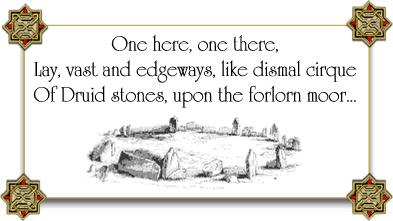
‘Such is the situation of the circles called the grey wethers, below Sittaford Tor, in one of the wildest and most solitary parts of the moor. Each of these consisted originally of twenty-five stones, of which nine remain erect in one, and seven in the other: the rest lie half overgrown with moss and heather. Their height varies from three to five feet, and the diameter of each circle is one hundred and twenty.
In this gloomy district even at midday, the circle of grey stones has a strange power over the imagination; but when twilight is gradually closing, and the only sound that breaks the silence of the hills is that of the stream on whose banks they stand, the circles assume their ancient power. The whole country about them is still the same as in that far distant day when the hand of man erected them for some unknown purpose; and as the wind sighs through the long fern and heather, and the mists rise up from the hill streams, the spirits of the old British priests seem, like the shade of Fingal, to ‘move slowly over the heath, the stars dim twinkling through their forms.’ The solitary wanderer who visits them at such a time, will not wonder that ‘the grey stones of the heath’ should have kept a place in the superstitions of the peasantry long after they who raised them were forgotten; or that mysterious rites should have been done at them…‘, (King, 1856, pp.16 – 17).
Now, doesn’t that make you want to tug on your walking boots and pay a visit on the Grey Wethers? There can be no question that these stone circles ‘have kept a place in the superstitions of the peasantry‘ as there are no less that five legends attached to them. But exchanging myth for fact what we have are two stone circles that belong to the Bronze Age which would age them at around 5,000 years old. According to King’s description above there we 16 stones standing pre-1856, ‘nine remain erect in one, and seven in the other‘. A plan of the circles was drawn by W. C. Lukis in 1879 but by 1870 Spence Bate reported that several of the stones were missing, it was assumed that they had been taken to repair the nearby Whitehorse Leat, (English Heritage, 2009, online-source). Whilst on this point, it is amazing that any of the stones have survived at all when one considers the amount of newtake wall building that took place in their vicinity. Numerous other prehistoric monuments on Dartmoor have been badly despoiled for such purposes. In 1891 Robert Burnard published a detailed plan of the circles and measured each of the remaining stones whether they were standing or fallen, (Burnard, 1986, Vol. II pp. 51 – 54). Interestingly enough his tally of standing stones exactly matched that of King’s previous count, this then either means Lukis’ plan was wrong or Spence Bate mis-counted?
In 1909, Burnard decided to ‘restore’ both circles which today creates a problem as nobody knows how accurately this work was carried out although English Heritage Field Investigators consider that some of the stones are misaligned. It is apparent today which stones were re-erected in the ‘restoration’ process as many of them have small packing stones around their bases. Just maybe it could be suggested that modern(ish) man has never completely mastered the art of stone circle construction, the original builders never needed to use packing stones?
However, today we are presented with the two circles, the northern one has a diameter of 31.5m and consists of 20 standing granite slabs which average about 1m high. Its counterpart, the southern circle, has a diameter of 33m with 29 stones standing, these vary in height from 1 – 1.4m, (English Heritage, 2009, online-source). Many of the granite slabs have a regular, rectangular form which has lead several writers to suggest that they had been worked by human hand, (Petit, 1974, p.142). On the other hand, several writers have refuted this claim and note that similar granite slabs can be found naturally occurring on nearby Sittaford Tor, (Worth, 1988, p.260).
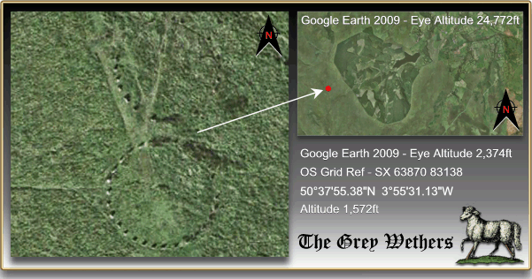
In a Dartmoor context The Grey Wethers can be considered the third largest circles (thanks to a 2015 discovery of a larger nearby circle) to be found on the moor when diameters are considered. They are certainly located at the highest altitude of all the known Dartmoor stone circles and are the only example of double circles. A quick look at the Ordnance Survey map will soon show that these stone circles stand in a busy prehistoric landscape containing many features. Near to the Grey Wethers is evidence of an oval enclosure measuring 40 x 48m which is surrounded by a 0.6m stony bank. Although the bank has been damaged where stones have been robbed there are what is thought to be two original entrances. This has lead to the suggestion that that the feature is in fact a henge. A smaller example can be seen nearby although it is half the dimensions of the first one and is in better condition. The Dartmoor Excavation Committee dug some test pits in 1902 in the latter enclosure and found nothing but a long narrow stone lying near its centre. Butler postulates that as there are no present day stones of such a size to be found in the area this stone was purposefully ‘dragged’ to the site. Several cairns are also located nearby, one of which was excavated in 1898 by the Dartmoor Excavation Committee. Although previously undisturbed they only found a 0.8m deep pit containing only charcoal, (Butler, 1991, pp165-6).
It can be assumed that The Grey Wethers are unique in many ways but the big question is what was their purpose? Today you can see shallow pits in the peat inside the circles, these are the result of trial excavations carried out by the Dartmoor Exploration Committee in 1898. These excavations revealed a layer of charcoal covering the natural surface, (Butler 1991, p.165). Gerrard suggests that this evidence could indicate the use of fire in whatever rituals were being carried out at the site. Similar finding come from the nearby Fernworthy circle, (1997, p.61). As can be seen from the location map the circles are located on a prominent ‘shelf’ between two major water sources; the North and South Teign rivers, was there any significance for this? Burl, (2000, p.153) considers that the circles were deliberately placed in order to act as a pass between the two river heads. Could it be that the circles divided two tribal lands and was the ‘neutral’ meeting place for rituals, feasts or trade exchange? Perhaps the two circles signify some event that united two tribes, each monument relating to one of the tribes? In this north eastern sector of Dartmoor there is a cluster of 8 stone circles whose locations for a ‘sacred crescent‘ when plotted on the map and Scorhill sits in the middle of these.

Burl, A. 2000. The Stone Circles of Britain, Ireland and Brittany, London: Yale University Press.
Burnard, R. 1986. Dartmoor Pictorial Records, Exeter: Devon Books.
Butler, J. 1991. Dartmoor Atlas of Antiquities – Vol. II, Exeter: Devon Books.
English Heritage. 2009. Pastscape Record – Grey Wethers Stone Circles, on-line source – see link opposite.
Gerrard, S. 1997, Dartmoor, Batsford, London.
King, R. J. 1856. The Forest of Dartmoor and Its Borders, London: John Russell Smith.
Page, J. Ll. W. 1895. An Exploration of Dartmoor, London: Seeley & Co. Ltd.
Pettit, P. 1974, Prehistoric Dartmoor, David & Charles, Newton Abbot.
Worth, R. H. 1988. Worth’s Dartmoor, Newton Abbot: David & Charles.