 Legendary Dartmoor The many aspects past and present of Dartmoor

Corndon Down was a very special place for the folk who roamed Dartmoor in the Bronze Age, so much so it could have been regarded as a ritual place where they buried their dead. Why? Probably because of the wide ranging vistas that can be seen from the top of the down thus giving a high visibility within the landscape. It certainly seemed rather ‘spiritual’ the day we visited as the whole of the down was shrouded in mist which came rolling in opaque waves with the occasional interruption of golden rays of sun bursting forth. Not the ideal conditions for photography if the intention was to portray the place but perfect for adding an air of mystery.
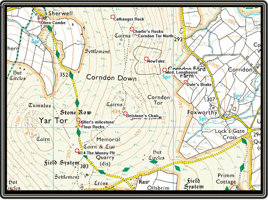
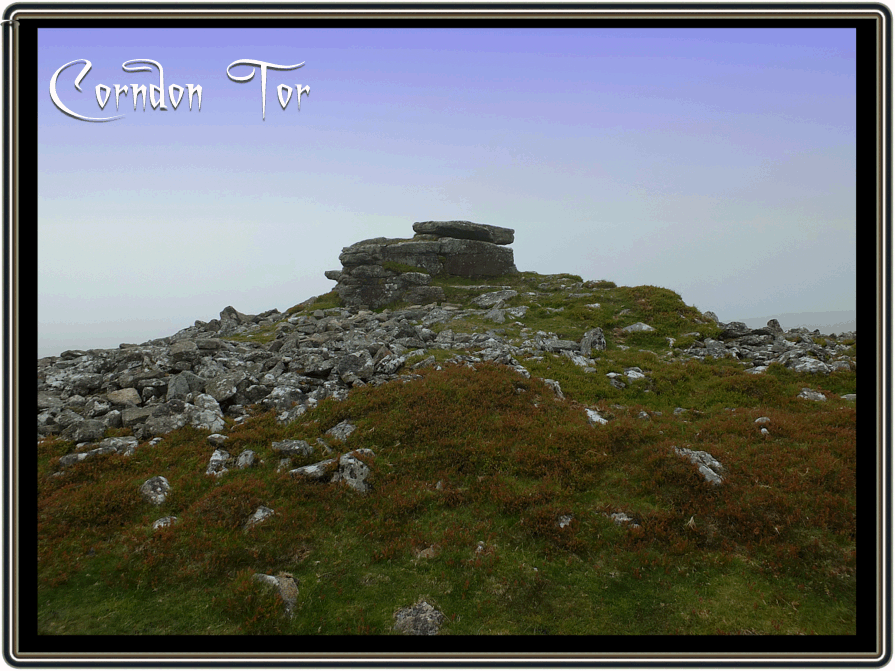
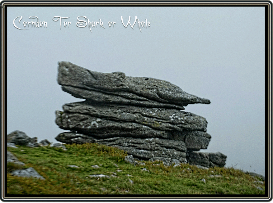
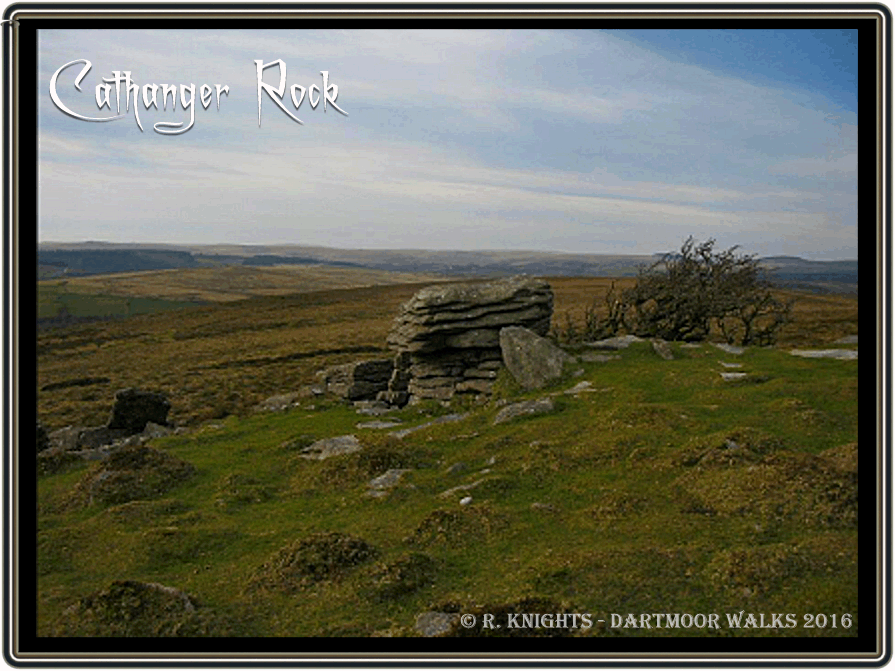
For anyone who has a penchant for place-names Corndon Down is somewhere that will satiate their appetite as dotted all over the area are several names that no longer appear on any modern map. On many old maps Corndon Down appears as Corn Down which possibly has mutated from Cairn Down in reference to the various cairns dotted around the area. However the modern name could lead to confusion as the ‘don’ element refers to a down which is duplicated in the second name ‘down’ and therefore superfluous. The highest point of Corndon Down is not surprisingly Corndon Tor which sits comfortably at a respectable spot height of 434 metres. Over the centuries the tor has be known by various names; Curnen Tor, Quarnian Tor and Quarnell Tor, Ringwood, p.55. At the southern end of the main tor is another small outcrop which according to Mike Brown has gained the name of ‘Belstone’s Chair‘, p.9. whether this was associated with a surname or the actual village nobody knows. Whilst on the subject of ‘Belstone’ the actual rock on which the Cave-Penney Memorial Cross sits has/is known as the ‘Belstone Bible‘, Hemery, p.528, again there is no explanation. There is also another much smaller tor some 600 metres to the north of Corndon Tor known simply as Corndon North Tor. Another rock pile on the down has the curious name of ‘Cathanger Rock‘ which is located some 750 metres north of the main tor. According to Hemery the name comes from the fact that at one time the over hanging canopy of the tor made for a shelter in which the wild cat made its sett. The clitter on the western slope of Cathanger Rock was once referred to as ‘Charlie’s Rocks‘, 1986, p.251. Just north of Cathanger Rock is a small guide stone called ‘The Little Boy‘ which served as a guide stone on the Sherwell to Widecombe Church Path. To the west of this stone is the small hamlet of Sherwell where buildings such as the ‘Rogue’s Roost‘, ‘Little Roost‘ ‘Cockler’s Peep Inn‘ and the ‘Hornet’s Castle‘ were/are to be found, again all names to conjure with. One rock which in recent times seems to have gained some fame is the ‘Shark’s Head Stone‘ which can be seen on Corndon Tor. If one uses their imagination the pointed end of this outcrop does somewhat resemble the head of a shark as can be seen below. Although it is possible to see a whale’s head at the opposite end from certain angles. Another group of rocks are situated somewhere on the lower west side of the main tor somewhere beside the road known as the ‘Miller’s Mile‘. Firstly, the reason the road is so known is that it runs down to an old corn mill at Babeny which was exactly one mile away from the Miller’s Mile Stone. The reason the rocks are called ‘Flour Rocks‘ is that; “they mark the spot where once a pack-horse returning southwards with two sacks of flour lost half of his load, with the result that the rocks received the cascade of flour and retained a pale hue for some weeks to come.”, Hemery, p.529.
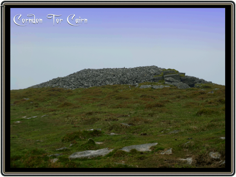
As one ascends the west side of Corndon Down the Cave-Penney Memorial Cross is the first thing that easily comes into view. From there the rest of the journey takes you back into prehistoric times. The whole of the down is criss-crossed with ancient field boundaries or reaves which belong to the ‘Dartmeet Parallel System’, those around Corndon Down being central to the system. In Fleming’s opinion the best vantage point to view the system is from Corndon Tor and gives the most dramatic central zone perspective, p.76. Many of these reaves can easily be spotted on Google Earth especially when you view the 2002 historical imagery from an eye altitude of 3.38 kilometres. On reaching the highest point of Corndon Down you will be greeted by the main outcrop of Corndon Tor. The first impression may well be that somebody had attacked the tor with a huge jack-hammer as all around it are scattered piles of smaller granite blocks cascading down from the summit. This is in fact the remnants of a prehistoric cairn, originally the stone would have been piled much higher although probably not completely covering the tor. When seeing sights such as this it does make one wonder the effort that must have gone into heaving those heavy granite rocks into position? Just north of the main outcrop of Corndon Tor is a much larger and more impressive cairn which has a diameter of roughly 27.5 metres and rises to a height of about 2 metres. As with many of the cairns this one had been subjected to the attention of ‘tomb raiders‘ in search of ‘valuable’ treasure. As one looks in a northerly direction across from Corndon Tor there are two ‘pimple-like’ piles protruding from the nearby ridge-line, these are two more cairns. Both have a diameter of about 28.5 metres with the eastern cairn rising to a height of roughly 2 metres and the western one slightly lower. Butler states that back in the 1820s a hoard of about 50 holiday makers along with some local folk decided to do a spot of DIY archaeology and rifle through the cairns. Much to their disappointment these ‘tomb raiders‘ found what they regarded, as worthless jars but today would have probably be described as valuable grave goods. p.131. Harry Starkey in a moment of curiosity once attempted to work out the tonnage of granite blocks which made up the larger of these two cairns – his estimation was between 2,000 and 3,000 tons, p.103. Now working on his theory, 1 ton = 2,240 lbs and an average man should be able to lift around 50 lbs (22.67 kg). Taking the lower estimation of 2,000 tons of granite that equates to 89,600 single blocks to lift, then suppose that one man could lift 100 of these a day it would take 896 days or 2.45 years to build and this excludes getting the stone to the site, then assume that there were ten men doing the building it would still take 89.6 days of solid work to construct. And so on and so forth but no matter the number of people working on the cairn it still was a major accomplishment. It’s also worth remembering that at the time of construction the people would have had farms to work and livestock to tend along with the other daily chores of prehistoric life. So these cairns would have had to be built in their spare moments, just imagine the wife saying to her husband of an evening; “and where do you think you’re going?” and he replying; “oh just popping down the cairn to put some more rocks on it, sweetness.” To which she retorts; “well don’t be late back, it’s a busy day tomorrow.”
Just below Corndon Tor are the remains of a mystery circular construction which initially appears as a hut circle but on closer examination does not conform to the usual appearance. It seems to possibly be of a later date, perhaps a shelter of some kind as can be seen below.
Some 500 metres north(ish) of Corndon Tor can be seen the walls of an odd-shaped enclosure which looks something like a loaf of bread, this is known simply as ‘Newtake’ which belonged to a nearby deserted medieval longhouse. The remains of which consist of turf covered granite walls to the height of just under 1 metre which enclose a space of 9.8 by 4.2 metres. Some 600 metres north(ish) of this medieval longhouse was another located in the enclosure known as Dinah Clarke’s. This site was excavated in 1966 when an assemblage of pottery was discovered which dated back to between the late 13th and early 15th centuries.


The old Sherwell branch of the Widecombe Church Path makes its way across the northern end of Corndon Down to its exit point at the head of Pepper Lane. It’s along this that folk would travel on their way to St. Pancras’ Church and with any ancient church path tales of the supernatural will follow. On some dark nights it is possible to hear a faint murmur of people’s voices slowly wafting across the down but there is never anyone to be seen, is this the ghostly vestiges of the old parishioners making their way to church? According to tradition the hamlet of Sherwell was once a den of iniquity. The Cockler’s Peep Inn was renown for a place where cock fighting took place and the Rogue’s Roost had a reputation for being the haunt of some notorious sheep rustlers hence its name. At one time there was a white witch called Granny West who also lived at the Rogue’s Roost. Unfortunately her teenage son had metal health issues and so she kept him locked up in an outhouse out of harms way. One day a passing a huntsman happened by and saw much to his alarm the boy staring out of a window. Thinking this a bit odd he reported the matter to the local authorities who after an investigation removed the lad to an asylum where he died shortly afterwards.
 Brown, M. 1999. Dartmoor Field Guides – Vol. 25. Plymouth: Dartmoor Press.
Butler, J. 1991. Dartmoor Atlas of Antiquities – Vol. 1. Exeter: Devon Books.
Fleming, A. 2008. The Dartmoor Reaves. Oxford: Oxbow Books.
Hemery, E. 1983. High Dartmoor. London: Robert Hale Ltd.
Hemery, E. 1986.Walking Dartmoor’s Ancient Tracks. London: Robert Hale Ltd.
Ringwood, K. 2013. Dartmoor’s Tors and Rocks. Plymouth: Plymouth University Press.
Starkey, F. H. 1984. Odds and Ends from Dartmoor. F.H. Starkey.
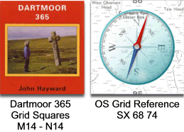
The two 365 targets for these grid squares do not include anything on Corndon Down, M14 suggests the two farms at Shallowford and N14 goes for the ‘Money Pit‘ below Yar Tor.