 Legendary Dartmoor The many aspects past and present of Dartmoor


“Beyond, like the hogged back of a brown bear, Wigford Down rolled over the gorges of Dewerstone, and further yet, retreated fields and forests, great uplifted plains, and sudden elevations that glimmered along their crests with the tender green of distant larch and beech.” Eden Phillpotts – The Three Brothers, p.2.
Wigford Down is a tract of moorland which belongs to the common of Yennadon Down, Lynch Common and Dewerstone, it’s registration number is CL191 and covers 408.91 hectares in the parish of Meavy. The down covers roughly two square kilometres and its highest point is 273 metres. The whole area is an excellent example of a Dartmoor palimpsest which shows evidence of man’s presence and land use from the Bronze Age through to the medieval and post medieval periods.
The origin of the place-name Wigford is rather sketchy to say the least, Gover et. al from the English Place-Name Society suggest it derives from a personal name – Andrew de Wigheworthi They then go on to suggest that he may have originally come from Wigford hence his surname, p.231. This place-name in turn derives from two elements, one a personal name – Wicga and the other a descriptive – worõig meaning an enclosed homestead or farm (later known as a Worthy) thus giving ‘Wicga’s homestead/farm enclosure’, p.306. . At some point in time this man named Andrew came into possession of the worthy who then moved to Fernhill which was near to Wigford Down. In doing so took his surname along with him and tagged it to the down thus giving ‘Wigheworthi Down’. It is interesting to note that there are three nearby obvious one-time ‘worthys’; Cadworthy which is on the south side of the down and Brisworthy and Trowlesworthy to the east. If this theory is correct it does show how misleading place-names can be as initially one would have thought that somehow a ‘ford’ or ‘ water crossing’ would have been involved? However if you look at the location map of the down there is very little water to cross.
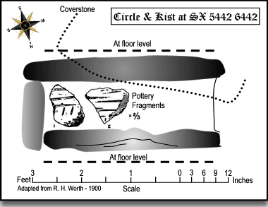
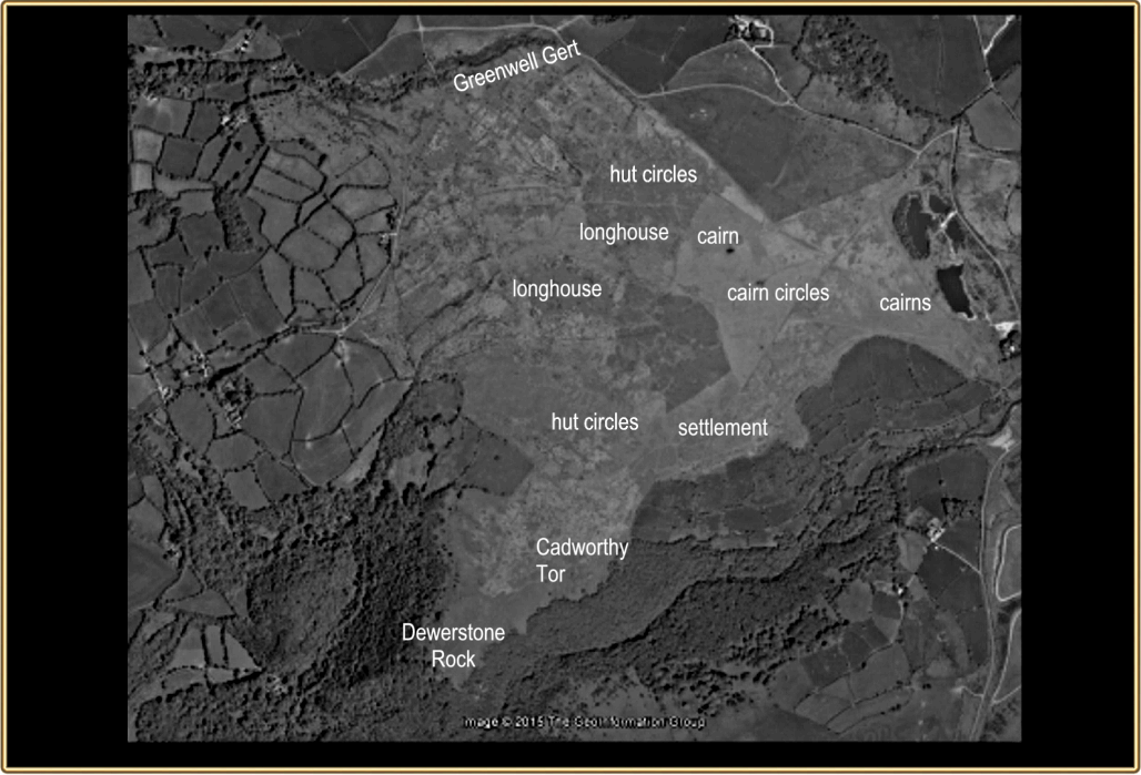
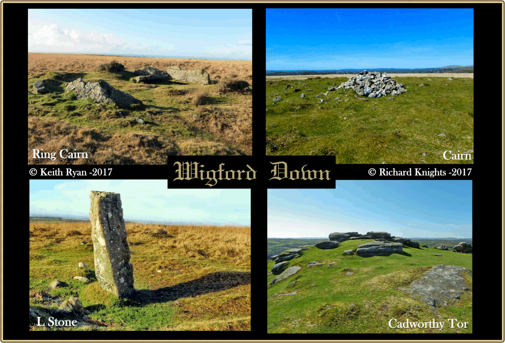
So, let’s wind back time to the prehistoric times, the first evidence comes from the Bronze Age period in the form of a small enclosure with four associated hut circles, it has been suggested that possibly this settlement was larger with some of the other hut circles being lost in the Lower Cadworthy fields, Butler, p.78. Some 350 metres south-west from the enclosure lies a cairn, cist and it’s retaining stone circle located just above Lower Cadworthy Farm (SX 5442 6442). This was excavated in the early 1900s and two pottery fragments were recovered which it has been suggested belonged to a funereal urn. These fragments were similar to some more recovered from a hut circle at Legis Tor which lies some three kilometres to the north east and dates to the Late Bronze Age. This does suggest there was some kind of interaction between the folk living on Wigford Down and Legis Tor.
From the cairn if we go some 700 metres in a south-south-westerly direction the timescale possibly goes back even earlier to the Neolithic period. Here at grid reference SX 5395 6408 is located the Dewerstone promontory fort. Today this consists of two collapsed stone walls forming an outer enclosure inside which sits an inner enclosure and hut circle. Early thoughts on its age suggested that the fort belonged to the Iron Age period as its position was similar to other examples found on Dartmoor. In 1948 Worth decided that maybe the date should be moved back to the early Bronze Age. As if to confirm this fact in 1960 a pottery beaker dating to the middle Bronze Age was found just north-east of the enclosure. In 1974 Paul Pettit considered that maybe the enclosure dated to the Bronze Age whilst the two walls were later Iron Age additions. Some five years later R. J. Sylvester came up with the notion that these features didn’t fit any existing classification and so named them ‘tor enclosures’, (another possible example of one these on Dartmoor being Whit Tor). In 1994 the RCHME carried out an analytical earthwork survey on the summit of Dewerstone and considered that the outer enclosure was potentially Neolithic in date and the inner enclosure Bronze Age. To this day there is still no firm consensus as to the date of this feature.
The next group of prehistoric remains lie about 660 odd metres north-north-east of the Dewerstone tor enclosure. Here is a small cluster of four hut circles which range from 21 – 25 metres in diameter along with four associated fields. Roughly 680 metres north-east of these hut circles lies two raised platform cairns with their retaining stone circles, the smaller of the two still shows a central kist cover. Some 140 metres north(ish) of these cairns is another although now it has been virtually destroyed. Incidentally this was once the site of an Observation Post which may have had some bearing on the state of the earlier cairn, Butler, p.80. Some 500 metres north-west of this cairn is a visible retaining circle however in this instance all of the cairn stones have been removed. Some 170 metres south(ish) of the above circle is another small settlement comprising of four huts in two groups. Along with the above domestic and ritual features are a whole network of reaves, field systems and trackways some of which are still visible from the ground and on aerial photographs.
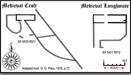
Now we can leap forward in time to the medieval period where the remnants of two early dwellings can be seen. The first is located on the mid-western slopes of the down (SX 5411 6513) near to Blacklands Mire. It has been suggested that this structure consisted of a dwelling place and adjoined byre or in other words a longhouse. Along with the building are signs of early arable usage in the form of ridge and furrows and a line of clearance cairns along with field boundaries and a holloway. The second medieval structure lies intermingled with parts of the Bronze Age enclosure (SX 5433 6521) and has been described as a croft. Here there seems to be a suggestion that some of the field boundaries have absorbed the prehistoric ones.
The other early monument on Wigford Down is the ancient wayside cross located at grid reference SX 5332 6473 known simply as Cadover Cross. What you see today is the result of several restorations with only the head and a short part of the shaft being original. It is thought that the original parts of the cross date back to the 1200s and served as a marker along the monastic track which ran between Plympton Priory and Tavistock.
Industrial activity is represented by areas of tin streaming/openworking along the shallow valley bottom; this is known to have been worked in the 16th century; associated with this are a number of leats and reservoirs. Several disused 19th century china clay pits, remains of the Wigford Down China Clay Works, are present along the eastern edge of the Down, north of Cadover Bridge.
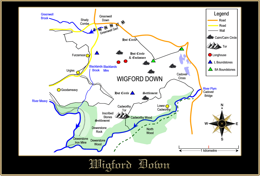
As can be seen on the map above there are several boundstones dotted around the down, none of which are marked on the OS maps. The first boundstone belongs to a series of six nineteenth century stones that mark the limits of the Maristow Estate. All are inscribed with the letter ‘L’ which stands for Lopes who was the owner of the estate, the one which actually sits on Wigford Down can be found at OS grid reference SX 5380 6525. The other cluster of boundstones are located at the western edge of the down the first one sits at the end of a wall at OS grid SX 5472 6522. This is a set stone which stands about a metre high with the letters ‘BA’ inscribed on one side and the letter ‘A’ with a line under it and possibly may date the late 1700s. Three more ‘BA’ stones can be found at grid references; SX 5475 6515 (recumbent), SX 5515 6530 (a large boulder) and SX 5520 6535. At one point in time it was thought that these last three ‘BA’ stones marked the lands of Buckland Abbey but later it was considered that they marked the lands of Buckland Estate. Brewer, pp 236 -237.
In 1873 much of the area around Wigford Down was used for military manoeuvres which lasted from the 28th of July to the 21st of August. Towards the end of the exercise much of the operation were carried out entirely on the down. As with any military training exercises there are the occasional casualties and on this instance there was a report of a rider and horse of the Royal Horse Artillery coming to grief. The horse was a ‘wheeler horse’ pulling a field gun down the steep hill leading from Wigford down when the ‘drag shoe’ flew off thus throwing the horse and rider. Sadly the horse was then dragged along for a fair distance and had to be destroyed. Over the following years Wigford Down was the location for many more such exercises right up to the 1950s.
It has been said that on stormy nights the Dark Huntsman can be seen riding out over the down with his fierce pack of hell-hounds who are always in hot pursuit of a spectral fox. The frantic chase runs all over the down and across the Cadover where huntsman, hounds and fox simply dissolve into oblivion. Whilst on the subject of hunting Wigford Down was once a popular venue for hare hunting. A report from 1922 tells of one such occasion when the Sperling Harriers were outwitted by one canny hare; “Our first hare came from a hollow on Ringmoor and proved to be a real stout-hearted customer. From Ringmoor jack ran past the cot, down into the valley by Yeo Farm, and then left-handed up Lynch Hill, pointing for Brisworthy. Scent was not of the best, but by persevering the hounds carried on to the bank and then right-handed into Brisworthy Plantation. Running round the plantation the hounds broke on the road side and then through the fields to Wigford Down. Here the scent was wonderfully better, and at a great pace they ran up over Wigford Down, pointing for the Dewerstone, for al as if they had changed into a ‘long-tail’. At the far end of Wigford Down, near the enclosures, our hare was evidently feeling the effect of the bustling, for he began to twist and double on the marshy ground, finally setting off on what looked like a return trip to Ringmoor. Near the crossroads I think he was headed off by a motorcyclist for he was seen to double, and then ran back across Wigford Down to Urgles, just above Good-a-Meavy. Here in the enclosures scent failed altogether, and this stout jack escaped after leading the hounds a rare dance of just 60 minutes.” The Western Morning News, March 14th, 1922.

Brewer, D. 2002. Dartmoor Boundary Markers. Tiverton: Halsgrove Publishing.
Butler, J. 1994. Dartmoor Atlas of Antiquities – Vol. 3. Exeter: Devon Books.
Gover, J. E. B., Mawer, A. & Stenton, F. M. 1992 The Place Names of Devon. Nottingham: English Place-Name Society.
Phillpotts, E. 1909. The Three Brothers. London: Hutchinson & Co.
Price, D. G. 1978. Settlement & Ancient Fields of Wigford Down. Transactions of the Devonshire Association – Vol. 110.