 Legendary Dartmoor The many aspects past and present of Dartmoor


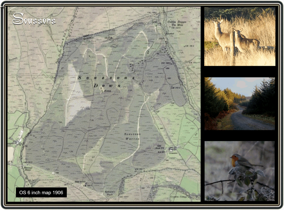
There is an early placename of Soueston, in 1771 the Recovery Rolls documented the place as North Souson, in 1809 Mudge’s map of Devon shows it as South Stone Farm and today it’s known as Soussons. The English Place-Name Society suggests that the name could originally have meant “at the seven stones’, Gover et. al. p.482. This possibly could refer to the Ringastan or the Soussons Stone Circle which is situated at the south end of the plantation. William Crossing offers several more suggestions as to the etymology names around the area; South Sands, South Stone Common, South Shute Common, 1990, p. 472 fn.
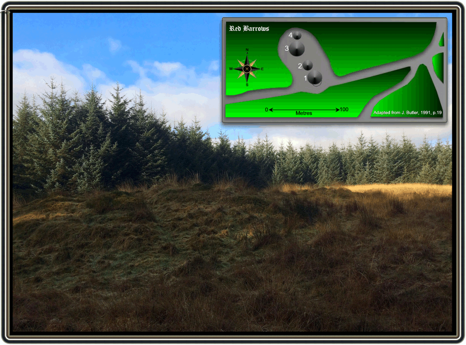
As can be seen from the map below the whole area around Soussons Down has been inhabited since prehistoric times with special ritual use as testified by the remnants of cairns, ring cairns and a kist. That is what remains today, heavens knows what has been lost during the afforestation of the area. Probably the most significant ritual monuments to remain on Soussons are the Red Barrows which luckily has been spared by the foresters. Red Barrows consist of four Bronze Age round barrows all of which are now scheduled monuments. In 1902 the Dartmoor Exploration Committee of the Devonshire Association ‘explored’ the three barrows and published their findings in 1903. TDA PP..143 -145. At the time it was reported that all of the barrows were pitted with rabbit holes and the actual cairns had been robbed of their stones. If you look at the early OS map below you will see that nearby was a wall, no doubt the destination for the stones. The southernmost barrow (number 1 on the diagram below) had a diameter of 18.2 metres and was found to contain a pit, some 1.8 metres below the surface. Inside the pit the excavators found some charcoal and a small flint flake. Near to the northern circumference of the barrow was a small, circular kistvaen in which was discovered some burn bone which included a fragment of human skull and another flint flake. At the south end of the barrow they found a small sherd of pottery which at the time was dated to the Bronze Age. It also appeared that at some point in time the southern end had been reinforced by a revetment of large stones. During the excavation ‘many hundreds of cartloads’ of earth were removed and short of removing the entire barrow it was decided to move onto the next barrow in the line. Butler also points out that although not mentioned in the report there is a slight bank and a possible ditch running to the base of the barrow on the uphill side which may have once been a reave. 1991, p.18. It is hard to imagine today what the reason for positioning these barrows there but you can still get a glimpse of what features once would have been visible. There virtually would have been a 360° panorama of the far flung moors and tors.
The next barrow (number 1 on the diagram below) was found to be slightly smaller than its neighbour with a diameter of 13.7 metres, it was estimated that the excavators had trenched about half of the barrow. There were signs that this barrow had been previously visited by some tomb raiders but luckily they had not discovered the central pit. Once again the pit was found to contain some tiny fragments of burnt bone along with quantities of wood charcoal. Next to this pit and just under a metre below the central surface of the barrow but level with the edge of the pit was a small area of paved stones. Both inbetween and under neath the paving more fragments of burnt bone and charcoal were discovered. Just under a metre above the paving two fragments of bronze was found however thanks to the activities of rabbits the archaeological context could not be confirmed. Roughly 2.7 metres in and 1 metre down on the western edge of the barrow was found a flint arrow head.
The two remaining barrows (numbers 3 and 4 on the diagram below) were at the time described as being; “barren of any result; they were mere heaps of stone only a few inches above ground level,” they had circumferences of 18.2 metres (number 3) and 7.9 metres (number 4). It was also noted in the report that another ruined cairn lay some 270 metres which had a circumference of 9.4 metres and sat at the head of a ruined triple stone row. Butler mentions this triple stone row and notes that this would have been just one of three known to exist on Dartmoor. 1997, p. 38. He also states that many of the stone row had been partly damaged by 1897 when the stones were taken to facilitate the building of nearby enclosure walls, 1991, p.19.
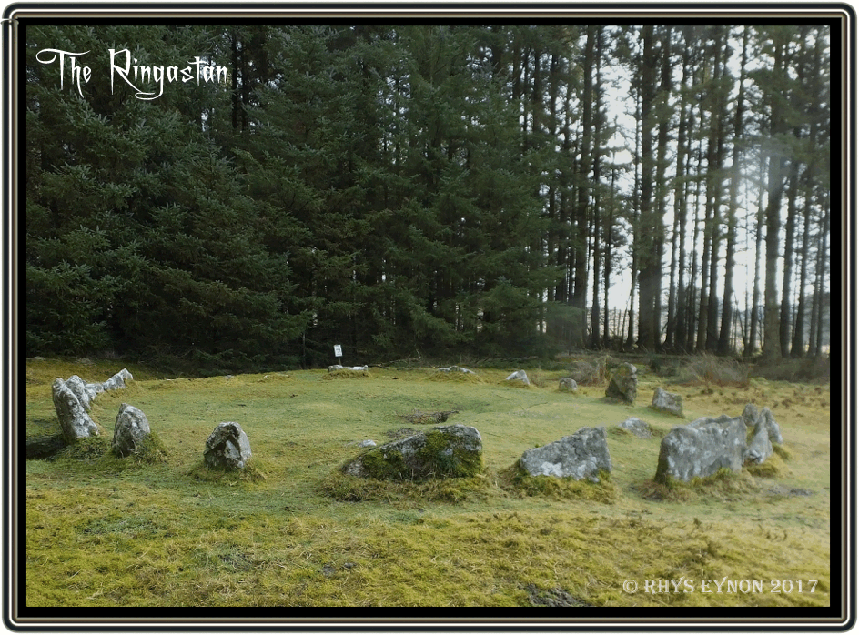
Probably of all the prehistoric ritual monuments around Soussons is the Ringastan or Soussons Stone Circle which is situated just outside the southern edge of the plantation. This is a cairn circle dating to the Bronze Age. Butler, 1991, p.19. describes the circle as consisting of 22 visible stones with a diameter of 8.6m., at the centre of which are the remains of a kist. When the Dartmoor Exploration Committee excavated the kist in 1903 they discovered that there was a false paved floor under which was hidden two large coils of human hair. It was thought at the time that they were evidence for some recent activities that involved witchcraft of some kind. The kist has often had fires lit in its cavity, so much so that the D.N.P.A. filled it in 1994. This was to prevent the heat from the fire splitting the side slabs of the kist. But, as always this has not stopped the problem and often you can see remnants of fires and various votive offering left at the circle.
If one time travels onto the medieval period there are remnants of that period dotted around the plantation certainly in the form of enclosure walls and a deserted medieval farmstead. English Heritage suggests that this was probably the Ancient Tenement of Warner which if it is was first documented in 1301 as Walna. The tenement covered approximately 20 hectares, and comprised of a multitude of earth and stone banks, which are between 1.6 and 2.5 metres wide and up to 1.7 metre high. Only two enclosures of 1.0 and 0.8 hectares and an embanked trackway which was probably a droveway remain relatively intact. The better preserved enclosures at the south-western end of the area posses 1.2 hectares of ridge and furrow. The ridges measure 2.8 metre wide and are a maximum 0.2 metre high. Agricultural activities seem to have been abandoned in this area during the search for tin. Many of the field boundaries in the northern part of holding were destroyed and others adapted as water channels for the industry – English Heritage Pastscape Record.
Later landuse prior to the plantation appearing was that of a rabbit warren, namely Soussons Warren. Very little has been written about this warren, Crossing briefly mentions that the warren was at one time owned by a Mr. Eives and was occupied by Messrs. Leaman and Widecombe. 1996, p.61. It is a known fact that the warren was operating in 1863 because a newspaper report of the time noted how: “Thomas Hamlin of Widdecombe-in-the-Moor, and Samuel Hamlin of Lydford, labourers, were charged with trespassing in the pursuit of game, on Soussons Warren, the property of John Westington of Manaton.” They were both fined 10 shillings and 11s 9d costs or if not paid then they could look forward three week in prison. Samuel Hamlin was further charged with setting wire snares for the purpose of catching game at the warren. This earned him a further fine of £1 or one month’s imprisonment. The following year a certain Edward Caunter of Widdecombe-in-the-Moor was hauled before the petty sessions charged with stealing a rabbit from Soussons Warren, the property of John Westington who lived at Manaton. Having the notion that some of his rabbits were being poached he posted his son as nightwatchman. At about 3.00 am. he observed Caunter’s dog kill a rabbit which was then rapidly retrieved by Caunter and taken away. The clerk of the court noted how under the 122nd clause of the night poaching act the case had to be sent to trial as the magistrates on the bench had no power to deal with the offence. Another clause was then found which stated that they did have the power to pass judgement and could sentence Caunter to three months in gaol. In the end after much deliberation it was decided that Caunter could settle the matter out of court.
Initially it seems there was virtually no public consultation regarding the afforestation of Soussons Common. At the time the main concerns were the loss of the common and the associated commoners rights and the fear that there was no way the trees would ever grow on it. In the January of 1947 the following report appeared in the local press; “Regarding the public anxiety concerning the recent arrival of bulldozers and ploughing operations on Soussons Common, between Widecombe and Postbridge this is for forestry. I saw the manager, who stated that an extensive bit of Moor between the end of the Vitifer Mine Valley and Cator has been fenced off for fir tree planting which will take three years to complete.” It appears that the Forestry Commission were none too informative about their plans for Soussons, the following month Lady Sylvia Sayer wrote the following; “Soussons Common had been enclosed and ploughed preparatory to planting trees. There was every indication that this was done without reference to anyone. I am not against the growing of timber, but at the moment, planting is going on unchecked on the common, and I understand that Challacombe is soon to be enclosed. There is nobody to stand up for the ordinary rights of people.” On the other hand another Dartmoor notary, Beatrice Chase was of a different mind; “One statement talked of the ‘encroachment’ by the Forestry at Soussons. This is very stale and ancient history; I was out there talking things over with the manager a year ago,and as the public will not be excluded there is no encroachment. A very fine hut circle in the centre of the area to be planted has not had a stone disturbed and the Forestry has the right to plant trees for the good of the nation on its own land, ceded to it by the Duchy.” In reply Lady Sayer commented that; “Once a part of the Moor has been enclosed, trenched and close planted, hill grazing and fee access have gone from that area for ever – even though the conifers (as often on Dartmoor) may never grow to be more than stunted weaklings. Access to the plantations is allowed but it is access merely to the straight paths that bisect them. That is not free access. Off those paths the ground is furrowed so deeply that there can be no walking – only a climbing from one trench to the next (as an attempt to traverse what was once Soussons Common will show)… All we can now hope for is that when Dartmoor becomes a national park there will be those in charge of its destiny with the will and the power to prevent all further encroachments upon it by Government Departments and other despoilers – not only for the time being, but for ever.” January 1949.
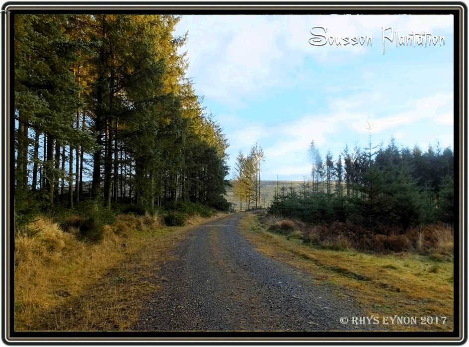
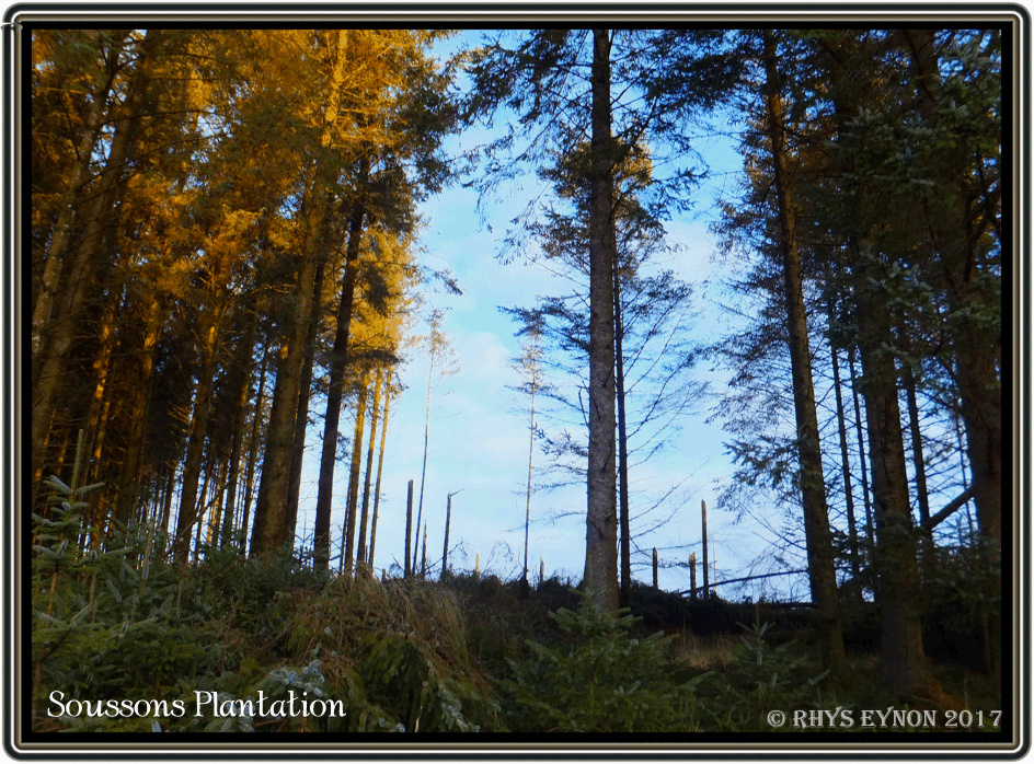
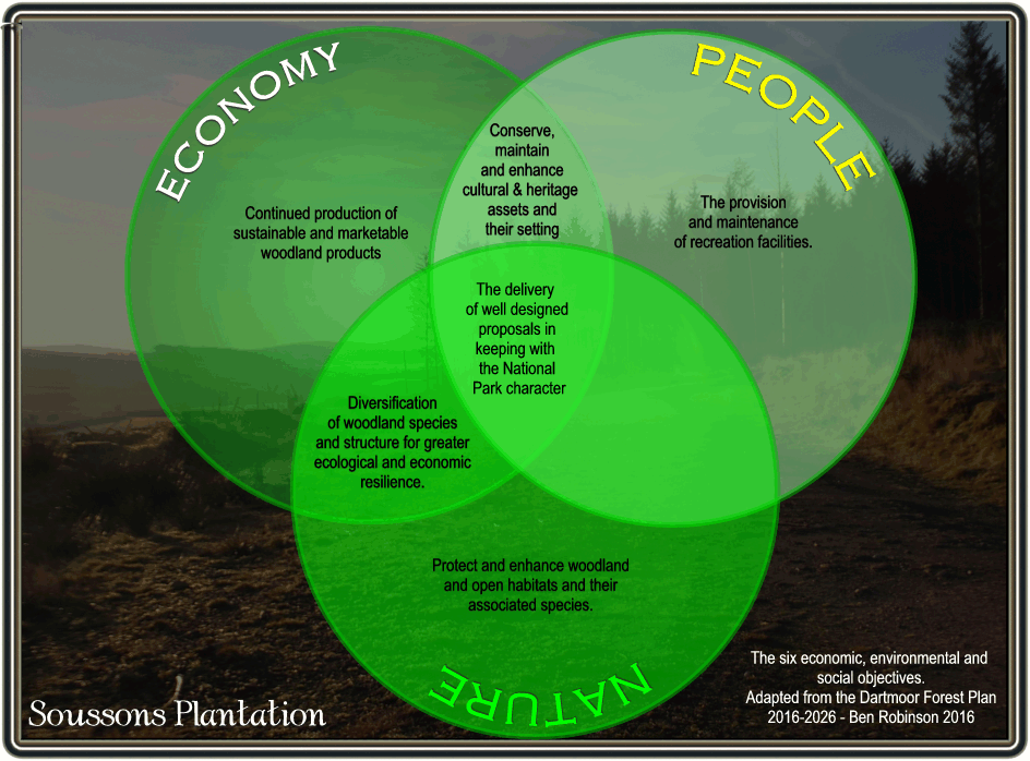
Today Soussons Plantation which is leased from the Duchy of Cornwall covers 215 hectares and was initially planted between 1947, 1949. Then in 1950, with the aid of heavier mechanical equipment for ploughing and improved planting techniques the exposed tops above 450m were planted with Sitka in 1950. As part of the ‘Moor Than Meets the Eye’ project The Dartmoor Forest Plan (DFP) was proposed which will provide sustainable management of the woodland that will be to the standards required to maintain FSC and PEFC accreditation and therefore must deliver six economic, environmental and social objectives. These are shown in the diagram above. As can be seen there are three major factors to be taken into consideration; the economy, nature, and people within which sit the six main objectives. The DFP notes that; “Soussons is a block of 215 hectares of coniferous forest leased from the Duchy of Cornwall. It is surrounded by open moorland with an elevation of between 300-400m above sea level. The soils are similar to that of Bellever and Fernworthy being deep, peaty and well drained with a tendency to form an ironpan and gley towards the north of the forest. The forest is almost entirely stocked with Sitka spruce the majority of which was planted by the Duchy in the 1940s. Much of this has now either been felled and restocked or is reaching the end of its rotation. The forest is relatively exposed and having been delayed in its first thinning the older crops do not lend themselves to CCF transformation. The forest is rich with cultural heritage which is in varying condition, this together with quality scrub and open habitat adjacent to conifer crops delivering quality habitat for a number of nationally important moorland species, creates a valuable forest in the landscape.”
Contained in the Dartmoor Forest Plan is an analysis of the plantation which identifies nine salient factors to be taken into cosideration along with the actions proposed to ensure the stability of plantation’s habitat and also to maintain its ecological and amenity value. These are:
1) Analysis: Tinworks, field systems, settlements, warren, cairns and a stone alignment at Headland Warren as well as round barrow found in northern region of the forest. Some of these are under tree cover and others on very uneven/steep ground.
Proposal: The aim is to restore and maintain these heritage assets free from tree cover to preserve and enhance their cultural value for perpetuity, as agreed with Historic England.
2) Analysis: Some small areas of crops are exposed and susceptible to wind blow.
Proposal: Assess the stability of these crops and consider felling to reduce the risk and impact of windthrow.
3) Analysis: Soussons Farm is located in close proximity to the south-east corner of the forest with the trees providing substantial shelter from the wind.
Proposal: Proposals will look to minimise the impact of felling on Farm as appropriate.
4) Analysis: Walla Brook and West Weyburn (think that should be Webburn) River flank the western and eastern edges of the forest with a number of small streams and drains flowing from within the forest into these watercourses.
Proposal: Surrounding areas will be managed sensitively as riparian zones, where soil and nutrient stability are prioritised. With the objective to reach 50% continuous cover of site associated wet woodland species where appropriate. Soussons Down to Forestry Commission which fenced, deep ploughed and planted 550 acres (223 ha) with conifers.
5) Analysis: A ring cairn (Scheduled Monument) is situated on the south edge of the forest and is in keeping with the rich cultural heritage of the region.
Proposal: This heritage asset will be maintained free from tree cover to preserve its cultural value and enhance its setting as agreed with Historic England.
6) Analysis: Significant area of spruce crops reaching economic maturity, having had first thinning delayed and then conventionally thinned.
Proposal: Manage through clearfell and restock despite some indication of natural regeneration now in evidence.
7) Analysis: Area of managed open space showing significant scrub encroachment.
Proposal: A suitable site for future compensatory planting for other, more appropriate open space creation proposals.
8) Analysis: East Dartmoor SSSI (SAC) borders the forest boundary. Many of the units in proximity to forest are in ‘unfavourable – recovering’ condition.
Proposal: Proposals will complement the SSSI where appropriate and aid its recovery to favourable’ condition.
9) Analysis: Popular tourist route, B3212, has extensive views into the woodland from a higher promontory.
Proposal: The Plan will look to create and maintain the forest as a valuable landscape feature.
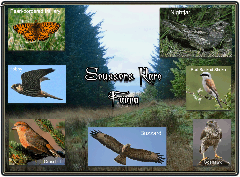
Within the plan are proposals for felling and restocking sections of Soussons Plantation between 2016 and 2026. As far as restocking goes it has been suggested that new species of evergreen, broadleaf trees are introduced to get away from the dominance of Sitka Pine. These include; Scots Pine, Pacific Silver Fir, Noble Fir, Douglas Fir, Western Hemlock, Grey Alder, Beech, Aspen, and Rowan – there are also plans to introduce more open spaces. It has been estimated that the felling work will create around 1,000 man days work each year and the management operations such a planting, weeding and fencing will provide 350 days per year. Between 2017 and 2021 the timber production at Soussons has been forecast to contribute over 7.5% of the Forestry Commission’s West of England District total volume. Soussons Plantation provides an excellent habitat for a wide range of common and rare species such as the; Goshawk, Hobby, Buzzard, Nightjar, Crossbill, Red-Backed Shrike and the pearl-bordered Fritillary. It is also home to non-native flora and fauna which can have an adverse effect on the plantation’s habitat should their population get too big, these include; wild deer, squirrels, rhododendron along with sheep and ponies which at times can encroach on the plantation. These need to be managed properly in order not to have an impact of the habitat and woodland crop. The full Master Document for Dartmoor Forest Plan 2016-2026 is available as a free pdf – HERE.
With so many reminders of the ancient past dotted around the plantation it is no wonder that the odd folklore tales have attached themselves to it. The infamous and dreaded ‘Black Dog‘ was said to roam the common in search of its victims on dark nights. Crossing suggested that whilst ghosts need no sustenance the diabolical creature may have enjoyed chasing the rabbits who inhabited Soussons Warren, 1997, p. 54. In light of the above examples of poachers who appeared in court for their crimes could it be that the tale was told in order to deter the more superstitious night prowlers from entering the warren? Finally if you would like to see our Xploration of Soussons Plantation click – HERE.

Butler, J. 1991. Dartmoor Atlas of Antiquities – Vol. 2. Exeter: Devon Books.
Butler, J. 1997. Dartmoor Atlas of Antiquities – Vol. 5. Exeter: Devon Books.
Baring Gould, S. 1903. Exploration of Red Barrows. Transactions of the Devonshire Association – XXVV. Plymouth: Brendon & Son.
Crossing, W. 1996. Crossing’s Dartmoor Worker. Newton Abbot: David & Charles.
Crossing, W. 1990. Crossing’s Guide to Dartmoor. Newton Abbot: Peninsula Press.
Crossing, W. 1997. Folklore and Legends of Dartmoor. Liverton: Forest Publishing.