 Legendary Dartmoor The many aspects past and present of Dartmoor

‘Close to Hennesbury Gate is a hut-circle known as Seven Lords’ Lands, from the fact that seven manors meet there.’, Page, p.217.
‘A gunshot or two from Hennesbury Gate, and close to the parish boundary wall, is a very perfect hut circle, or aboriginal dwelling, known from medieval times as Seven Lords’ Lands, for it is a boundary point where seven manors meet.’ Dymond, p.5.
What a very evocative name – Seven Lords’ Lands, does not that conjure up images of seven noble knights standing on a hilltop and surveying the extent of their vast estates? If this was the case then they certainly were not the first to do so because despite what both Page and the Ordnance Survey of 1889 tell us Seven Lords’ Lands is in fact a prehistoric cairn. The now vegetation covered pile of rocks dates back to the Bronze Age and today stands at about 0.6m at the centre with a 10m diameter, Butler, 1991, p.62. There is evidence that a kerb of closely spaced surrounded the cairn which displays six of the original stones still in-situ. A sickening shallow depression in the centre of the cairn suggests that at some stage the monument has suffered at the hands of either antiquarians or looters. However for once this was not so for in 1946 Hansford Worth reported that the cairn circle had been converted into a shelter trench by; “some ingenious soldier.” However, despite this intrusion the cairn remains in a fairly good state of preservation when compared to some of Dartmoor’s cairns. So much so that in Butler’s opinion there still may be an undisturbed burial underneath. If one looks at the wider landscape this cairn is by no means the only example in the area and is probably associated with the Bronze Age settlement at Foale’s Arrishes.
To find an explanation of the place-name one must move away from the prehistoric era and leap forward to the medieval period when either by design or accident the cairn supposedly became a meeting place of seven manorial bounds. This theory held good for many years and has been proffered by many Dartmoor writers, (Hemery, 1983, p.732/Crossing, 1990, p.312). In all reality the seven manorial bounds co-join within the vicinity of the cairn not exactly at the cairn, these manors are; Widecombe Town, Natsworthy, Buckland, Bagtor, Halshanger, Great Houndtor and Dunstone with Blackslade. This phenomenon is by no means exclusive to Seven Lords’ Lands as up and down the country there are numerous examples of boundaries using prehistoric landscape features as markers. This can be argued is because such monuments have always been regarded as sacred and therefore afforded the respect of later generations.
This story took an exciting turn in the 1990s when Dave Brewer stepped beyond the obvious and moved into the realms of Saxon ‘Hundreds’ and in particular the Kerswell Hundred which later became the Haytor Hundred. The Kerswell Hundred was split into two sectors, the first had its administrative centre around what is now Kingskerswell. The second sector although being called the Haytor Hundred did not encompass Haytor itself, it did however comprise of the following manors; Widecombe Town ( North Hall), Natsworthy, Spitchwick, Blackaton Pipard, Jordan, Buckland and Dunstone with Blackslade. It is known from the Cartulary of Torre Abbey that the sworn men of the Kerswell Hundred used to meet on a monthly basis at a hill then known as Kyngesdone. The purpose for these meetings was to allow the delegates to discuss and debate the various issues that had arisen within their respective hundred, Brewer, 2002, p.113 -114, 1994, pp. 30 – 31. Therefore if this was the norm for Anglo Saxon administration would it not have been logical to say that also such sworn men from the Haytor Hundred also met on a monthly basis?
In 1994 Mike Brown found a small piece of parchment lodged in the bowels of the West Devon Record Office which turned out to be a record of the beating of Buckland bounds from 1683. The description of Seven Lords’ Lands was as follows: ‘Hoartsberry where the seven Lords meete and seven stones are pitched up together to each Lord a stone, and the stone that belongs to the Lord of the Manor of Buckland is the South Stone save one‘, p.14. Clearly this entry does not give the date and origins of this custom but along with the evidence from the Cartulary of Torre Abbey would suggest a long tradition. If meetings were held at Seven Lords’ Land then this would in effect classify the place as a ‘Moot Hill’, moot stemming from the old Saxon word for a court or council – möt. Other indicators to the age of the area can be seen in nearby Harefoot Cross and Harefoot Mires, both contain the element hēre which is an Anglo Saxon word meaning ”dignity or importance, Clark Hall,p.18. Could this allude to Seven Lords’ Land as a place of importance or where dignitaries met?

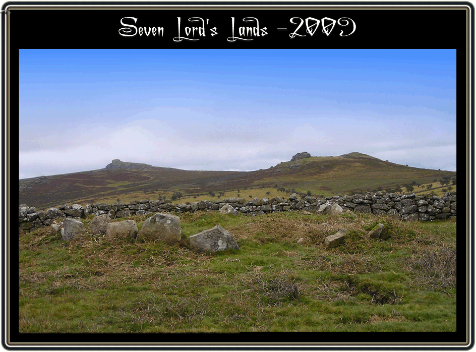
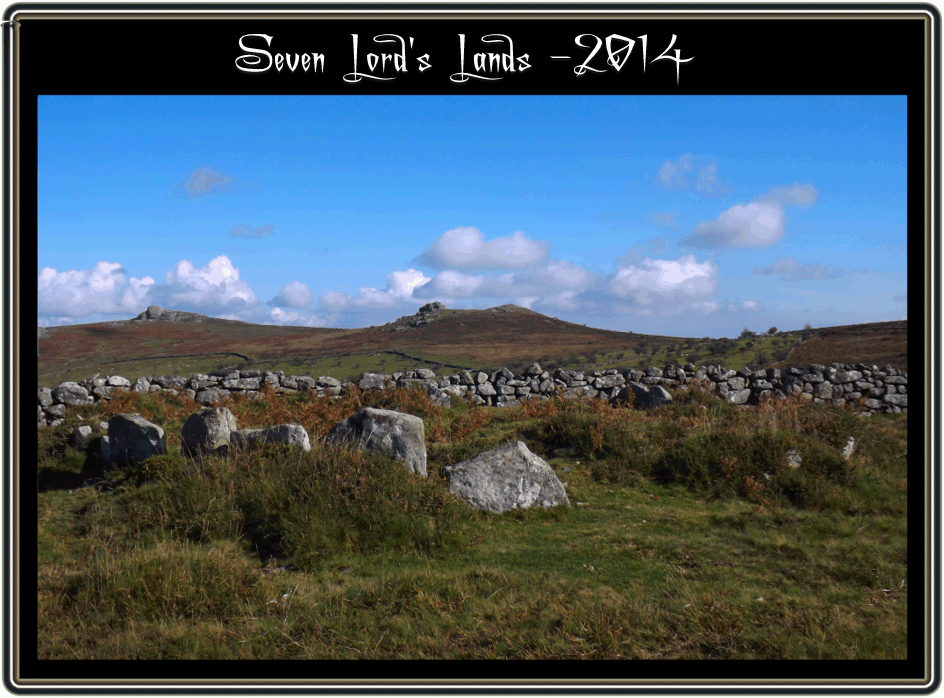
There is enough evidence to show that Seven Lords’ lands has an important place in the historical record of Dartmoor especially as it is, to the best of my knowledge, the only place of its kind on the moor. However the monument has not been without its trails and tribulations as noted above but now the monument has suffered the indignation of being covered with gorse to such an extent that it’s almost invisible. The Dartmoor Magazine reported in the spring of 2008 that the editor on four occasions has reported this deplorable state of affairs to the Dartmoor National Park Authority. The then Chief Executive responded with the normal DNPA arrogance stating that as the monument was scheduled and that the authority had no responsibility of care towards it, Stanbrook, p.4. Stanbrook also reported that a member of the public had informed her that they too had written to the DNPA complaining about the state of the cairn. That was two years ago and there has been no reply forthcoming – what a surprise. It is interesting to see that the brand spanking new information centre which has just been built two miles down the road at Haytor was in 2007 projected to cost £336,750.00p? Well, finally (September 2009) the gorse was cleared and again you can see the Seven Lord’s Lands cairn in all its glory, however the march of gorse and bracken is timeless and by 2014 it had started to regrow as can be seen from the photo above. In the summer of 2016 there was a mini digger doing some kind of work near to the cairn circle so maybe the vegetation will once gain be removed.

Brewer, D. 2002. Dartmoor Boundary Markers. Tiverton: Halsgrove Publishing.
Brewer D. 1994. Seven Lords’ Lands Cairn Circle. Dartmoor Magazine No. 37. Brixham: Quay Publications.
Brown, M. 1994. Dartmoor Field Guides – No. 42. Plymouth: Dartmoor Press.
Butler, J. 1991. Dartmoor Atlas of Antiquities – Vol. I. Exeter: Devon Books.
Clark Hall, J. R. 2004. A Concise Anglo-Saxon Dictionary. London: University of Toronto Press.
Crossing, W. 1990. Crossing’s Guide to Dartmoor. Newton Abbot: Peninsula Press.
Dymond, R. (ed.) 1876. The Parish of Widecombe-in-the-Moor and its Neighbourhood. Torquay: Torquay Directory Co.
Hemery, E. 1983. High Dartmoor. London: Hale Publishing.
Page, J. Ll. W. 1895. An Exploration of Dartmoor. London: Seeley & Co. Ltd.
Stanbrook, E. 2008. Seven Lords’ Land Cairn. Dartmoor Magazine – No. 90, Brixham: Quay Publications.