 Legendary Dartmoor The many aspects past and present of Dartmoor

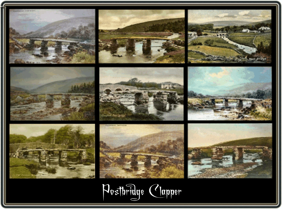
The ‘legendary’ Postbridge Clapper has got to be one of the top three ‘hotspots’ on Dartmoor. How many people that have visited the moor have not got either a photo or a postcard of the old bridge? Visit Postbridge on any summer’s day and see the buses piling into the car park. A traffic survey carried out in the Easter 1998 showed that around 800 vehicles an hour were crossing over the present road bridge. It is a shame because although it is one of the largest of the Dartmoor Clapper bridges, there are other far more picturesque. Luckily the others don’t have a convenient car park and merely involve a walk of over 500 yards to reach them. Never the less the bridge has a long and at times literally turbulent history.
At one time grandly known by some as the ‘cyclopean bridge’, Postbridge Clapper in one form or another has stood here for centuries. The term ‘clapper bridge’ is a term used on Dartmoor for a bridge which has one or more flat slabs of stones which rest on stone piers and thus spans a river or stream. The Dartmoor term for the slabs are in local parlance – pawsts or ‘posts’ which is how Postbridge acquired its name. However, there is another fanciful suggestion as to the name’s origin and that was the ‘Post’ element derived from the fact that the road over the bridge was the old post road which carried the mail and passengers from Extender to Plymouth? It is possible that the bridge dates back as early as the 1300’s as by this time many of the nearby moorland farms had been established. The earliest documented record of the bridge is from a newtake lease of 1655 where it states: “scituate lyinge and beinge between postbridge and a nutake of on Richard Leeres…” The bridge then appears on John Ogilby’s Exeter to Truro road map of 1675 where it is marked as “a Stone bridge, 3 Arches Called Post bridge.”
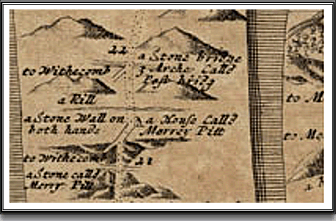
Ogilby’s Map of 1675 – Itinerarium Angliae
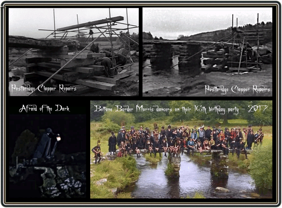
In 1795 the Rev. John Swete in his Illustrated Journals of Georgian Travels in Devon gave the first description of the bridge, “tis impossible to form an impression of a Structure, more simple than this, or better adapted to the situation…” The actual bridge consists two central posts (piers) upon which is laid a single slab of granite from each bank and two smaller slabs in the middle. The four slabs of granite span a length of 42ft 6″ (12.95m) and at the widest point measure 9ft (2.7m) It has been estimated that the two side slabs weigh anything between 6.5 and 8 tons each with the two central sections coming in at around 2 tons apiece. There have been two suggestions as to where the granite slabs came from; Robert Burnard considered that they were taken from Bellever tor which is about a mile and a half away. However, Jack Warne, a one-time moorman suggests Lower White Tor as the source, this is around two miles away. The actual geological make-up of the slabs are different as the feldspar content of the two central slabs differ from that of the side ones, possibly suggesting two separate sources. Either way it was no mean feat to transport such heavy slabs of granite from whatever distance and would have certainly involved the use of sleds and ponies. The main supporting piers are built from large stone blocks and consist of 5 – 6 courses. The eastern pier is the one that experiences the largest force of the flowing river and so has a pointed ‘cutwater’ to help deflect the water. Sometime in the 1800’s large wooden beams were suspended by chains from downstream side of the bridge to act as cattle barriers, Greeves & Stanbrook, 2004. Sometime between 1825 and 1830, William Crossing describes how a local farmer came up with the notion of trying to tip the bridge slabs into the river, these would fall on their edges thus forming a dam which in turn would form a pond for his ducks. The slabs would allow the water to flow under but also act as a barrier to retain his ducks. The first slab to get dumped in the river was the upstream or northerly of the two centrals, this however decided to land face-down on the riverbed thus thwarting the farmers plans. p.64, Greeves & Stanbrook describe how in the October 1879 major restoration work was carried out on the bridge. The fallen slab was recovered from the river bed and placed back in-situ and the total cost of the operation came to £4. 8s. Further repairs were carried out in 1970 when it was noticed that one of the central piers was leaning thus leaving a slab precariously resting on just 1.5″ (38mm) of post. The operation entailed jacking up all the slabs and then rebuilding both piers with the stones being fixed with epoxy resin cement, having done so the slabs were lowered back into position and also secured with epoxy resin cement. Finally in 1979 repair works to the river banks was carried out by the Dartmoor National Park Authority, it was during this operation that the steps leading up to the bridge were built.
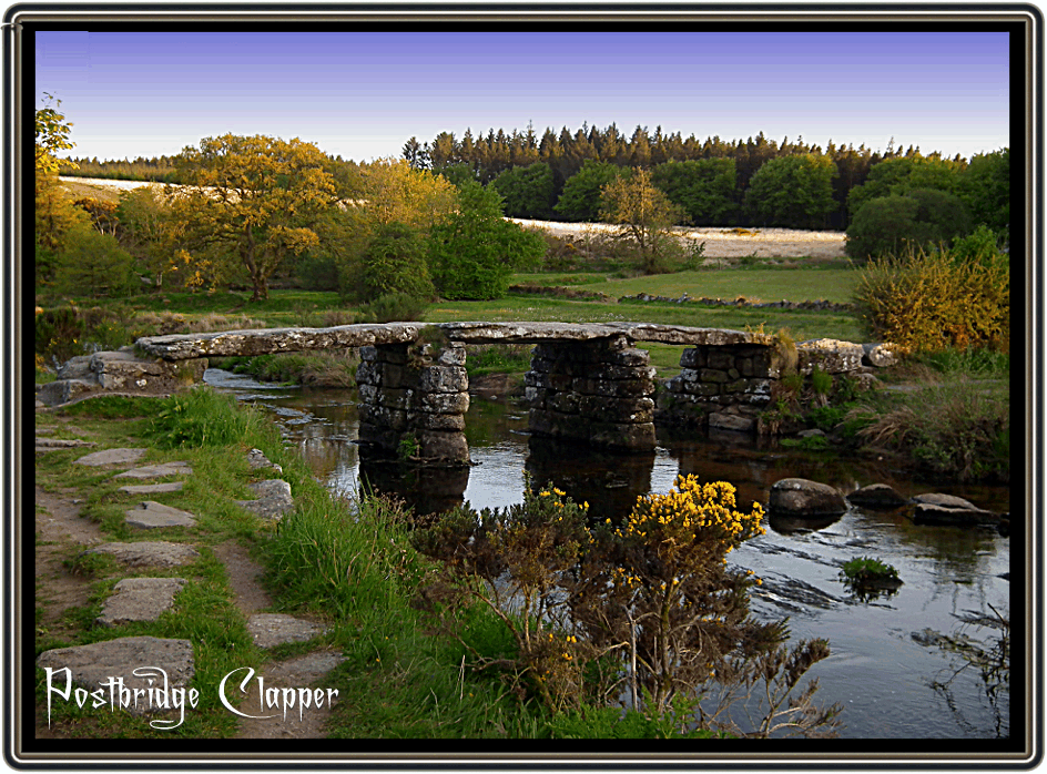
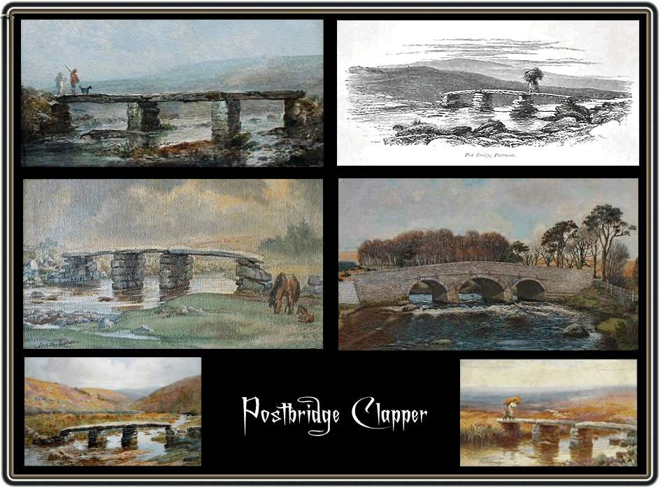
Bellamy tells us that the present road bridge was built around 1792 when the Tavistock to Moretonhampstead turnpike road was constructed. p.12. It is possible that the site of the present bridge was where the old ford was. There are two ‘C’ (County) stones each side of the bridge which marks the stretch of road which originally the Devon County Council were responsible for. If you look at the photograph above you see a gently flowing East Dart River but on at least three occasions flood waters have either reached or flooded over the bridge spans, this was in 1890, 1938, and 1992. It is worth noting that the depth under the bridge is 6ft 7″ (2m). On every occasion the bridge stood up to the deluge which surely is testament to its design.
Probably my weirdest memory of the clapper was a few years back when I was taking part in the making of a History Channel’s documentary called ‘Afraid of the Dark’. They wanted some footage of a person dressed in a monk’s cowl crossing the bridge in the dark (see photo above). The idea was to portray the ‘perils’ of travelling across Dartmoor in days of old. Previous to the filming a storm had passed through Postbridge and it being pitch black and the old clapper dangerously slippy nobody volunteered for the role. So being the only local person it was suggested that I would have enough intimate knowledge to make the perilous crossing. Having donned the cowl and with walking staff and lantern in hand I carefully crossed the bridge, but the cameraman was not happy with my first crossing and I had to make it again. Once more I mounted the bridge and steadily made my way across only to hear that once again their was a problem. This time the cameraman noticed that the cowl ended a few inches above my ankles and my sturdy walking boots were plainly visible. Seemingly the fact that a medieval traveller would not be wearing modern-day walking boots was not authentic enough so I was cast out of the role.
On the occasion of the Beltane Border Morris’ 16th birthday they hired a vintage bus and took a tour around Dartmoor which included a stop at the old clapper bridge in Postbridge. If there was such a thing this would surely going into the ‘Dartmoor Book of Records’ for the most number of people on the clapper at one time – see photo above.

Bellamy, R. 1998 Postbridge – Heart of the Moor, Halsgrove Pub., Tiverton.
Crossing, W. 1974 Amid Devonians Alps, David & Charles, Newton Abbot.
Greeves, T. & Stanbrook, E. 2004 The Clapper Bridge – Postbridge, Quay Pub., Brixham
One comment
Pingback: Clapper Bridges - Twelve Mile Circle