 Legendary Dartmoor The many aspects past and present of Dartmoor

Buttern Hill, probably one of the lesser Dartmoor locations to get onto anyones ‘bucket list’ but nevertheless there are plenty of landscape features to behold along with some wide ranging views from its summit. The actual origin of the place-name may well give a clue to some of those landscape features both prehistoric and historic. Harold Fox considered that the first element of the place-name has derived from the Anglo Saxon word butere which means ‘butter’. Which when it’s followed by the topographical word – hill – basically gives us ‘Butter Hill’ or ‘Hill of Butter’. I recall that back in the 1970s/80s the European Union had a ‘Butter Mountain’ which was literally stores of surplus butter, however in the case of Buttern Hill this was not and is not a huge stack of butter although the name does allude to butter. In Dartmoor terms (and indeed nationally) the place-name suggests rich pasture which when grazed by dairy cows produces good butter. There is another version which argues that such a name refers to a place where butter was made but it is highly unlikely that butter was ever made in the open air of a hillside, especially when several farms lie nearby to the east of the hill. p.151. Or you could settle for another idea, that being as Grumley-Grennan and Hardy suggested when talking about Buttern farm: “The name ‘Buttern’ derives from ‘outer’ and an acceptable nomenclature would be Outer Farm on Outer Hill, ” p.134. – don’t think so somehow.
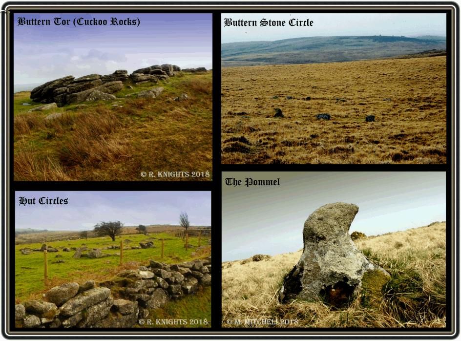
The highest point of Buttern Hill stands at 413 metres and is crowned by a cluster of rocks which Crossing refers to as ‘Buttern Tor’, p.65., additionally he also mentions the fact that; “to which the name of ‘The Cuckoo Stone’ has been given, p.236. On the these summit rocks the partly finished work of a stone cutter can be seen in the form of a forlorn and abandoned millstone. Why it was never completed will remain a mystery throughout time immemorial. There is also the rusted remains of a tethering ring (see HERE), where as Hemery informs us that it was a moorman from Buttern Farm used to tie up his pony/horse whilst he ventured further into the moor on foot. On the western ridge top of the summit is a 3.5 metre tapering standing stone with no apparent explanation. The English Heritage Pastscape Record for the stone suggests this is a post-medieval boundary marker of some kind. Another feature of the hill was once the presence of a trig point which now only exists as a mark on the old OS maps as can be seen on the map below marking the height of 1,375 ft.
As with much of Dartmoor’s remoter locations it is sometimes easy to imagine that you are the first person to set upon their soils but don’t be fooled the chances are that someone has been there way, way before you. Buttern Hill is such a place and the field evidence suggests that someone was treading on what was then hallowed ground some 5,000 years ago. Just to the east of the Square Pound the OS maps ( SX6567 8855) show that there are the remnants of a chambered cairn. This ritual burial feature has been dated to the Neolithic period and basically consisted of a stone built chamber of stones within a mound of stones (cairn). Today was the cairn stands to just over half a metre tall and the actual chamber itself is now represented by five orthostats and at the entrance by a further two (see HERE). The evidence of a leat may well suggest that some damage had been caused to the feature by its construction in more recent years. Some 450 metres NNE of this chambered cairn is a second one located at OS grid reference SX 6586 8895. In this instance “The cairn mound measures 26 metres long and 9 metres wide and stands up to 1 metre high. Several set stones at the western end of the mound represent the remains of a passage leading towards a chamber.” Butler, p. 157.
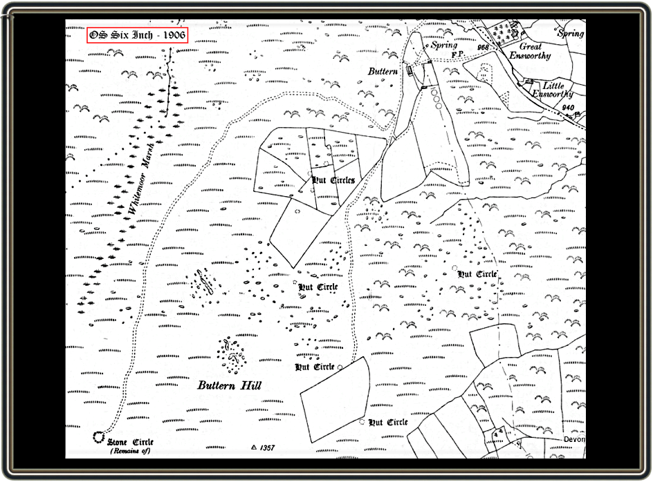
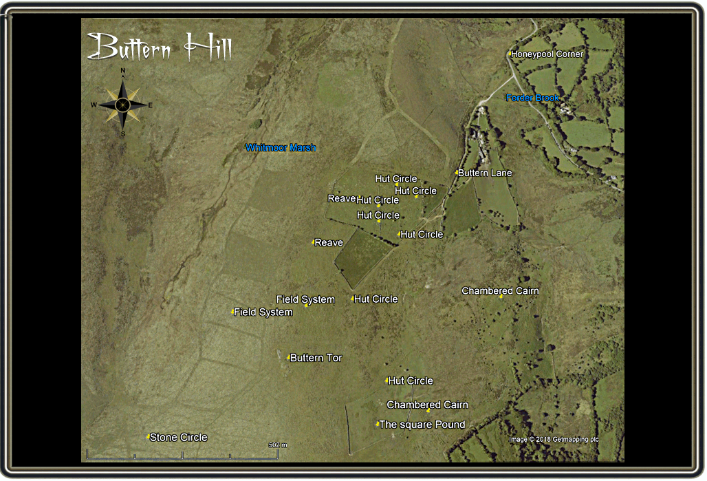
Look on any OS map and you will see a number of hut circles dotted around the lower eastern and northerly slopes along with their associated field systems and reaves. These would have been the settlements of Bronze Age people who had decided that this location was ‘prime real estate’. The largest nucleated settlement being that in the farm enclosures centred at OS grid reference SX655 891. There is certainly a convenient nearby water supply in the form of the Forder Brook and if the above theory is correct then there was quality pasturage for grazing their livestock.
As with most prehistoric settlements there will be associated ritual monuments and Buttern Hill proves to be true to form. Probably one of the more notable is the stone circle located at OS grid reference SX 6494 8847. Today when compared with some of Dartmoor’s other stone circles it proves to be disappointing but originally it would have come halfway up the size table. Writing back in 1894 Mr. R. N. Worth wrote: “Though one of the finest, this is certainly the least known of the larger circles on Dartmoor. It is remarkable for occupying a position on low ground, all but at the bottom of a shallow valley westward of Buttern Hill – a circumstance which militates heavily against the ‘sacred’ ides. Most of the stones are fallen – indeed only half-a-dozen are still earthfast; but nearly all the stones are present – if not quite all, and I have counted 36 more or less in place. Some are of considerable size, the longest 6 ft. 9 in., another 5 ft. 8 in. , others between four and five feet. One of the standing stones has a curious top, much resembling the rudely formed head and beak of a bird, but this is evidently natural. The diameter of the circle cannot be taken exactly, as so many of the stones are down – but it was between 80 and 90 feet. There is no trace of a row or associated menhir, but there is a very significant sepulchral fact, in the presence of the remains of a small cairn between five and six yards in from the southern edge.
Throwleigh circle is also noteworthy for having a companion, a short distance on the slope to the westward. The existence of this circle has not been put on record until now, and indeed it might well escape observation, seeing that there are only four certain stones still standing, with possibly a fifth, and that the remainder have disappeared. This circle was clearly not less than 60 feet in diameter. There is a very large block of irregular outline within its limits, which at one time may have stood fully six feet high.” – pp. 303 – 304. As he commented, in 1894 there were six stones still standing with 36 visible. If you visit the monument now there are only 17 stones which are easily detectable of which only 5 stones remain standing at a very diminutive height of o.76 metres within a radius of 24.8 metres. As can be seen from the photograph above one of the standing stones is a very odd shape to say the least – taking on the form of a western saddle’s pommel. With the amount of stone that would have been available in the nearby locality is does seem plausible that this one was especially selected for it appearance – what that might have been is anyones guess? Also noticeable in its absence is the cairn which Worth also mentions along with the second stone circle which was supposedly nearby. The modern day thinking is that; “A number of stones on the hillside do show above the turf but none appear to be artificially arranged.” Butler, p.194.
One slight mystery stems from the words of J. Ll. W. Page who in his book of 1894 wrote: “But it is on the down to the south, known as Endsworthy or Buttern Hill, that buildings of a more common interest will be found. Here is a hut circle having a partition facing the entrance, and traces of what Mr. Ormerod thinks is a chimney. Close at hand is an oblong structure nineteen feet wide divided into three chambers, the centre one having a length of twenty-five feet, flanked by smaller compartments, eleven and seventeen feet long respectively. The writer, whose paper on these remains is illustrated by a ground plan, suggests that the circular dwelling may have been a smelting-house and the rectangular edifice a store for the metal.” pp. 92 -93. It does seem highly unlikely that such a building associated with mining would be located in any of the Ensworthy enclosures? I just wonder whether he had confused Ensworthy with Emsworthy which is located near one-time mining or nearby quarrying activities? But just to confuse matters there is an old photograph on the Dartmoor Archives website which does show an odd looking building supposedly in an Ensworthy enclosure dated 1895 – see HERE. Unfortunately the photograph does not say in which particular enclosure it was taken and the OS grid reference the web page gives is a complete mystery. Certainly there is no evidence of it today and I can find no mention of this building in any of the normal Dartmoor tomes.
If we the jump into our time machine and travel forward to historic times one will see that livestock grazing in this area had continued. Evidence for this can be seen in the form of the ‘Square Pound’. Hemery talks about this saying; “Square Pound, inside which is another ruined hut-circle, was used by the Buttern moormen until recent times for herding sheep and cattle collected from the in-country for depasturage on the Moor; in it, they rested overnight at the end of their long trek and were driven out to the moor the next morning.” p.802. In all likelihood the walls of this pound were constructed from stones robbed from the nearby hut circles hence their ruined condition. Many of the old tracks leading to the ‘Square Pound’ and onto Creaber Pound about half a kilometre distant can be clearly seen on Google earth today.
To end on a ‘sweet note’, you can see at the top of the aerial map there is an enclosure belonging to Great Ensworthy Farm called – ‘Honeypool Corner’. On the 1843 Gidleigh tithe map the enclosure which covered just over an acre was an arable plot called ‘Honeypool’. Just to the west of this enclosure is Honeypool Mire through which the Forder Brook flows and over this spans the Honeypool Bridge. I would suggest that both enclosure and bridge take their names from the mire, so why should it be called so? There are two explanation; firstly that the water flowing from the mire was considered to be ‘sweet’ (as honey) and therefore pleasant to drink or secondly it was once a place where bee hives were once kept and which produced excellent honey. Is it coincidental that you have a ‘sweet’ water source along with rich pasture that will produce lush grazing which eventually provided excellent butter?

Butler, J. 1991. Dartmoor Atlas of Antiquities – Vol. 2. Exeter: Devon Books.
Crossing, W. 1990. Crossing’s Guide to Dartmoor. Newton Abbot: Peninsula Press.
Fox, H. 19902012. Dartmoor’s Alluring Uplands. Exeter: Exeter University Press.
Grumley-Grennan, T & Hardy M. 2000. Gidleigh – A Dartmoor Village. Gidleigh: Glebe Publishing.
Hemery, E. 1983. High Dartmoor. London: Robert Hale.
Page, J. Ll. W. 1895. An Exploration of Dartmoor. London: Seeley & Co.
Worth, R. N. 1894. The Stone Rows of Dartmoor. Transactions of the Devonshire Association, Vol. XXV1. Plymouth: William Brendon & Son.